Oak Grove, Minnesota

Last updated

Oak Grove
Anoka Cnty Minnesota Incorporated and Unincorporated areas OakGrove Highlighted.png
Location of the city of Oak Grove
within Anoka County, Minnesota
Coordinates: 45°20′27″N93°20′0″W / 45.34083°N 93.33333°W / 45.34083; -93.33333
CountryUnited States
State Minnesota
County Anoka
Settled1855
Organized1857
Incorporated 1993
Government
   Mayor Weston Rolf
Area
[1]
  Total35.20 sq mi (91.18 km2)
  Land33.91 sq mi (87.82 km2)
  Water1.30 sq mi (3.36 km2)
Elevation
[2]
896 ft (273 m)
Population
 (2020) [3]
  Total8,929
  Estimate 
(2022) [4]
9,130
  Density263.33/sq mi (101.67/km2)
Time zone UTC–6 (Central (CST))
  Summer (DST) UTC–5 (CDT)
ZIP Codes
55005, 55011, 55303
Area code 763
FIPS code 27-47690
GNIS feature ID2395282 [2]
Sales tax 8.525% [5]
Website ci.oak-grove.mn.us

Oak Grove is a city in Anoka County, Minnesota, United States. It is north of Minneapolis. The population was 8,929 at the 2020 census. [3]

Contents

Geography

According to the United States Census Bureau, the city has a total area of 35.16 square miles (91.06 km2), of which 33.85 square miles (87.67 km2) is land and 1.31 square miles (3.39 km2) is water. [6] County Roads 7, 9, 13, 22, and 78 are the main routes in the community. State Highway 47 (MN 47) passes briefly through the northwest corner of Oak Grove.

Lake George is located within the city of Oak Grove.

Adjacent cities

History

Oak Grove first became an organized township in 1857, and was so named because of the large groves of oak trees in the area. The village of Oak Grove was founded in 1854, and a post office operated from 1857 to 1901. The township incorporated as the city of Oak Grove in 1993. [7] [8]

Demographics

Historical population
CensusPop.Note
1860 231
1870 198−14.3%
1880 30554.0%
1890 293−3.9%
1900 49468.6%
1910 60722.9%
1920 6151.3%
1930 453−26.3%
1940 55723.0%
1950 62412.0%
1960 82632.4%
1970 1,674102.7%
1980 3,926134.5%
1990 5,44138.6%
2000 6,90326.9%
2010 8,03116.3%
2020 8,92911.2%
2022 (est.)9,130 [4] 2.3%
U.S. Decennial Census [9]
2020 Census [3]

2010 census

As of the census of 2010, there were 8,031 people, 2,744 households, and 2,237 families residing in the city. The population density was 237.3 inhabitants per square mile (91.6/km2). There were 2,882 housing units at an average density of 85.1 per square mile (32.9/km2). The racial makeup of the city was 95.8% White, 0.5% African American, 0.3% Native American, 1.9% Asian, 0.3% from other races, and 1.3% from two or more races. Hispanic or Latino of any race were 1.2% of the population.

There were 2,744 households, of which 39.8% had children under the age of 18 living with them, 72.6% were married couples living together, 4.7% had a female householder with no husband present, 4.3% had a male householder with no wife present, and 18.5% were non-families. 13.1% of all households were made up of individuals, and 3.6% had someone living alone who was 65 years of age or older. The average household size was 2.92 and the average family size was 3.21.

The median age in the city was 40 years. 26.5% of residents were under the age of 18; 7.5% were between the ages of 18 and 24; 24.6% were from 25 to 44; 33.3% were from 45 to 64; and 8.2% were 65 years of age or older. The gender makeup of the city was 52.3% male and 47.7% female.

2000 census

As of the census of 2000, there were 6,903 people, 2,200 households, and 1,883 families residing in the city. The population density was 204.9 inhabitants per square mile (79.1/km2). There were 2,232 housing units at an average density of 66.2 per square mile (25.6/km2). The racial makeup of the city was 97.20% White, 0.51% African American, 0.68% Native American, 0.48% Asian, 0.22% from other races, and 0.91% from two or more races. Hispanic or Latino of any race were 0.59% of the population.

There were 2,200 households, out of which 45.6% had children under the age of 18 living with them, 76.3% were married couples living together, 5.0% had a female householder with no husband present, and 14.4% were non-families. 10.6% of all households were made up of individuals, and 1.6% had someone living alone who was 65 years of age or older. The average household size was 3.11 and the average family size was 3.33.

In the city, the population was spread out, with 32.0% under the age of 18, 6.8% from 18 to 24, 33.8% from 25 to 44, 23.9% from 45 to 64, and 3.5% who were 65 years of age or older. The median age was 34 years. For every 100 females, there were 114.4 males. For every 100 females age 18 and over, there were 112.8 males.

The median income for a household in the city was $70,169, and the median income for a family was $73,728. Males had a median income of $44,855 versus $29,009 for females. The per capita income for the city was $23,693. About 1.0% of families and 1.5% of the population were below the poverty line, including 0.9% of those under age 18 and 3.6% of those age 65 or over.

Notable person

Related Research Articles

<span class="mw-page-title-main">East Bethel, Minnesota</span> City in Minnesota, United States

East Bethel is a city in Anoka County, Minnesota, United States. The population was 11,786 at the 2020 census.

<span class="mw-page-title-main">Ham Lake, Minnesota</span> City in Minnesota, United States

Ham Lake is a city in Anoka County, Minnesota, United States. It is a suburb in the Minneapolis–Saint Paul metropolitan area. The population was 15,296 at the 2010 census. It is in the Anoka-Hennepin School District, one of Minnesota's largest school districts.

<span class="mw-page-title-main">Ramsey, Minnesota</span> City in Minnesota, United States

Ramsey is a suburban city 22 miles (35 km) north-northwest of downtown Minneapolis in Anoka County, Minnesota, United States. The population was 27,646 at the 2020 census. It is a northwest suburb of the Twin Cities.

Oak Lawn Township is a township in Crow Wing County, Minnesota, United States. The population was 1,793 at the 2000 census.

<span class="mw-page-title-main">Clarks Grove, Minnesota</span> City in Minnesota, United States

Clarks Grove is a city in Freeborn County, Minnesota, United States. The population was 706 at the 2010 census.

<span class="mw-page-title-main">Spring Grove, Minnesota</span> City in Minnesota, United States

Spring Grove is a city in Houston County, Minnesota, United States. The population was 1,330 at the 2010 census. It is part of the La Crosse-Onalaska, WI-MN Metropolitan Statistical Area.

<span class="mw-page-title-main">Lake Bronson, Minnesota</span> City in Minnesota, United States

Lake Bronson is a city in Kittson County, Minnesota, United States. The population was 178 at the 2020 census. Lake Bronson State Park is nearby.

Oak Park Township is a township in Marshall County, Minnesota, United States. The population was 165 as of the 2000 census.

<span class="mw-page-title-main">Grove City, Minnesota</span> City in Minnesota, United States

Grove City is a city in Meeker County, Minnesota, United States. The population was 624 at the 2020 census.

<span class="mw-page-title-main">Maplewood, Minnesota</span> City in Minnesota, United States

Maplewood is a city in Ramsey County, Minnesota, United States. The population was 42,088 at the 2020 census. Maplewood is ten minutes' drive from downtown Saint Paul. It stretches along the northern and eastern borders of Saint Paul.

<span class="mw-page-title-main">Roseau, Minnesota</span> City in Minnesota, United States

Roseau is a city in, and the county seat of, Roseau County, Minnesota. Its population was 2,744 at the time of the 2020 census.

Grove Township is a township in Stearns County, Minnesota, United States. The population was 493 at the 2010 census. The township includes the southern one-third of the City of Melrose and the City of Greenwald.

Oak Township is a township in Stearns County, Minnesota, United States. The population was 595 at the 2010 census. The township includes the cities of Freeport and New Munich.

<span class="mw-page-title-main">Cottage Grove, Minnesota</span> City in Minnesota, United States

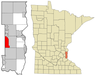
Cottage Grove is a city 10 miles (16 km) south of Saint Paul in Washington County in the State of Minnesota. It lies on the north bank of the Mississippi River, north of the confluence with the St. Croix River. Cottage Grove and nearby suburbs form the southeast portion of Minneapolis-Saint Paul, the 16th-largest metropolitan area in the United States, with about 3.69 million residents. Its population was 38,839 at the 2020 census.

<span class="mw-page-title-main">Oak Park Heights, Minnesota</span> City in Minnesota, United States

Oak Park Heights is a city in Washington County, Minnesota, United States. The population was 4,849 at the 2020 census.

<span class="mw-page-title-main">Oakdale, Minnesota</span> City in Minnesota, United States

Oakdale is a city in Washington County, Minnesota, United States. It is a suburb of Saint Paul and is on the eastern side of the Twin Cities Metropolitan area. The population was 28,303 at the 2020 census. Oakdale is the 36th largest city in Minnesota by population.

<span class="mw-page-title-main">Meire Grove, Minnesota</span> City in Minnesota, United States

Meire Grove is a city in Stearns County, Minnesota, United States. The population was 179 at the 2010 census. It is part of the St. Cloud Metropolitan Statistical Area.

<span class="mw-page-title-main">Oak Grove, Pawnee County, Oklahoma</span> Town in Oklahoma, United States

Oak Grove is a town in Pawnee County, Oklahoma, United States. The population was 22 as of the 2020 Census, up just slightly from the figure of 18 reported in both the 2000 census and the 2010 census.

<span class="mw-page-title-main">Oak Grove, Dodge County, Wisconsin</span> Town in Wisconsin, United States

Oak Grove is a town in Dodge County, Wisconsin, United States. The population was 1,126 at the 2000 census. The unincorporated community of Minnesota Junction is located in the town. The unincorporated community of Rolling Prairie is also located partially in the town.

<span class="mw-page-title-main">Oak Grove, Jackson County, Missouri</span> City in Missouri, United States

Oak Grove is a city in Jackson and Lafayette counties in the U.S. state of Missouri. The population was 8,157 at the 2020 census. It is part of the Kansas City metropolitan area.

References

  1. "2020 U.S. Gazetteer Files". United States Census Bureau. Retrieved July 24, 2022.
  2. 1 2 U.S. Geological Survey Geographic Names Information System: Oak Grove, Minnesota
  3. 1 2 3 "Explore Census Data". United States Census Bureau . Retrieved January 21, 2024.
  4. 1 2 "City and Town Population Totals: 2020-2022". United States Census Bureau. January 21, 2024. Retrieved January 21, 2024.
  5. "Oak Grove (MN) sales tax rate" . Retrieved January 21, 2024.
  6. "US Gazetteer files 2010". United States Census Bureau. Archived from the original on January 12, 2012. Retrieved November 13, 2012.
  7. Upham, Warren (2001). Minnesota Place Names (3rd ed.). Saint Paul, Minnesota: Minnesota Historical Society Press. ISBN   0-87351-396-7. Archived from the original on September 27, 2011. Retrieved July 1, 2010.
  8. "Geographic Change Notes: Minnesota". 1990s boundary changes. United States Census Bureau . Retrieved July 6, 2009.
  9. United States Census Bureau. "Census of Population and Housing" . Retrieved June 4, 2015.
  10. "Golan the Insatiable: A Darker Calvin and Hobbes", IGN, January 11, 2014.