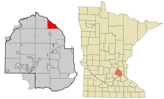
Anoka County is the fourth-most populous county in the U.S. state of Minnesota. As of the 2020 census, its population was 363,887. The county seat and namesake of the county is the city of Anoka, which is derived from the Dakota word anoka meaning "on both sides", referring to its location on both banks of the Rum River. The largest city in the county is Blaine, the tenth-largest city in Minnesota and the sixth-largest Twin Cities suburb.

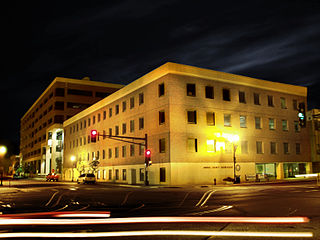
Anoka is a city in and the county seat of Anoka County, Minnesota, United States. Its population was 17,142 at the 2010 census. Anoka is the "Halloween Capital of the World" because it hosted one of the first Halloween parades in 1920. It continues to celebrate the holiday each year with several parades. Anoka is a northern suburb of the Twin Cities. U.S. Highways 10 / 169 and State Highway 47 are three of Anoka's main routes, and it has a station on the Northstar Commuter Rail line to Minneapolis.
Champlin is a city in Hennepin County, Minnesota, United States. The population was 23,919 at the 2020 census. Champlin is a northern suburb of Minneapolis.

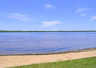
Blaine is a suburban city in Anoka and Ramsey counties in Minnesota, United States. Once a rural town, Blaine's population has increased significantly in the last 60 years. For several years, Blaine led the Twin Cities metro region in new home construction. The population was 70,222 at the 2020 census. The city is mainly in Anoka County, and is part of the Minneapolis–Saint Paul metropolitan area.
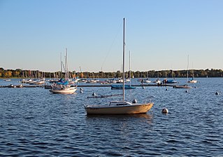
Bde Maka Ska is the largest lake in Minneapolis, Minnesota, United States, and part of the city's Chain of Lakes. Surrounded by city park land and circled by bike and walking trails, it is popular for many outdoor activities. The lake has an area of 401 acres (1.62 km2) and a maximum depth of 87 feet (27 m).
Okamanpeedan Lake, partially located in Martin County, Minnesota, and Emmet County, Iowa, is also known as Tuttle Lake. Okamanpeedan Lake is a roughly 2,300-acre (9.3 km2) riverine lake located on the East Fork of the Des Moines River. It has an average depth of about four to six feet. The lake has a contributing watershed of approximately 120,056 acres (486 km2) and watershed:lake ratio on the order of about 50:1. The lake is situated in a glacial till plain and is generally in an area dominated by loamy, poorly drained soils. The area is primarily level but does have some rolling hills.
Green Lake — also known as Big Green Lake — is a lake in Green Lake County, Wisconsin, United States. Green Lake has a maximum depth of 237 ft (72 m), making it the deepest natural inland lake in Wisconsin and the second largest by volume. The lake covers 29.72 km2 and has an average depth of 30.48 m (100.0 ft). Green Lake has 43.94 km (27.30 mi) of diverse shoreline, ranging from sandstone bluffs to marshes.

Palisade Head is a headland on the North Shore of Lake Superior in the U.S. state of Minnesota. It is part of Tettegouche State Park but not contiguous with the rest of that park. Palisade Head is located at milepost 57 on scenic Minnesota State Highway 61 in Lake County, approximately 54 miles (87 km) northeast of Duluth and 3 miles (4.8 km) northeast of Silver Bay.
Lake Noquebay is a large freshwater lake in northeastern Wisconsin. It is the largest lake in Marinette County. It is located north of Green Bay, Wisconsin, approximately 4 miles (6.4 km) northeast of Crivitz, Wisconsin.

Spring Lake State Fish and Wildlife Area is an Illinois state park on 2,032 acres (822 ha) in Tazewell County, Illinois, United States.
Crystal Lake is a lake in Burnsville, Dakota County, Minnesota. The lake is a primary source of recreation for the city of Burnsville and the surrounding area. Crystal Beach Park , Crystal Lake West Park and Tyacke Park all have coastline along the lake and offer amenities such as boat landings, picnic areas, hard surfaced courts, playground equipment, walking trails, and others. Nearby Lac Lavon Lake Park has a softball complex, tennis courts, and horseshoe courts. The Lake also contains two islands, Picnic Island and Maple Island. The most southerly parts of the lake extend into the city of Lakeville.
Lake Cadillac is a lake located within the city of Cadillac, Michigan. It is part of the Muskegon River watershed.

Castle Rock Lake is an artificial lake on the Wisconsin River. It is located in central Wisconsin in Adams County and Juneau County. The lake has an inflow from Petenwell Lake, Yellow River, Big Roche a Cri., and Klien Creek. It has a surface area of 16,640 acres (67.3 km2) and its depth varies from 8–20 ft (2.4–6.1 m) in most places, with area in the old river beds reaching as deep as 35 ft (11 m).

Curlew Lake is a 921-acre (3.73 km2) lake located in the glacier-carved Curlew Valley northeast of Republic, Washington. The spring- and stream-fed lake is named for the long-billed curlew, Numenius americanus, that once frequented the area. The 7-mile-long (11 km) lake reaches a maximum of 1⁄3 miles wide and includes four small islands.

Lake Rescue is located in Windsor County of south central Vermont, in the northeastern United States. Occupying 180 acres (73 ha) and reaching depths of 95 feet (29 m), it is the tenth-deepest and 23rd-largest lake in the state. Lake Rescue is located along VT Route 100 about three miles north of Ludlow and Okemo Mountain, and it is surrounded by the town of Ludlow. The lake is fed by the Black River and is the third of four lakes extending from Plymouth, Vermont through Ludlow, with Lake Amherst and Echo Lake to the north and Lake Pauline to the south. The northern section of the lake, connected to the main body via a shallow channel, is referred to as Round Pond.

Greenleaf Lake State Recreation Area is a state park unit of Minnesota, USA, currently in development. It includes undeveloped shoreline on both Greenleaf and Sioux Lakes, halfway between the cities of Hutchinson and Litchfield in Meeker County. Portions of the state recreation area (SRA) are open to the public for day-use recreation, but there are no facilities yet on site. The park boundaries were set by the Minnesota Legislature and the state is still acquiring land from willing sellers; two-thirds of the property remain privately owned.
Fox Lake is a 2,713 acre lake in Dodge County, Wisconsin. The City of Fox Lake, and the communities of Lyndon Dale and Delbern Acres are found along the shoreline. There are two boat landings that are open to the public, found in parks on the northwest and southeast sides of the lake. Fish present in the lake are Panfish, Muskellunge, Largemouth Bass, Northern Pike, and Walleye. Fox Lake is split by the peninsula, that the community of Lyndon Dale is located on, in the south end of the lake. This forms a bay known as The Jug, near the City of Fox Lake. According to the DNR, the bottom of the lake is 1% sand, 30% gravel, and 69% muck. The lake goes through the Fox Lake Dam, into Mill Creek, then flows to Beaver Dam Lake. The Fox Lake Correctional Institution is less than a mile from the north shore of the lake.

Medicine Lake is an inland lake located approximately 8 miles northwest of downtown Minneapolis, Minnesota. The lake lies within Hennepin County and is surrounded by two municipalities. At 902 acres, it is Hennepin County's second largest lake behind Lake Minnetonka and is popular among boaters, sailors, and fishers. Medicine Lake's most significant tributary is Plymouth Creek, which enters the lake at West Medicine Lake Park. The lake is also fed by rain and drainage from nearby cities, including Medicine Lake, Plymouth, New Hope, Golden Valley and Minnetonka.
Pine Lake is a deep seepage lake near the community of Springwater, Wisconsin, in Waushara County, located in central Wisconsin. It is one of eight lakes that can be found in the township of Springwater. This lake is 137 acres with a 48-foot maximum depth. It is a popular attraction for both fisherman and boaters.
The Swan Lake Wildlife Area is a 2,466 acres (998 ha) tract of protected land located in Columbia County, Wisconsin, managed by the Wisconsin Department of Natural Resources (WDNR). Land to be used for the wildlife area was first acquired in 1963 to provide for hunting and other outdoor recreational activities in the county. In addition to outdoor recreation activities, the wildlife area was established to protect the Fox River watershed.


