Opole Voivodeship, or Opole Province, is the smallest and least populated voivodeship (province) of Poland. The province's name derives from that of the region's capital and largest city, Opole. It is part of Upper Silesia. A relatively large German minority, with representatives in the Sejm, lives in the voivodeship, and the German language is co-official in 28 communes.

Silesian Voivodeship, or Silesia Province is a voivodeship, or province, in southern Poland, centered on the historic region known as Upper Silesia, with Katowice serving as its capital.

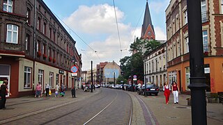
Rybnik(listen) is a city in southern Poland, in the Silesian Voivodeship. The city first developed as a fishing centre in the Middle Ages, hence the name of the city alludes to the trade. Rybnik then grew as an important centre of coal mining and the seat of the surrounding county in the 19th century.

Lubusz Voivodeship, or Lubusz Province (Polish: województwo lubuskie, is a voivodeship in western Poland.

Upper Silesia is the southeastern part of the historical and geographical region of Silesia, located mostly in Poland, with small parts in the Czech Republic.

Lower Silesian Voivodeship, or Lower Silesia Province in southwestern Poland, is one of the 16 voivodeships (provinces) into which Poland is divided. The voivodeship was created on 1 January 1999 out of the former Wrocław, Legnica, Wałbrzych and Jelenia Góra Voivodeships, following the Polish local government reforms adopted in 1998. It covers an area of 19,946 square kilometres (7,701 sq mi), and as of 2019 has a total population of 2,899,986.
The Upper Silesian metropolitan area is a metropolitan area in southern Poland and northeast Czech Republic, centered on the cities of Katowice and Ostrava in Silesia and has around 5 million inhabitans. Located in the three administrative units : mainly Silesian Voivodeship, a small western part of Lesser Poland Voivodeship and a small east part of Moravian-Silesian Region.
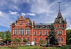
Świętochłowice(listen) is a town in Silesia in southern Poland, near Katowice. It is also the central district of the Upper Silesian Metropolitan Union metropolis, with a population of 2 million, and is located in the Silesian Highlands, on the Rawa River.

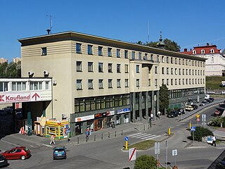
Wodzisław Śląski is a town in Silesian Voivodeship, southern Poland with 47,992 inhabitants (2019). It is the seat of Wodzisław County.

Legnica County is a unit of territorial administration and local government (powiat) in Lower Silesian Voivodeship, south-western Poland. It came into being on January 1, 1999, as a result of the Polish local government reforms passed in 1998. The county covers an area of 744.6 square kilometres (287.5 sq mi). Its administrative seat is the city of Legnica, although this city is not part of the county. The only towns in Legnica County are Chojnów and Prochowice.
Cieszyn County is a unit of territorial administration and local government (powiat) in Silesian Voivodeship, southern Poland, on the Czech and Slovak border. It came into being on January 1, 1999, as a result of the Polish local government reforms passed in 1998.

Będzin County is a unit of territorial administration and local government (powiat) in Silesian Voivodeship, southern Poland. It came into being on January 1, 1999, as a result of the Polish local government reforms passed in 1998. Its administrative seat and largest town is Będzin, which lies 13 kilometres (8 mi) north-east of the regional capital Katowice. The county contains four other towns: Czeladź, 3 km (2 mi) west of Będzin, Wojkowice, 7 km (4 mi) north-west of Będzin, Sławków, 20 km (12 mi) east of Będzin, and Siewierz, 18 km (11 mi) north-east of Będzin.
Gliwice County is a unit of territorial administration and local government (powiat) in Silesian Voivodeship, southern Poland. It came into being on January 1, 1999, as a result of the Polish local government reforms passed in 1998. Its administrative seat is the city of Gliwice, although the city is not part of the county. The county contains four towns: Knurów, 8 km (5 mi) south of Gliwice, Pyskowice, 12 km (7 mi) north of Gliwice, Toszek, 22 km (14 mi) north-west of Gliwice, and Sośnicowice, 10 km (6 mi) west of Gliwice.

Racibórz County is a unit of territorial administration and local government (powiat) in Silesian Voivodeship, southern Poland, on the Czech border. It came into being on January 1, 1999, as a result of the Polish local government reforms passed in 1998. Its administrative seat and largest town is Racibórz, which lies 58 kilometres (36 mi) west of the regional capital Katowice. The county also contains the towns of Kuźnia Raciborska, lying 16 km (10 mi) north of Racibórz, and Krzanowice, 11 km (7 mi) south-west of Racibórz.

Mikołów County is a unit of territorial administration and local government (powiat) in Silesian Voivodeship, southern Poland. It came into being on January 1, 1999, as a result of the Polish local government reforms passed in 1998. Its administrative seat and largest town is Mikołów, which lies 12 kilometres (7 mi) south-west of the regional capital Katowice. The county also contains the towns of Łaziska Górne, lying 5 km (3 mi) south-west of Mikołów, and Orzesze, 11 km (7 mi) west of Mikołów.

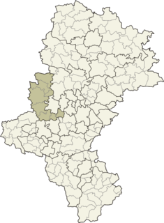
Wodzisław County is a unit of territorial administration and local government (powiat) in Silesian Voivodeship, southern Poland, on the Czech border. It came into being on January 1, 1999, as a result of the Polish local government reforms passed in 1998. Its administrative seat and largest town is Wodzisław Śląski, which lies 49 kilometres (30 mi) south-west of the regional capital Katowice. The county contains three other towns: Rydułtowy, 7 km (4 mi) north of Wodzisław Śląski, Radlin, 4 km (2 mi) north-east of Wodzisław Śląski, and Pszów, 7 km (4 mi) north-west of Wodzisław Śląski.

Bielsko County is a unit of territorial administration and local government (powiat) in Silesian Voivodeship, southern Poland. It came into being on January 1, 1999, as a result of the Polish local government reforms passed in 1998. Its administrative seat is the city of Bielsko-Biała, although the city is not part of the county. The county contains three towns: Czechowice-Dziedzice, 13 km (8 mi) north-west of Bielsko-Biała, Szczyrk, 14 km (9 mi) south of Bielsko-Biała, and Wilamowice, 12 km (7 mi) north-east of Bielsko-Biała.

Pszów is a town in Wodzisław County, Silesian Voivodeship, Poland, with 13,896 inhabitants (2019). It is located on Rybnik Plateau, in close vicinity to such cities, as Rybnik, Wodzisław Śląski, Racibórz, Radlin, Rydułtowy, Jastrzębie-Zdrój and Żory. With the area of 20.42 square kilometres (7.88 sq mi), between 1975 and 1994, Pszów was a district of Wodzisław Śląski.
Gmina Czerwionka-Leszczyny is an urban-rural gmina in Rybnik County, Silesian Voivodeship, in southern Poland. Its seat is the town of Czerwionka-Leszczyny, which lies approximately 15 kilometres (9 mi) north-east of Rybnik and 24 km (15 mi) west of the regional capital Katowice.
East Upper Silesia is the easternmost extremity of Silesia, the eastern part of the Upper Silesian region around the city of Katowice. The term is used primarily to denote those areas that became part of the Second Polish Republic on 20 June 1922, as a consequence of the post-World War I Treaty of Versailles. Prior to World War II, the Second Polish Republic administered the area as Autonomous Silesian Voivodeship. East Upper Silesia was also known as Polish (Upper) Silesia, and the German (Upper) Silesia was known as West Upper Silesia.