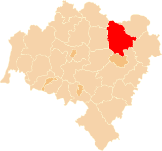
Trzebnica County is a unit of territorial administration and local government (powiat) in Lower Silesian Voivodeship, south-western Poland. It came into being on January 1, 1999, as a result of the Polish local government reforms passed in 1998. The county covers an area of 1,025.5 square kilometres (395.9 sq mi). Its administrative seat is Trzebnica, and it also contains the towns of Oborniki Śląskie, Żmigród and Prusice.

Zielona Góra County is a unit of territorial administration and local government (powiat) in Lubusz Voivodeship, western Poland. It came into being on January 1, 1999, as a result of the Polish local government reforms passed in 1998. Its administrative seat is the city of Zielona Góra, although the city is not part of the county. The county contains five towns: Sulechów, which lies 23 km (14 mi) north-east of Zielona Góra, Nowogród Bobrzański, which lies 25 km (16 mi) south-west of Zielona Góra, Babimost, which lies 40 km (25 mi) north-east of Zielona Góra, Czerwieńsk, which lies 11 km (7 mi) north-west of Zielona Góra, and Kargowa, 40 km (25 mi) north-east of Zielona Góra.

Słubice County is a unit of territorial administration and local government (powiat) in Lubusz Voivodeship, western Poland, on the German border. It came into being on January 1, 1999, as a result of the Polish local government reforms passed in 1998. Its administrative seat and largest town is Słubice, which lies 63 km (39 mi) south-west of Gorzów Wielkopolski and 79 km (49 mi) north-west of Zielona Góra. The county contains three other towns: Rzepin, lying 19 km (12 mi) east of Słubice, Ośno Lubuskie, lying 25 km (16 mi) north-east of Słubice, and Cybinka, 24 km (15 mi) south-east of Słubice.

Żagań County is a unit of territorial administration and local government (powiat) in Lubusz Voivodeship, western Poland. It came into being on January 1, 1999, as a result of the Polish local government reforms passed in 1998. Its administrative seat and largest town is Żagań, which lies 39 km (24 mi) south of Zielona Góra and 124 km (77 mi) south of Gorzów Wielkopolski. The county contains four other towns: Szprotawa, lying 14 km (9 mi) south-east of Żagań, Iłowa, lying 15 km (9 mi) south-west of Żagań, Małomice, lying 12 km (7 mi) south-east of Żagań, and Gozdnica, 25 km (16 mi) south-west of Żagań.
Nowa Sól County is a unit of territorial administration and local government (powiat) in Lubusz Voivodeship, western Poland. It came into being on January 1, 1999, as a result of the Polish local government reforms passed in 1998. Its administrative seat and largest town is Nowa Sól, which lies 22 km (14 mi) south-east of Zielona Góra and 109 km (68 mi) south of Gorzów Wielkopolski. The county contains three other towns: Kożuchów, lying 10 km (6 mi) south-west of Nowa Sól, Bytom Odrzański, lying 11 km (7 mi) south-east of Nowa Sól, and Nowe Miasteczko, 13 km (8 mi) south of Nowa Sól.

Puck County is a unit of territorial administration and local government (powiat) in Pomeranian Voivodeship, northern Poland, on the Baltic coast. The powiat of this name existed in the history of Poland, since the times of the Polish–Lithuanian Commonwealth up to 1795, and then reintroduced in 1999.

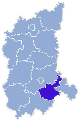
Rzeszów County is a unit of territorial administration and local government (powiat) in Subcarpathian Voivodeship, south-eastern Poland. It came into being on January 1, 1999, as a result of the Polish local government reforms passed in 1998. Its administrative seat is the city of Rzeszów, although the city is not part of the county. The county contains six towns: Dynów, 28 km (17 mi) south-east of Rzeszów, Boguchwała, 8 km (5 mi) south-west of Rzeszów, Głogów Małopolski, 16 km (10 mi) north of Rzeszów, Sokołów Małopolski, 24 km (15 mi) north of Rzeszów, Tyczyn, 8 km (5 mi) south of Rzeszów, and Błażowa, 17 km (11 mi) south-east of Rzeszów.

Płock County is a unit of territorial administration and local government (powiat) in Masovian Voivodeship, east-central Poland. It came into being on January 1, 1999, as a result of the Polish local government reforms passed in 1998. Its administrative seat is the city of Płock, although the city is not part of the county. The county contains three towns: Gąbin, 17 km (11 mi) south of Płock, Drobin, 29 km (18 mi) north-east of Płock, and Wyszogród, 39 km (24 mi) south-east of Płock.
Zgierz County is a unit of territorial administration and local government (powiat) in Łódź Voivodeship, central Poland. It came into being on January 1, 1999, as a result of the Polish local government reforms in 1998. Its administrative seat and largest town is Zgierz, which lies 9 kilometres (6 mi) north-west of the regional capital Łódź. The county contains four other towns: Ozorków, lying 16 km (10 mi) north-west of Zgierz, Aleksandrów Łódzki, lying 9 km (6 mi) south-west of Zgierz, Głowno, 24 km (15 mi) north-east of Zgierz, and Stryków, 15 km (9 mi) north-east of Zgierz.

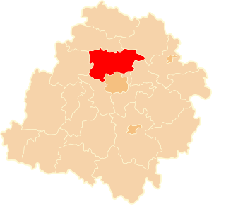
Nysa County is a unit of territorial administration and local government (powiat) in Opole Voivodeship, south-western Poland, on the Czech border. It came into being on January 1, 1999, as a result of the Polish local government reforms passed in 1998. Its administrative seat and largest town is Nysa, which lies 48 kilometres (30 mi) south-west of the regional capital Opole. The county contains four other towns: Głuchołazy, 18 km (11 mi) south of Nysa, Paczków, 24 km (15 mi) west of Nysa, Otmuchów, 12 km (7 mi) west of Nysa, and Korfantów, 20 km (12 mi) east of Nysa.

Strzelce County is a unit of territorial administration and local government (powiat) in Opole Voivodeship, south-western Poland. It came into being on January 1, 1999, as a result of the Polish local government reforms passed in 1998. Its administrative seat and largest town is Strzelce Opolskie, which lies 31 kilometres (19 mi) south-east of the regional capital Opole. The county contains four other towns: Zawadzkie, 19 km (12 mi) north-east of Strzelce Opolskie, Kolonowskie, 19 km (12 mi) north-east of Strzelce Opolskie, Leśnica, 11 km (7 mi) south-west of Strzelce Opolskie, and Ujazd, 14 km (9 mi) south-east of Strzelce Opolskie.

Opole County is a unit of territorial administration and local government (powiat) in Opole Voivodeship, south-western Poland. It came into being on January 1, 1999, as a result of the Polish local government reforms passed in 1998. Its administrative seat is the city of Opole, although the city is not part of the county. The county contains four towns: Ozimek, 20 km (12 mi) east of Opole, Niemodlin, 24 km (15 mi) west of Opole, Prószków, 11 km (7 mi) south-west of Opole, and Tułowice, 22 kilometres (14 mi) south-west of Opole.

Kędzierzyn-Koźle County is a unit of territorial administration and local government (powiat) in Opole Voivodeship, south-western Poland. It came into being on January 1, 1999, as a result of the Polish local government reforms passed in 1998. Its administrative seat and only town is Kędzierzyn-Koźle, which lies 40 kilometres (25 mi) south-east of the regional capital Opole.

Brzeg County is a unit of territorial administration and local government (powiat) in Opole Voivodeship, south-western Poland. It came into being on January 1, 1999, as a result of the Polish local government reforms passed in 1998. Its administrative seat and largest town is Brzeg, which lies 39 kilometres (24 mi) north-west of the regional capital Opole. The county also contains the towns of Grodków, lying 22 km (14 mi) south of Brzeg, and Lewin Brzeski, 17 km (11 mi) south-east of Brzeg.

Będzin County is a unit of territorial administration and local government (powiat) in Silesian Voivodeship, southern Poland. It came into being on 1 January 1999 as a result of the Polish local government reforms passed in 1998. Its administrative seat and largest town is Będzin, which lies 13 kilometres (8 mi) north-east of the regional capital Katowice. The county contains four other towns: Czeladź, 3 km (2 mi) west of Będzin, Wojkowice, 7 km (4 mi) north-west of Będzin, Sławków, 20 km (12 mi) east of Będzin, and Siewierz, 18 km (11 mi) north-east of Będzin.

Racibórz County is a unit of territorial administration and local government (powiat) in Silesian Voivodeship, southern Poland, on the Czech border. It came into being on January 1, 1999, as a result of the Polish local government reforms passed in 1998. Its administrative seat and largest town is Racibórz, which lies 58 kilometres (36 mi) west of the regional capital Katowice. The county also contains the towns of Kuźnia Raciborska, lying 16 km (10 mi) north of Racibórz, and Krzanowice, 11 km (7 mi) south-west of Racibórz.

Zawiercie County is a unit of territorial administration and local government (powiat) in Silesian Voivodeship, southern Poland. It came into being on January 1, 1999, as a result of the Polish local government reforms passed in 1998. Its administrative seat and largest town is Zawiercie, which lies 41 kilometres (25 mi) north-east of the regional capital Katowice. The county contains five other towns: Poręba, 6 km (4 mi) west of Zawiercie, Łazy, 8 km (5 mi) south of Zawiercie, Ogrodzieniec, 9 km (6 mi) south-east of Zawiercie, Szczekociny, 33 km (21 mi) north-east of Zawiercie, and Pilica, 18 km (11 mi) east of Zawiercie.

Mikołów County is a unit of territorial administration and local government (powiat) in Silesian Voivodeship, southern Poland. It came into being on January 1, 1999, as a result of the Polish local government reforms passed in 1998. Its administrative seat and largest town is Mikołów, which lies 12 kilometres (7 mi) south-west of the regional capital Katowice. The county also contains the towns of Łaziska Górne, lying 5 km (3 mi) south-west of Mikołów, and Orzesze, 11 km (7 mi) west of Mikołów.

Tarnowskie Góry County is a unit of territorial administration and local government (powiat) in Silesian Voivodeship, southern Poland. It came into being on January 1, 1999, as a result of the Polish local government reforms passed in 1998. Its administrative seat and largest town is Tarnowskie Góry, which lies 25 kilometres (16 mi) north-west of the regional capital Katowice. The county contains three other towns: Radzionków, 8 km (5 mi) south of Tarnowskie Góry, Kalety, 14 km (9 mi) north of Tarnowskie Góry, and Miasteczko Śląskie, 5 km (3 mi) north-east of Tarnowskie Góry.

Wodzisław County is a unit of territorial administration and local government (powiat) in Silesian Voivodeship, southern Poland, on the Czech border. It came into being on 1 January 1999 as a result of the Polish local government reforms passed in 1998. Its administrative seat and largest town is Wodzisław Śląski, which lies 49 kilometres (30 mi) south-west of the regional capital Katowice. The county contains three other towns: Rydułtowy, 7 km (4 mi) north of Wodzisław Śląski, Radlin, 4 km (2 mi) north-east of Wodzisław Śląski, and Pszów, 7 km (4 mi) north-west of Wodzisław Śląski.


