Cave Spring, Virginia | |
|---|---|
 Cave Spring  Cave Spring  Cave Spring | |
| Coordinates: 37°13′59″N80°0′23″W / 37.23306°N 80.00639°W | |
| Country | United States |
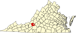
| State | Virginia |
| County | Roanoke |
| Area | |
• Total | 11.8 sq mi (30.6 km2) |
| • Land | 11.8 sq mi (30.6 km2) |
| • Water | 0.0 sq mi (0.0 km2) |
| Elevation | 1,099 ft (335 m) |
| Population (2020) | |
• Total | 26,755 |
| Time zone | UTC−5 (Eastern (EST)) |
| • Summer (DST) | UTC−4 (EDT) |
| ZIP code | 24018 |
| Area code | 540 |
| FIPS code | 51-13720 [1] |
| GNIS feature ID | 1493547 [2] |
Cave Spring is a census-designated place (CDP) in Roanoke County, Virginia, United States. The population was 26,755 at the 2020 census. Cave Spring covers much of the area known locally as "Southwest County" which has the most affluent suburbs of Roanoke. It is part of the Roanoke metropolitan area.
Contents
Roanoke County's administrative offices are in Cave Spring, though the independent city of Salem is officially the county seat.
The United States Postal Service considers most of the Cave Spring area to be unincorporated Roanoke City.