Glenvar, Virginia

Last updated
Glenvar
USA Virginia location map.svg
Red pog.svg
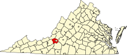
Location within the Commonwealth of Virginia
Coordinates: 37°16′26″N080°08′02″W / 37.27389°N 80.13389°W / 37.27389; -80.13389 Coordinates: 37°16′26″N080°08′02″W / 37.27389°N 80.13389°W / 37.27389; -80.13389
Country United States
State Virginia
County Roanoke
Elevation
[1]
1,089 ft (332 m)
Population
 (2010) [2]
  Total976
Time zone UTC-5 (Eastern (EST))
  Summer (DST) UTC-4 (EDT)
ZIP code
24153
Area code 540
FIPS code [2] [3] 51-31488
GNIS feature ID [1] [3] 1494959

Glenvar is a census-designated place (CDP) in western Roanoke County, Virginia, United States. The population as of the 2010 Census was 976. [4] The center of the community lies along US 11/US 460 about one mile west of the Salem city limits. [5] The community is home to Glenvar High School which serves most of the western sections of Roanoke County. As a result, the entire area of Roanoke County which is west of Salem and in the Roanoke Valley between Poor Mountain and Fort Lewis Mountain, including other communities such as Wabun, Fort Lewis, and Dixie Caverns, is often called Glenvar.

In January 2020 the Swedish truck maker Volvo announced that they would build an assembly plant for its subsidiary Mack trucks in Glenvar. The plant is expected to employ 250 people. This was reported by the Roanoke Times by Casey Fabris on 30 January 2020. However, the global pandemic of the coronavirus has halted production temporarily at all of Mack(Volvo) locations in Pennsylvania, Maryland, and Virginia.

Related Research Articles

The United States' Federal Information Processing Standards (FIPS) are publicly announced standards developed by the National Institute of Standards and Technology for use in computer systems by non-military American government agencies and government contractors.

Roanoke, Virginia Independent city in Virginia, United States

Roanoke is an independent city in the U.S. commonwealth of Virginia. As of the 2020 census, the population was 100,011, making it the 8th most populous city in Virginia and the largest city in Virginia west of Richmond. It is located in the Roanoke Valley of the Roanoke Region of Virginia.

Salem, Virginia Independent city in Virginia, United States

Salem is an independent city in the U.S. commonwealth of Virginia. As of the 2010 census, the population was 24,802. It is the county seat of Roanoke County, although the two are separate jurisdictions. The Bureau of Economic Analysis combines the city of Salem with Roanoke County, which surrounds both Salem and the neighboring City of Roanoke, for statistical purposes. Salem has its own courthouse and sheriff's office, but shares a jail with Roanoke County, which is located in the Roanoke County Courthouse complex in Salem. The Roanoke County Sheriff's Office and Roanoke County Department of Social Services are also located within Salem, though the county administrative offices are located in unincorporated Cave Spring.

Roanoke County, Virginia County in Virginia, United States

Roanoke County is a county located in the U.S. state of the Commonwealth of Virginia. As of the 2020 census, the population was 96,929. Its county seat is Salem, but the county administrative offices are located in the unincorporated Cave Spring area of the county.

Galax, Virginia Independent city in Virginia, United States

Galax is an independent city in the southwestern part of the Commonwealth of Virginia. As of the 2010 census, the population was 7,042. In 2018 the estimated population was 6,423.

Dublin, Virginia Town in Virginia, United States

Dublin is a town in Pulaski County, Virginia, United States. The population was 2,534 at the 2010 census. It is part of the Blacksburg–Christiansburg Metropolitan Statistical Area.

Roanoke metropolitan area

The Roanoke Metropolitan Statistical Area is a Metropolitan Statistical Area (MSA) in Virginia as defined by the United States Office of Management and Budget (OMB). The Roanoke MSA is sometimes referred to as the Roanoke Valley, even though the Roanoke MSA occupies a larger area than the Roanoke Valley. It is geographically similar to the area known as the Roanoke Region of Virginia, but while the latter includes Alleghany County, the former does not. As of the 2020 census, the MSA had a population of 315,251.

The Roanoke Valley in southwest Virginia is an area adjacent to and including the Roanoke River between the Blue Ridge Mountains to the east and the Appalachian Plateau to the west. The valley includes much of Roanoke County, as well as the two independent cities of Roanoke and Salem.

Poor Mountain is a ridge of high peaks located in Roanoke County, Virginia and Montgomery County, Virginia. At 3,928 feet, Poor Mountain is the tallest mountain in the immediate area.

Salem High School is a public high school in Salem, Virginia. It is the sole high school for the City of Salem public school system.

Roanoke County Public Schools is the branch of the government of Roanoke County, Virginia responsible for public K–12 education. Like all public school systems in Virginia, it is legally classified as a school division. Although it performs the functions of school districts in other U.S. states, it lacks independent taxing authority and relies on appropriations from the local government.

West Valley, New York Hamlet & CDP in New York, United States

West Valley is a hamlet in the Town of Ashford in Cattaraugus County, New York, United States. The population was 518 at the 2010 census, which lists the community as a census-designated place.

Bradshaw, Virginia Unincorporated community in Virginia, United States

Bradshaw is an unincorporated community in the northern sections of Montgomery and Roanoke counties in the U.S. state of Virginia. Bradshaw occupies a narrow valley between the north slope of Fort Lewis Mountain and the south slope of Catawba Mountain.

Glenvar High School is a public high school in Roanoke County, Virginia, United States. It is one of the five high schools for the Roanoke County public school system. Glenvar High School serves the western end of Roanoke County and is located in the community of Glenvar, which is immediately west of Salem, Virginia.

Hanging Rock, Virginia Unincorporated community in Virginia, United States

Hanging Rock is an unincorporated community in Roanoke County, Virginia, United States located directly north of Salem. The community is named for a prominent rock outcrop. The intersection of Virginia State Route 311 and Virginia State Route 419 is in Hanging Rock.

Cranberry Lake, New York hamlet & CDP in New York, United States

Cranberry Lake is a hamlet in the eastern part of the Town of Clifton, in St. Lawrence County, New York, United States. It lies along New York State Route 3 on the north shore of Cranberry Lake. The population was 200 at the 2010 census, which lists the community as a census-designated place.

The Roanoke Region is the area of the Commonwealth of Virginia surrounding the city of Roanoke. Its usage may refer to the metropolitan statistical area or the Roanoke Valley, but it sometimes includes areas in the Allegheny Mountains and New River Valley which includes Alleghany County, Montgomery County, Covington, Clifton Forge, Blacksburg, Christiansburg, and Radford. Bedford County and Floyd County are sometimes included as part of the region.

Harlow, North Dakota Unincorporated community in North Dakota, United States

Harlow is an unincorporated community in Benson County, North Dakota, United States. It is located in Butte Valley Township along North Dakota Highway 30. Harlow is assigned Zip code 58346, which it shares with neighboring Leeds.

Haram Township, Bottineau County, North Dakota Township in North Dakota, United States

Haram Township is a civil township in Bottineau County in the U.S. state of North Dakota. As of the 2000 census, its population was 85.

Calvert, Alabama Census-designated place in Alabama, United States

Calvert is an unincorporated community and census-designated place in Mobile and Washington counties, Alabama, United States. It is located in the extreme northeastern corner of the county near the Tombigbee River, along U.S. Route 43. As of the 2010 census, its population was 277.

References

  1. 1 2 "Feature Detail Report: Glenvar". Geographic Names Information System . United States Geological Survey . Retrieved August 6, 2008.
  2. 1 2 "Places: Virginia". 2010 Census Gazetteer Files. United States Census Bureau. Archived from the original on June 26, 2014. Retrieved May 9, 2014.
  3. 1 2 "FIPS55 Data: Virginia". FIPS55 Data. United States Geological Survey. February 23, 2006. Archived from the original on June 18, 2006.
  4. "Virginia Trend Report 2: State and Complete Places (Sub-state 2010 Census Data)". Missouri Census Data Center. Archived from the original on July 11, 2012. Retrieved August 6, 2008.
  5. "Glenvar, VA 24153". Google Maps. Retrieved August 6, 2008.