Riverside, Virginia

Last updated
Riverside, Virginia
Unincorporated community
Riverside, Virginia - panoramio.jpg
USA Virginia location map.svg
Red pog.svg
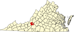
Location within the Commonwealth of Virginia
Usa edcp location map.svg
Red pog.svg
Riverside, Virginia (the US)
Coordinates: 37°14′46″N80°10′30″W / 37.24611°N 80.17500°W / 37.24611; -80.17500 Coordinates: 37°14′46″N80°10′30″W / 37.24611°N 80.17500°W / 37.24611; -80.17500
Country United States
State Virginia
County Roanoke
Elevation 1,135 ft (346 m)
Time zone Eastern (EST) (UTC-5)
  Summer (DST) EDT (UTC-4)
ZIP code 24153
Area code(s) 540
GNIS feature ID 1495131 [1]
USGS [2]

Riverside is an unincorporated community in western Roanoke County, Virginia, United States. The community lies along the Roanoke River near Dixie Caverns along U.S. 11/U.S. 460. [3] The area is more commonly referred to as Dixie Caverns instead of Riverside.

Unincorporated area Region of land not governed by own local government

In law, an unincorporated area is a region of land that is not governed by a local municipal corporation; similarly an unincorporated community is a settlement that is not governed by its own local municipal corporation, but rather is administered as part of larger administrative divisions, such as a township, parish, borough, county, city, canton, state, province or country. Occasionally, municipalities dissolve or disincorporate, which may happen if they become fiscally insolvent, and services become the responsibility of a higher administration. Widespread unincorporated communities and areas are a distinguishing feature of the United States and Canada. In most other countries of the world, there are either no unincorporated areas at all, or these are very rare; typically remote, outlying, sparsely populated or uninhabited areas.

Roanoke County, Virginia county in Virginia, United States

Roanoke County is a county located in the U.S. state of the Commonwealth of Virginia. As of the 2010 census, the population was 92,376. Its county seat is Salem.

Virginia State of the United States of America

Virginia, officially the Commonwealth of Virginia, is a state in the Southeastern and Mid-Atlantic regions of the United States located between the Atlantic Coast and the Appalachian Mountains. Virginia is nicknamed the "Old Dominion" due to its status as the first English colonial possession established in mainland North America and "Mother of Presidents" because eight U.S. presidents were born there, more than any other state. The geography and climate of the Commonwealth are shaped by the Blue Ridge Mountains and the Chesapeake Bay, which provide habitat for much of its flora and fauna. The capital of the Commonwealth is Richmond; Virginia Beach is the most populous city, and Fairfax County is the most populous political subdivision. The Commonwealth's estimated population as of 2017 is over 8.4 million.

Related Research Articles

Federal Information Processing Standards (FIPS) are publicly announced standards developed by the United States federal government for use in computer systems by non-military government agencies and government contractors.

Randolph County, Missouri county in Missouri

Randolph County is a county located in the northern portion of the U.S. state of Missouri. As of the 2010 census, the population was 25,414. Its county seat is Huntsville. The county was organized January 22, 1829 and named for U.S. Representative and U.S. Senator John Randolph of Roanoke of Virginia.

Shenandoah Valley valley and cultural region of western Virginia and the Eastern Panhandle of West Virginia in the United States

The Shenandoah Valley is a geographic valley and cultural region of western Virginia and the Eastern Panhandle of West Virginia in the United States. The valley is bounded to the east by the Blue Ridge Mountains, to the west by the eastern front of the Ridge-and-Valley Appalachians, to the north by the Potomac River and to the south by the James River. The cultural region covers a larger area that includes all of the valley plus the Virginia highlands to the west, and the Roanoke Valley to the south. It is physiographically located within the Ridge and Valley province and is a portion of the Great Appalachian Valley.

University of California, Riverside public research university

The University of California, Riverside, is a public research university in Riverside, California. It is one of the 10 general campuses of the University of California system. The main campus sits on 1,900 acres (769 ha) in a suburban district of Riverside with a branch campus of 20 acres (8 ha) in Palm Desert. In 1907 the predecessor to UCR was founded as the UC Citrus Experiment Station, Riverside which pioneered research in biological pest control and the use of growth regulators responsible for extending the citrus growing season in California from four to nine months. Some of the world's most important research collections on citrus diversity and entomology, as well as science fiction and photography, are located at Riverside.

Roanoke metropolitan area human settlement in United States of America

The Roanoke Metropolitan Statistical Area is a Metropolitan Statistical Area (MSA) in Virginia as defined by the United States Office of Management and Budget (OMB). The Roanoke MSA is sometimes referred to as the Roanoke Valley, even though the Roanoke MSA occupies a larger area than the Roanoke Valley. It is geographically similar to the area known as the Roanoke Region of Virginia, but while the latter includes Alleghany County, the former does not. As of the 2000 census, the MSA had a population of 288,309.

Stanton, Missouri community in Missouri

Stanton is an unincorporated community in southern Franklin County, Missouri, United States. It lies on Interstate 44 at the junction with Missouri Supplemental Route W, which provides access to Meramec Caverns, located approximately two miles southeast along the Meramec River.

Manns Harbor, North Carolina Census-designated place in North Carolina, United States

Manns Harbor is an unincorporated community and census-designated place (CDP) in Dare County, North Carolina, United States. As of the 2010 census it had a population of 821.

Lost Lake Resort, California Unincorporated community in California, United States

Lost Lake is a desert community located along the west shore of the Colorado River. It also lies along U.S. Route 95 near the northeast extent of Riverside County. Official U.S. Geological Survey feature ID is 245216 and NAD27 coordinates for the community are 34°00′44″N114°28′27″W. The community lies at the foot of Riverside Mountain, 34°00′49″N114°30′45″W, with a summit measuring 2,127 feet. The community is named for a lake, Lost Lake, located at 34°01′20″N114°28′21″W.

Cluster Springs, Virginia Census-designated place in Virginia, United States

Cluster Springs is an unincorporated community and census-designated place (CDP) in Halifax County, Virginia, United States. The population as of the 2010 census was 811.

Bradshaw, Virginia Unincorporated community in Virginia, United States

Bradshaw is an unincorporated community in the northern sections of Montgomery and Roanoke counties in the U.S. state of Virginia. Bradshaw occupies a narrow valley between the north slope of Fort Lewis Mountain and the south slope of Catawba Mountain.

Glenvar, Virginia Census-designated place in Virginia, United States

Glenvar is a census-designated place (CDP) in western Roanoke County, Virginia, United States. The population as of the 2010 Census was 976. The center of the community lies along US 11/US 460 about one mile west of the Salem city limits. The community is home to Glenvar High School which serves most of the western sections of Roanoke County. As a result, the entire area of Roanoke County which is west of Salem and in the Roanoke Valley between Poor Mountain and Fort Lewis Mountain, including other communities such as Wabun, Fort Lewis, and Dixie Caverns, is often called Glenvar.

Pleasant Hill, Northampton County, North Carolina Unincorporated community in North Carolina, United States

Pleasant Hill is an unincorporated community in northwestern Northampton County, North Carolina, United States. The community is on U.S. Route 301, north of Weldon, and lies at an elevation of 125 feet (38 m).

Earlysville, Virginia Unincorporated community in Virginia, United States

Earlysville is an unincorporated community in Albemarle County, Virginia, United States, roughly 9 miles (14 km) north of Charlottesville. It is named for John Early, who in 1822 bought just under 1,000 acres (4 km2) of land that now comprise a portion of the town. Earlysville has a small central business district, with a grocery store, restaurant, dentist, daycare, mechanic, and several retail stores. As of January 2019 there remains only a thrift store, an auto repair shop, a United States Post Office, and a large number of churches. There is a nearby light industrial park and several small suburban developments. The bulk of the area is rural in character.

Dixie Caverns cave in United States of America

Dixie Caverns is a commercial show cave located in the Riverside community of Roanoke County, Virginia, USA, four miles west of Salem. The cave is a limestone solution cave.

Wabun, Virginia Unincorporated community in Virginia, United States

Wabun is an unincorporated community in western Roanoke County, Virginia, United States. The community lies along the Roanoke River and near the base of Poor Mountain.

Wright, Virginia Unincorporated community in Virginia, United States

Wright is an unincorporated community in southern Roanoke County, Virginia, United States. The community lies along U.S. 220 near the Franklin County line.

Starkey, Virginia Unincorporated community in Virginia, United States

Starkey is an unincorporated community in southern Roanoke County, Virginia, United States. The community lies south of U.S. 221 near the Blue Ridge Parkway. This is the location of the Starkey School listed on the National Register of Historic Places.

Riverside, Kanawha County, West Virginia Unincorporated community in West Virginia, United States

Riverside is an unincorporated community in Kanawha County, West Virginia, United States. Riverside is located on the north bank of the Kanawha River and U.S. Route 60 1 mile (1.6 km) southeast of Glasgow.

Dixie, Baker County, Oregon Unincorporated community in Oregon, United States

Dixie is an unincorporated community in Baker County, Oregon, United States. It is along the Burnt River about 5 miles (8 km) north of Lime. Dixie was so-named because it is near the confluence of the Burnt River and Dixie Creek, which in turn was named for the many gold miners from the U.S. South who worked on the creek. Dixie post office was opened in 1913 and closed in 1924. The post office was near the railroad along the Burnt River rather than in the mining area.

Riverside, Wells County, Indiana Unincorporated community in Indiana, United States

Riverside is an unincorporated community in Harrison Township, Wells County, in the U.S. state of Indiana.

References