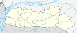
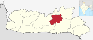
Meghalaya is a state in northeastern India. Meghalaya was formed on 21 January 1972 by carving out two districts from the state of Assam: (a) the United Khasi Hills and Jaintia Hills and (b) the Garo Hills. The population of Meghalaya as of 2014 is estimated to be 3,211,474. Meghalaya covers an area of approximately 22,430 square kilometres, with a length-to-breadth ratio of about 3:1.

Shillong is a hill station and the capital of Meghalaya, a state in northeastern India, which means "The Abode of Clouds". It is the headquarters of the East Khasi Hills district. Shillong is the 330th most populous city in India with a population of 143,229 according to the 2011 census. It is said that the rolling hills around the town reminded the British of Scotland. Hence, they would also refer to it as the "Scotland of the East".

The Khasi people are an ethnic group of Meghalaya in north-eastern India with a significant population in the bordering state of Assam, and in certain parts of Bangladesh. Khasi people form the majority of the population of the eastern part of Meghalaya, that is Khasi Hills, constituting 78.3% of the region's population, and is the state's largest community, with around 48% of the population of Meghalaya. They are among the few Austroasiatic-speaking peoples in South Asia. The Khasi tribe holds the distinction of being one of the few remaining matriarchal tribes of the world. Under the Constitution of India, the Khasis have been granted the status of Scheduled Tribe.

East Khasi Hills is an administrative district in the state of Meghalaya in India. The district headquarters are located at Shillong. The district occupies an area of 2752 km² and has a population of 825,922. As of 2011, it is the most populous district of Meghalaya's 12 districts.

Jowai is the headquarters of the West Jaintia Hills district of the state of Meghalaya, India, and is home to the Pnar, a sub-tribe of the Khasi people. It is located on a plateau surrounded on three sides by the Myntdu river bordering Bangladesh to the south. Due to its high altitude of 1365 m above sea level, Jowai experiences warm summers with cool to chilly winters.
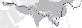
Asian Highway 1 (AH1) is the longest route of the Asian Highway Network, running 20,557 km (12,774 mi) from Tokyo, Japan via Korea, China, Southeast Asia, Bangladesh, India, Pakistan, Afghanistan and Iran to the border between Turkey and Bulgaria west of Istanbul where it joins end-on with European route E80, running all the way to Lisbon, Portugal.
The Pnar, also known as Jaiñtia, are a sub-tribal group of the Khasi people in Meghalaya, India. The Pnar people are matrilineal. They speak the Pnar Language, which belongs to the Austro-Asiatic language family and is very similar to the Khasi language. The Pnar people are natives of West Jaintia Hills and East Jaintia Hills District of Meghalaya, India. They call themselves as "Ki Khun Hynñiew Trep". Their main festivals are Behdeinkhlam, Chad Sukra, Chad Pastieh and Laho Dance.
Jaintiapur is an upazila of Sylhet District in the Division of Sylhet, Bangladesh.

Kanaighat is an upazila of Sylhet Division of Bangladesh. It is the second-largest upazila (sub-district) of Sylhet District after Gowainghat Upazila. It is named after the town of Kanaighat, which is also the only municipality in the Upazila.
Jaflong is a hill station and tourist destination in the Division of Sylhet, Bangladesh. It is located in Gowainghat Upazila of Sylhet District and situated at the border between Bangladesh and the Indian state of Meghalaya, overshadowed by subtropical mountains and rainforests. It is known for its stone collections and is home of the Khasi tribe.

The Bangladesh–India border, known locally as the Radcliffe line (IB), is an international border running between Bangladesh and India that demarcates the eight divisions of Bangladesh and the Indian states.

The Hynniewtrep National Liberation Council is a militant organization operating in Meghalaya, India. It claims to represent the Khasi-Jaintia tribal people, and its aim is to free Meghalaya from the alleged domination of outsiders from the Indian mainland. It was proscribed in India on 16 November 2000, but the ban was later lifted, before banning it again in 2019.
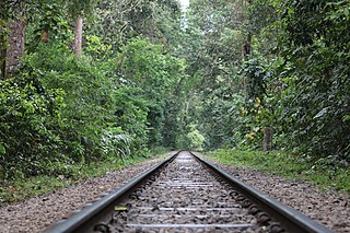
The Akhaura–Kulaura–Chhatak line is a railway line connecting Akhaura and Chhatak, via Kulaura in Bangladesh. This line is under the jurisdiction of Bangladesh Railway

Kopili River is an interstate river in Northeast India that flows through the states of Meghalaya and Assam and is the largest south bank tributary of the Brahmaputra in Assam.
West Jaintia Hills is an administrative District in the state of Meghalaya in India. The united district was created on 22 February 1972 and occupied an area of 3819 km2. It had a population of 272,185. The district is part of the Meghalaya subtropical forests eco-region. With the bifurcation of the erstwhile Jaintia Hills District into East and West Jaintia Hills Districts, West Jaintia Hills District came into existence on 31 July 2012 with its headquarters at Jowai. Jowai is the host of all the heads of important governmental offices and establishments, educational institutions, hospitals, banking institutions, etc.
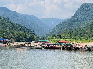
Tamabil is a hilly area in Sylhet on the border between Bangladesh and the Indian state of Meghalaya about 5 km from Jaflong.
The Republic of India shares borders with several sovereign countries; it shares land borders with China, Bhutan, Nepal, Pakistan, Afghanistan, Bangladesh and Myanmar. Bangladesh and Pakistan share both land borders as well as maritime borders, while Sri Lanka shares only a maritime border through Ram Setu. India's Andaman and Nicobar Islands share a maritime border with Thailand, Myanmar and Indonesia.

Sylhet railway station is a railway station in Bangladesh. There are two types of rail lines in Bangladesh Meter gauge and Broad gauge. This station is connected with meter-gauge link on both sides from Chhatak and Dhaka. This railway station is situated in Sylhet city.
Eastern West Khasi Hills is a district in the Indian state of Meghalaya, located approximately 25 kilometres (16 mi) west of the state capital of Shillong. It was created in 2021, after bifurcation of existing West Khasi Hills district. The territories which make up the district recorded a total population of 131,451 in the 2011 census. The district headquarters is the town of Mairang.

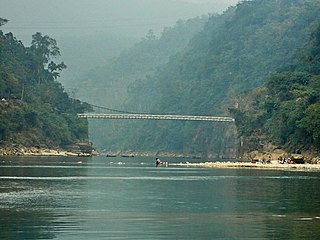
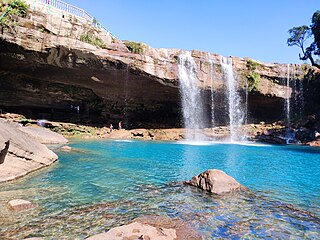
The Umngot River, also known as the Dawki River and Wah Umngot, is a river which flows through Dawki, a little town located at the bottom of the Jaintia Hills in West Jaintia Hills district in the Indian state of Meghalaya. The town is relatively busy and serves as a trade route between India and Bangladesh.