Meghalaya is a state in northeast India. Meghalaya was formed on 21 January 1972 by carving out two districts from the state of Assam: (a) the United Khasi Hills and Jaintia Hills and (b) the Garo Hills. The population of Meghalaya as of 2014 is estimated to be 3,211,474. Meghalaya covers an area of approximately 22,429 square kilometres, with a length-to-breadth ratio of about 3:1.
There is no national language in the Republic of India. However, article 343(1) of the Indian constitution specifically mentions that "The official language of the Union shall be Hindi in Devanagari script. The form of numerals to be used for the official purposes of the Union shall be the international form of Indian numerals," while clause 3 of the Official Languages Act, 1963 mentions the "Continuation of English Language for official purposes of the Union and for use in Parliament". Hence Indian English and Modern Standard Hindi are the Official Languages of the Government of India.
Chembur is an upmarket large suburb in central Mumbai, India. It belongs on the harbour line of suburban railways and offers the best connectivity with Mumbai Monorail, Santacruz- Chembur Link Road, Airport, Jeejamata Bhosle Marg, Eastern Freeway, Eastern Expressway, BKC connector, and Mumbai Satara highway (Sion-Panvel). It doesn't take much long to reach South Mumbai, Navi Mumbai, Airport, BKC, Powai, and Thane.

Northeast India (officially the North Eastern Region(NER)) is the easternmost region of India representing both a geographic and political administrative division of the country. It comprises eight states—Arunachal Pradesh, Assam, Manipur, Meghalaya, Mizoram, Nagaland and Tripura (commonly known as the "Seven Sisters"), and the "brother" state Sikkim.

Dispur is the capital of the Indian state of Assam and is a suburb of Guwahati.

Shillong is a hill station and the capital of Meghalaya, a state in northeastern India. It is the headquarters of the East Khasi Hills district. Shillong is the 330th most populous city in India with a population of 143,229 according to the 2011 census. It is said that the rolling hills around the town reminded the British of Scotland. Hence, they would also refer to it as the "Scotland of the East".

Bagdogra is a settlement in the Naxalbari CD block in the Siliguri subdivision of the Darjeeling district, in the Indian state of West Bengal. It is a part of the Greater Siliguri Metropolitan Area. The Bagdogra is well connected by air to six major cities of India – Delhi, Mumbai, Bengaluru, Hyderabad, Kolkata and Chennai through the Bagdogra Airport. The Bagdogra railway station is also well connected.

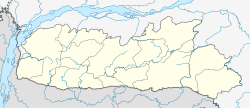
Ri Bhoi is an administrative district in the state of Meghalaya in India. The district headquarters are located at Nongpoh. The district occupies an area of 2378 km² and has a population of 258,840. As of 2011 it is the second least populous district of Meghalaya, after South Garo Hills.

Nongpoh is the administrative centre of Ri-Bhoi district in the Indian state of Meghalaya in the Republic of India. Nongpoh is located on National Highway 40, fifty-two kilometers from the state capital Shillong and forty-eight kilometers from Guwahati in the state of Assam.
Supaul is a town and a municipality that is headquarters of Supaul district in the Indian state of Bihar. Supaul is the administrative headquarters of this district.
The administrative divisions of India are subnational administrative units of India; they are composed of a nested hierarchy of administrative divisions.

Ambala Cantonment is a cantonment town in Ambala district in the state of Haryana, India. It is 200 km north of Delhi and 55 km southwest of Chandigarh. This cantonment was established in the year 1843 and is an important centre for manufacturing of scientific and surgical instruments.

Barauni is an Industrial City situated on the bank of the river Ganges in the Begusarai district in the state of Bihar, India. It lies north of the Ganges (Ganga) River and is part of the Begusarai urban agglomeration.
Kerakat or Kirakat is a town and nagar panchayat in Jaunpur district of the Indian state of Uttar Pradesh with a population of approximately 13,500. It is situated near the Gomati River, which helps the land around the town stay very fertile. Kerakat or Kirakat forms a part of Varanasi Division. It is located 30 km east of the city of Jaunpur and 279 km from Lucknow, the capital of Uttar Pradesh.
Banga is a town and Municipal council in the Shahid Bhagat Singh Nagar district of Punjab, India. Banga is also one of the sub-division (tehsil) headquarters of the district. Banga located on Phagwara-Rupnagar section of National Highway 344A. It is currently estimated to have a population of about 23,000 and is classified as a class 2 Municipality. The town also incorporates the former village of Jindowal apart from Banga town.
Vasind is a city in Shahapur taluka of Thane district in the Indian state of Maharashtra. It is suburban city of Mumbai.Mumbai-Vasind distance is about 63.1 km. Vashind is a census town.
Lambhua is a town, tehsil, and a Nagar panchayat in Sultanpur district in the Indian state of Uttar Pradesh. It is located on the National Highway 731.
National Highway 217 commonly referred to as NH 217, is a national highway in India. This route was earlier part of old national highways 51 and 62. It is a secondary route of National Highway 17. NH-217 runs through the states of Assam and Meghalaya in India.

Kamjong District is a district in Manipur state, India created by splitting Ukhrul district.
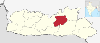
Eastern West Khasi Hills is a district in the Indian state of Meghalaya, located approximately 25 kilometres (16 mi) west of the state capital of Shillong. It was created in 2021, after bifurcation of existing West Khasi Hills district. The territories which make up the district recorded a total population of 131,451 in the 2011 census. The district headquarters is the town of Mairang.