
Nankana Sahib is a city and capital of Nankana Sahib District in the Punjab province of Pakistan. It is named after the first Guru of the Sikhs, Guru Nanak, who was born in the city and first began preaching here. Nankana Sahib is the most important religious site for the Sikh religion. It is located about 91 km (57 mi) west of Lahore and about 75 km (47 mi) east of Faisalabad. According to the census of 2017 the city has a population of 110,135 inhabitants. Until 2005, it was a part of the Sheikhupura District.
The Battle of Longewala was one of the first major engagements in the western sector during the Indo-Pakistani War of 1971, fought between assaulting Pakistani forces and Indian defenders at the Indian border post of Longewala, in the Thar Desert of Rajasthan. The battle was fought between 120 Indian soldiers accompanied by four Hunter fighter aircraft and 2,000–3,000 Pakistani soldiers accompanied by 30–40 tanks.

Pokhran is a town and a municipality located 112 km east of Jaisalmer city in the Jaisalmer district of the Indian state of Rajasthan. It is situated in the Thar Desert region. Surrounded by rocks, sand and five salt ranges, the word "Pokaran" (पोकरण) means "place surrounded by five salt-ranges" in Rajasthani. The site for India's first and second underground nuclear weapon test is near Pokhran.

Jaisalmer, nicknamed "The Golden city", is a city in the Indian state of Rajasthan, located 575 kilometres (357 mi) west of the state capital Jaipur. It is the administrative headquarters of Jaisalmer District. Before Indian independence, the town served as the capital of the Jaisalmer State, ruled by the Bhati Rajputs. Jaisalmer stands on a ridge of yellowish sandstone and is crowned by the ancient Jaisalmer Fort. This fort contains a royal palace and several ornate Jain temples. Many of the houses and temples of both the fort and of the town below are built of finely sculptured yellow sandstone. The town lies in the heart of the Thar Desert and has a population, including the residents of the fort, of about 78,000. Jaisalmer ranked 9th on Booking.com's Top 10 The Most Welcoming cities in the world. The only indian city to make in the list.

Jind district is one of the 22 districts of Haryana state in northern India. Jind town is the administrative headquarters of the district. It is part of Hisar Division and was created in 1966.

Barmer District is a district in Rajasthan state of India. It is located in the western part of Rajasthan state forming a part of the Thar Desert. Barmer is the third largest district by area in Rajasthan and fifth largest district in India. Occupying an area of 28,387 km2. Being in the western part of the state, it includes a part of the Thar Desert. Jaisalmer is to the north of this district while Jalore is in its south. Pali and Jodhpur form its eastern border and it shares a border with Pakistan in the west. Partially being a desert, this district has a large variation in temperature. The temperature in summer can rise up to 51 °C and falls near to 0 °C in winter. Luni is the longest river in Barmer district. After travelling a length of almost 500 km, it passes through Jalore and merges in the marshy land of Runn of Kutch. District headquarters is in the town of Barmer. The other major towns in the district are: Balotra, Guda Malani, Baytoo, Siwana, and Chohatan. Recently, a large onshore oil field has been discovered and made functional in Barmer district. Barmer is also famous for pomegrante.
Ranchore Line, officially named as Gazdarabad, is a neighbourhood in the Karachi South district of Karachi, Pakistan. The neighborhood is one of the oldest in Karachi, and has a predominantly Muslim Marwaris population who hailed from Jaisalmer in Rajasthan from 19th century. Gazadarabad is also home to Karachi's largest Hindu-dominated neighborhood, Narayan Pura.

Jaisalmer district is the largest district in the Indian state of Rajasthan, and the third largest district in India. Located in Marwar, the city of Jaisalmer is the administrative headquarters of the district. It is around 289 km (180 mi) from the city of Jodhpur, and around 559 km (347 mi) from Jaipur, the capital of Rajasthan. As of the 2011 population census, it is the least populous district out of all 33 districts in Rajasthan.

Jaisalmer Fort is situated in the city of Jaisalmer, in the Indian state of Rajasthan. It is one of the very few "living forts" in the world, as nearly one fourth of the old city's population still resides within the fort. For the better part of its 860-year history, the fort was the city of Jaisalmer. The first settlements outside the fort walls, to accommodate the growing population of Jaisalmer, are said to have come up in the 17th century.
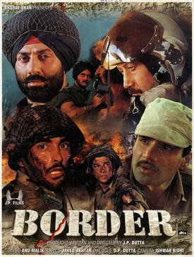
Border is a 1997 Indian Hindi-language epic war film written, produced and directed by J. P. Dutta. Set during the Indo-Pakistani War of 1971, it is an adaptation of real life events that happened during the Battle of Longewala in 1971. The film stars an ensemble cast of Sunny Deol, Jackie Shroff, Sunil Shetty, Akshaye Khanna, Sudesh Berry, Puneet Issar and Kulbhushan Kharbanda. Tabu, Raakhee, Pooja Bhatt and Sharbani Mukherjee feature in supporting roles.
Phalodi is a city in Phalodi district in the Indian state of Rajasthan. It is the headquarters for Phalodi District. Phalodi is also called the "salt city" due to the salt industry in Rin. Phalodi is in the buffer zone of Thar Desert and often subject to extreme temperature conditions due to its arid climate. It holds the record for the highest verified temperature recorded in Rajasthan at 51.0 °C (123.8 °F) on 19 May 2016. It is also the highest temperature ever recorded in India.
Ratannagar is a city, near Churu city, and a municipality in Churu district in the Indian state of Rajasthan. Ratannagar is a small town in the Churu District in the State of Rajasthan, India. It is situated about 8 kilometers south of Churu and has a population of approximately 14,000 people. It is located on the Jaipur road and is famous for its havelis. In 1982, Director J.P. Dutta made a motion picture in the village entitled "Gulami", starring Dharmendra, Mithun, Nasirudin Shah, Kulbhushan Kharbanda, Smita Patil, Anita Raj and Rina Rai. The main reason the small town was used for the month-long shooting was the noted havelis.

Tanot Mata is a temple in the western state of India in District Jaisalmer of Rajasthan.
Sanu railway station is a small railway station in Jaisalmer district, Rajasthan. Its code is SANU. It serves Sanu town. The station is consists of two platforms. The station is the terminal on Jaisalmer–Sanu line and last Indian station in Jaisalmer district towards Pakistan. This station is for transport of limestone. There is no passenger train scheduled for this station.

Kuldhara is an abandoned village in the Jaisalmer district of Rajasthan, India. Established around the 13th century, it was once a prosperous village inhabited by Paliwal Brahmins. It was abandoned by the early 19th century for unknown reasons, possibly because of dwindling water supply, an earthquake, or as a local legend claims, because of the atrocities by the Jaisalmer State's minister Salim Singh.

Nachna village and a Panchayat committee located in Pokhran tehsil of Jaisalmer district in Rajasthan, India. It is situated 85km away from sub-district headquarter Pokaran and 120km away from district headquarter Jaisalmer. it's famous for, the march of the desert.
Phalodi Junction railway station is a railway station in Jodhpur district, Rajasthan. Its code is PLCJ. It serves Phalodi town. The station consists of three platforms. Passenger, Express, and Superfast trains halt here.

75 Armoured Regiment is an armoured regiment of the Indian Army.
Mokla is a village located in Jaisalmer district of the Indian state of Rajasthan.
Abhainagar is a village located in the Jaisalmer district of the Indian state of Rajasthan. It is located in Jaisalmer tehsil. It is situated 22 km east of the district headquarters in Jaisalmer, and 546 km away from the capital Jaipur.


