Golokganj

Last updated

Golokganj
town
India Assam location map.svg
Red pog.svg
Golokganj
Location in Assam, India
India location map.svg
Red pog.svg
Golokganj
Golokganj (India)
Coordinates: 26°06′N89°50′E / 26.10°N 89.83°E / 26.10; 89.83
CountryFlag of India.svg  India
State Assam
District Dhubri
Elevation
58 m (190 ft)
Population
 (2011)
  Total16,000
Languages
  Official Assamese
Time zone UTC+5:30 (IST)
ISO 3166 code IN-AS
Vehicle registration AS

Golokganj (also spelt as Golakganj or Galakganj) is a census town in Dhubri district in the Indian state of Assam. Golakganj is one of the historical places of Dhubri district.

Contents

Geography

Gangadhar River at NH31 near Golokganj Gangadhar River.JPG
Gangadhar River at NH31 near Golokganj

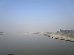
Golakganj is located at 26°06′N89°50′E / 26.10°N 89.83°E / 26.10; 89.83 . [1] It has an average elevation of 45 m (148 ft). Golakganj is situated 20 km from the district headquarters. Golakganj is situated on the east bank of Gangadhar River and the Indo-Bangladesh border is almost 5 km. away from heart of the place. Golakganj is the prime commercial place of its adjacent towns and villages. The soil of this place is very fertile.

Demographics

As of 2001 India census, [2] Golokganj had a population of 7612. Males constitute 54% of the population and females 46%. Golokganj has an average literacy rate of 63%, higher than the national average of 59.5%: male literacy is 69%, and female literacy is 55%. In Golokganj, 13% of the population is under 6 years of age. Commonly spoken language is Goalparia.

Transport

There is an old railway-cum-road bridge (unused) constructed by the British government in 1901 under the inspection of British Engineers. Golokganj railway station is situated in the heart of Golakganj town which was constructed before the East Bengal Partition of 1905 by the British. There is the facility for online reservation of railway tickets. Railway services were resumed from 2011 and currently daily intercity trains between Guwahati and Dhubri, between Siliguri and Dhubri, another between Bongaigaon and New Jalpaiguri are plying. Also a tri weekly train between Silghat in Nagaon and Alipurduar in West Bengal are plying.Nearest airport named Rupsi airport is 15 km away from Golakganj town. Buses from Coochbehar and Siliguri are well connected from Golakganj town.

Education

There is an arts college named Chilarai College which was established in the year 1973.Now this college is upgraded to university and first university in dhubri district is going to held in golakganj town.There is a Basic Training Centre (TC) and a DIET centre, imparting professional training to fresh and in-service teachers. Physical infrastructure of a proposed Industrial Training Institute (ITI) had already been created and classes would be starting soon. There is a girls residential school Kasturba Gandhi Balika Vidayala. Further there is Chinmoi High School, Jagamohan Vidypeeth Higher Secondary School, Sankardeva Sishu Niketan, and Jatiyo Vidyalaya. Moreover, there is a Madrassa (Islamic Institution of education) named Rahamatganj Senior Madrassa which is the only institution of higher education for the Muslims of the place of Western Assam.

industry

Shopping Malls

Politics

Golakganj is part of Dhubri (Lok Sabha constituency). [3] The name of the constituency of Golakganj is 25th Golakganj LAC. Present MLA of Golakganj LAC is Shri. Abdus Sobahan Ali Sarkar form the INC.

§ Intentional Trade Center: Government of India recently started Intentional Trade Center at Lakhimari (the Indo-Bangladesh border) which is situated on the west bank of Gangadhar River and about 4 km from Golakganj Town.

Related Research Articles

<span class="mw-page-title-main">Dhubri district</span> District of Assam in India

Dhubri District (Pron:ˈdʊbri) is an administrative district in the Indian state of Assam. The district headquarters are located at Dhubri town which is situated ~290 km from Guwahati. This was also the headquarters of erstwhile undivided Goalpara district which was created in 1876 by the British government. In 1983, Goalpara district was divided into four districts and Dhubri is one among those. Dhubri district is one among the many Muslim-majority districts of Assam. In 2016, Dhubri was divided again to form South Salmara-Mankachar District.

<span class="mw-page-title-main">Diphu</span> Town in Assam, India

Diphu is the headquarter of Karbi Anglong district in the state of Assam in India. This small town is a popular tourist hill station for people of nearby cities.

<span class="mw-page-title-main">Barpeta</span> Town in Assam, India

Barpeta is a town in Barpeta district of the state of Assam in India and is district headquarters. The city is located 90 kilometres (56 mi) north west of Guwahati and is one of the major cities in Western Assam. It is also called Satra Nagari of Assam due to the presence of various Vaishnavite Satras in the vicinity.

<span class="mw-page-title-main">Dhubri</span> Town in Assam, India

Dhubri is a town and the administrative centre of Dhubri district in the Indian state of Assam. It is an old town on the bank of the Brahmaputra river, with historical significance. In 1883, the town was first constituted as a Municipal Board under the British regime. It is situated about 277.4 kilometres (172 mi) west from Dispur, the state capital of Assam.

Gauripur is a semi-urban town under Gauripur Town Committee in the Dhubri district in the state of Assam, India.

Gossaigaon is one of the fastest-developing towns and the hometown of the state's youngest Raimona National Park in the Bodoland region of Assam, India. This is a sub-divisional headquarter of Kokrajhar district. It shares its boundaries with the neighboring state of West Bengal in the west and Dhubri district to the south. It is one of the BTR's proposed districts. Gossaigaon is well connected by ground transportation and rails. The town serves as a direct route by road to the state's youngest Rupsi Airport located in the southernmost part of the town. Madati and Sankosh are some of the prominent rivers that flow through the heart of the town, and forested areas include such saleable trees as Shorea robusta (sal), Tectona grandis (teak). This place practices organic farming as well as modern agriculture, following recent scientific developments.

<span class="mw-page-title-main">North Lakhimpur</span> Town in Assam, India

North Lakhimpur is a city and a municipal board in Lakhimpur district in the Indian state of Assam, about 394 kilometres (245 mi) northeast of Guwahati. It is the district headquarters of Lakhimpur district.

<span class="mw-page-title-main">Titabor</span> Town in Assam, India

Titabor or Titabar is a town in the Jorhat district of Assam in India. It is about 20 km away from Jorhat City. It is one of the highly greeny places of Assam almost surrounded by different tea-estates. The town serves as the administrative headquarters of the Thengal Kachari Autonomous Council.

<span class="mw-page-title-main">Tufanganj</span> Subdivisional Town in West Bengal, India

Tufanganj is a town and a municipality of Cooch Behar district in the Indian state of West Bengal. It is the headquarters of the Tufanganj subdivision.

<span class="mw-page-title-main">Lakhiganj</span> Village in Assam, India

Lakhiganj is a village, a small Bazaar (market), a post office and a Gaon Panchayat in the Dhubri district of Assam, around 8 km north from Bilasipara,. It is situated on the Bilasipara-Kokrajhar state highway, around 12 km from Kokrajhar town and 9 km from Fakiragram railway station. The bazaar hosts weekly market on Monday and Friday. It has a small township comprising people of different backgrounds and as such they represent a mixed culture. The people of this Bazzar area basically speak Goalpariya, Assamese, although Marawari, Bihari and Bengalis’ are also there. The people are primarily dependent on small-scale business. However, it is surprising that this the place where Motram Surajmal Dugar first established a small firm in 1906 and now it is a big business house, named "the MS Dugar group of companies" operate all over India.

Fakiragram is a railway station on the New Jalpaiguri–New Bongaigaon section of Barauni–Guwahati line and is located in Kokrajhar district in the Indian state of Assam. A branch line from Fakiragram connects to Dhubri.

<span class="mw-page-title-main">New Jalpaiguri–New Bongaigaon section</span> Railway line in India

The New Jalpaiguri–New Bongaigaon section of the Barauni–Guwahati line connects New Jalpaiguri in the Indian state of West Bengal and New Bongaigaon in Assam.

Bamanhat railway station serves the town of Bamanhat lying in Alipurduar–Bamanhat branch line, Cooch Behar district in the Indian state of West Bengal. The station is part of Alipurduar railway division of Northeast Frontier Railway zone.

Golakganj is a railway junction station on the Fakiragram–Dhubri branch line and the New Cooch Behar–Golakganj branch line. A new line is being laid to connect Golakganj with Jogighopa. It is located in Dhubri district in the Indian state of Assam. This station serves the Golakganj town. Important trains like Alipurduar–Silghat Town Rajya Rani Express, Siliguri–Dhubri Intercity Express are available from this station.

<span class="mw-page-title-main">Dhubri railway station</span> Indian railway station in Assam

Dhubri is the terminal railway station on the Fakiragram–Dhubri branch line. It also links to the New Cooch Behar–Golokganj branch line. A new line is being laid to connect Dhubri with Jogighopa. It is located on the west bank of the Brahmaputra in Dhubri district in the Indian state of Assam. Important trains like Alipurduar–Silghat Town Rajya Rani Express, Siliguri–Dhubri Intercity Express are available from Dhubri. It lies under Alipurduar railway division of Northeast Frontier Railway zone.

Agomani is a sub town area of Dhubri district (Assam) India. It is an area on the bank of Gangadhar River with historical significance. Agomani stands in a rural area, but it is not a revenue village. Some portions of the village of Kaldoba and Shernagar and total number of 41 villages in block formed the big area of Agomani. The area of Agomani is about 214 km2 Agomani is situated at a distance of 50 km to the North West of Dhubri, 12 km to the South of West Bengal border and 8 km to the North East of Bangladesh border. National Highway 17 passes through Agomani from North to South and the historical Gohain Kamal Ali (Road) runs from East to West. Both the roads crossed it the heart of Agomani. At the conjunction, there is a daily market and shops of all kinds are established. In 1963 a terrible Cyclone blew over Agomani and swept away many houses, lives and properties and the name of Agomani appeared on Newspaper, Radio & T.V and Agomani had been known to all over Assam.

<span class="mw-page-title-main">South Salmara-Mankachar district</span> District of Assam in India

South Salmara-Mankachar is an administrative district in the state of Assam in India. The district headquarter is located at Hatsingimari village which is situated at about 245 km from Guwahati. It was earlier a sub-division of the Dhubri District.

The 15765 / 66 Siliguri Junction - Dhubri Intercity Express is an Express train belonging to Indian Railways Northeast Frontier Railway zone that runs between Siliguri Junction of West Bengal and Dhubri of Assam in India.

Bakshirhat is a neighbourhood in the Tufanganj II CD block in the Tufanganj subdivision of the Cooch Behar district in the state of West Bengal, India.

The New Mal–Changrabandha–New Cooch Behar line are a set of 2 lines which connect Changrabandha, a border transit point near Indo-Bangladesh border in Cooch Behar district with the stations of New Mal in Jalpaiguri district and New Cooch Behar in Cooch Behar district of West Bengal. It is under the jurisdiction of Northeast Frontier Railway. The Malbazar–Changrabandha section of the line was a metre-gauge line, before its gauge conversion began on 2002. The Malbazar–Changrabandha section was re-opened to public on 20 January 2016 after gauge conversion. The New Changrabandha–New Cooch Behar broad-gauge line was built as an extension as a part of the New Maynaguri–Jogighopa rail line to provide an alternate link from North Bengal to Assam and was opened to public on 21 February 2016.

References

  1. Falling Rain Genomics, Inc - Golakganj
  2. "Census of India 2001: Data from the 2001 Census, including cities, villages and towns (Provisional)". Census Commission of India. Archived from the original on 16 June 2004. Retrieved 1 November 2008.
  3. "List of Parliamentary & Assembly Constituencies" (PDF). Assam. Election Commission of India. Archived from the original (PDF) on 4 May 2006. Retrieved 5 October 2008.