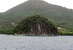
Columnar jointing of volcanic rocks exists in many places on Earth. Perhaps the most famous basalt lava flow in the world is the Giant's Causeway in Northern Ireland, in which the vertical joints form polygonal columns and give the impression of having been artificially constructed.
In India, columnars are found in several places across the volcanic traps such as 6.5 crore or 65 million years ago (Mya) old deccan traps in South India and 14.5 crore or 145 mya old Rajmahal Traps in Eastern India.
Several exposures of columnar jointing have been discovered on the planet Mars by the High Resolution Imaging Science Experiment (HiRISE) camera, which is carried by the Mars Reconnaissance Orbiter (MRO). Notable among them are formations in the Marte Vallis. [37]
A likely Hindu-origin ancient site at Gunung Padang in West Java, Indonesia was built by horizontally laying basalt columns to form terraces on the slope of a hill and creating open-roofed chambers by erecting vertical columns. A now-ruined thirteenth-century religious complex called Nan Madol was built using columnar basalt quarried from various locations on the island of Pohnpei in Micronesia.
Hexagonal basalt was used to build retaining walls by early settlers in some places around Dunedin in New Zealand.
Staffa is an island of the Inner Hebrides in Argyll and Bute, Scotland. The Vikings gave it this name as its columnar basalt reminded them of their houses, which were built from vertically placed tree-logs.
In geography and geology, a cliff is an area of rock which has a general angle defined by the vertical, or nearly vertical. Cliffs are formed by the processes of weathering and erosion, with the effect of gravity. Cliffs are common on coasts, in mountainous areas, escarpments and along rivers. Cliffs are usually composed of rock that is resistant to weathering and erosion. The sedimentary rocks that are most likely to form cliffs include sandstone, limestone, chalk, and dolomite. Igneous rocks such as granite and basalt also often form cliffs.
Devils Postpile National Monument is a U.S. National Monument located near Mammoth Mountain in Eastern California. The monument protects Devils Postpile, an unusual rock formation of columnar basalt, "all closely and perfectly fitted together like a vast mosaic." The monument encompasses 798 acres (323 ha) and includes two main attractions: the Devils Postpile formation and Rainbow Falls, a waterfall on the Middle Fork of the San Joaquin River. In addition, the John Muir Trail and Pacific Crest Trail merge into one trail as they pass through the monument. Excluding a small developed area containing the monument headquarters, visitor center and a campground, the National Monument lies within the borders of the Ansel Adams Wilderness.
Quảng Ninh or Quangninh is a province along the northeastern coast of Vietnam. It is about 153 km (95 mi) east of Hanoi, comprising four cities, two district-level towns and seven rural districts. The provincial capital is Hạ Long. The province covers an area of 6,207.95 km2 (2,396.90 sq mi) and, as of 2023, had a population of 1,413,452. Nearly 80% of the province is mountainous with abundant land, forest, water and mineral resources, with 90% of Vietnam's coal output extracted from the province. The province is also home to Hạ Long Bay, a World Heritage Site that has 1,969 islands, out of which 989 have been given names.
Latourell Falls is a waterfall along the Columbia River Gorge in the U.S. state of Oregon, within Guy W. Talbot State Park.
Phú Yên is a central coastal province in the South Central Coast region, in Central Vietnam. It borders Bình Định to the north, Khánh Hòa to the south, Gia Lai to the northwest, Đắk Lắk to the southwest and the East Sea to the east.
Trap rock, also known as either trapp or trap, is any dark-colored, fine-grained, non-granitic intrusive or extrusive igneous rock. Types of trap rock include basalt, peridotite, diabase, and gabbro. Trap is also used to refer to flood (plateau) basalts, such as the Deccan Traps and Siberian Traps. The erosion of trap rock created by the stacking of successive lava flows often creates a distinct stairstep landscape from which the term trap was derived from the Swedish word trappa, which means "stairway".
The geology of the Pacific Northwest includes the composition, structure, physical properties and the processes that shape the Pacific Northwest region of North America. The region is part of the Ring of Fire: the subduction of the Pacific and Farallon Plates under the North American Plate is responsible for many of the area's scenic features as well as some of its hazards, such as volcanoes, earthquakes, and landslides.
North Mountain is a narrow southwest-northeast trending volcanic ridge on the mainland portion of southwestern Nova Scotia, stretching from Brier Island to Cape Split. It forms the northern edge of the Annapolis Valley along the shore of the Bay of Fundy. Together with South Mountain, the two ranges form the Annapolis Highlands region.
Taaw Tldáaw, formerly known as Tow Hill, is a large isolated volcanic plug located 21 km (13 mi) east of Masset on the north end of the Naikoon Peninsula of northeast Graham Island in Haida Gwaii, British Columbia, Canada, east of McIntyre Bay and near the mouth of the Hiellen River, which is the site of Hiellen, a now-abandoned Haida village and of the Hiellen Indian Reserve No. 2, on the site of that village. Formerly Tow Hill Provincial Park, it is now part of Naikoon Provincial Park, which covers most of the northeastern flatland of Graham Island.
Columnar jointing is a geological structure where sets of intersecting closely spaced fractures, referred to as joints, result in the formation of a regular array of polygonal prisms, or columns. Columnar jointing occurs in many types of igneous rocks and forms as the rock cools and contracts. Columnar jointing can occur in cooling lava flows and ashflow tuffs (ignimbrites), as well as in some shallow intrusions. Columnar jointing also occurs rarely in sedimentary rocks, due to a combination of dissolution and reprecipitation of interstitial minerals by hot, hydrothermal fluids and the expansion and contraction of the rock unit, both resulting from the presence of a nearby magmatic intrusion.
Tuy An is a district (huyện) of Phú Yên province in the South Central Coast region of Vietnam.
The Sheepeater Cliffs are a series of exposed cliffs made up of columnar basalt in Yellowstone National Park in the United States. The lava was deposited about 500,000 years ago during one of the periodic basaltic floods in Yellowstone Caldera, and later exposed by the Gardner River. The cliffs are noted as a textbook example of a basaltic flow with well defined joints and hexagonal columns. They were named after a band of Eastern Shoshone known as Tukuaduka. Many of the exposed cliffs are located along a steep inaccessible canyon cut by the Gardner near Bunsen Peak, but some of the cliffs located just off the Grand Loop Road can be reached by car.
The Mess Lake Lava Field is a volcanic field associated with the Mount Edziza volcanic complex of the Northern Cordilleran Volcanic Province in northwestern British Columbia, Canada. It lies northwest of the Spectrum Range on the Kitsu Plateau and consists of young basaltic lava flows and tephra. The source for the basaltic lava and tephra was three cinder cones, including Mess Lake Cone and The Ash Pit, which may be the youngest volcanic feature of the Mount Edziza volcanic complex.
The Canadian Cascade Arc, also called the Canadian Cascades, is the Canadian segment of the North American Cascade Volcanic Arc. Located entirely within the Canadian province of British Columbia, it extends from the Cascade Mountains in the south to the Coast Mountains in the north. Specifically, the southern end of the Canadian Cascades begin at the Canada–United States border. However, the specific boundaries of the northern end are not precisely known and the geology in this part of the volcanic arc is poorly understood. It is widely accepted by geologists that the Canadian Cascade Arc extends through the Pacific Ranges of the Coast Mountains. However, others have expressed concern that the volcanic arc possibly extends further north into the Kitimat Ranges, another subdivision of the Coast Mountains, and even as far north as Haida Gwaii.
The Mount Cayley volcanic field (MCVF) is a remote volcanic zone on the South Coast of British Columbia, Canada, stretching 31 km (19 mi) from the Pemberton Icefield to the Squamish River. It forms a segment of the Garibaldi Volcanic Belt, the Canadian portion of the Cascade Volcanic Arc, which extends from Northern California to southwestern British Columbia. Most of the MCVF volcanoes were formed during periods of volcanism under sheets of glacial ice throughout the last glacial period. These subglacial eruptions formed steep, flat-topped volcanoes and subglacial lava domes, most of which have been entirely exposed by deglaciation. However, at least two volcanoes predate the last glacial period and both are highly eroded. The field gets its name from Mount Cayley, a volcanic peak located at the southern end of the Powder Mountain Icefield. This icefield covers much of the central portion of the volcanic field and is one of the several glacial fields in the Pacific Ranges of the Coast Mountains.
Hong Kong UNESCO Global Geopark, formerly Hong Kong National Geopark (香港國家地質公園), was inaugurated on 3 November 2009. It is a single entity of land area over 150 km2 across parts of the eastern and northeastern New Territories. On 18 September 2011, UNESCO listed the geopark as part of its Global Geoparks Network.
Cape Raoul is a rural locality and a natural feature in the local government area of Tasman in the South-east region of Tasmania. It is located about 13 kilometres (8.1 mi) south of the town of Nubeena. The 2016 census determined a population of nil for the state suburb of Cape Raoul.
Gành Đá Đĩa or Ghềnh Đá Đĩa is a seashore area of uniformly interlocking basalt rock columns located along the coast in An Ninh Dong Commune, Tuy An District, Phu Yen Province, Vietnam.