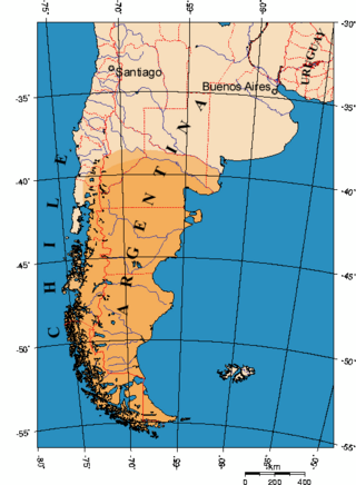
Patagonia is a geographical region that encompasses the southern end of South America, governed by Argentina and Chile. The region comprises the southern section of the Andes Mountains with lakes, fjords, temperate rainforests, and glaciers in the west and deserts, tablelands and steppes to the east. Patagonia is bounded by the Pacific Ocean on the west, the Atlantic Ocean to the east, and many bodies of water that connect them, such as the Strait of Magellan, the Beagle Channel, and the Drake Passage to the south.

Chubut is a province in southern Argentina, situated between the 42nd parallel south, the 46th parallel south, the Andes range to the west, and the Atlantic ocean to the east. The province's name derives from the Tehuelche word chupat, meaning "transparent," their description of the Chubut River.

Mendoza, officially the City of Mendoza is the capital of the province of Mendoza in Argentina. It is located in the northern-central part of the province, in a region of foothills and high plains, on the eastern side of the Andes. As of the 2010 census [INDEC], Mendoza had a population of 115,041 with a metropolitan population of 1,055,679, making Greater Mendoza the fourth largest census metropolitan area in the country.

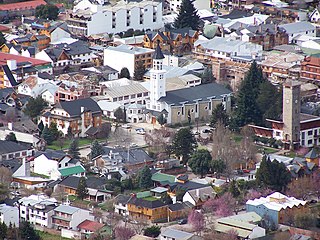
San Carlos de Bariloche, usually known as Bariloche, is a city in the province of Río Negro, Argentina, situated in the foothills of the Andes on the southern shores of Nahuel Huapi Lake. It is located within the Nahuel Huapi National Park. After development of extensive public works and Alpine-styled architecture, the city emerged in the 1930s and 1940s as a major tourism centre with skiing, trekking and mountaineering facilities. In addition, it has numerous restaurants, cafés, and chocolate shops. The city had a permanent population of 108,205 according to the 2010 census. According to the latest statistics from 2015, the population is around 122,700, and a projection for 2020 estimates 135,704.
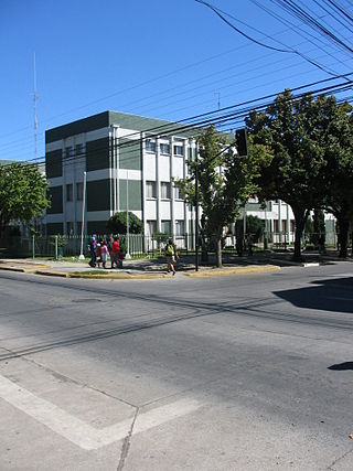
Los Ángeles is the capital of the province of Bío Bío, in the commune of the same name, in Bío Bío, in the center-south of Chile. It is located between the Laja and Biobío rivers. The population is 186,671 inhabitants. The municipality ("comuna") of Los Ángeles has the highest absolute rural population of any Chilean municipality.

The Trans-Andean railways provide rail transport over the Andes. Several are either planned, built, defunct, or waiting to be restored. They are listed here in order from north to south.
San Martín de los Andes is a city in the south-west of the province of Neuquén, Argentina, serving as the administration centre of the Lácar Department. Lying at the foot of the Andes, on the Lácar lake, it is considered one of the main tourism destinations in the province. The National Route 40 runs to the city, connecting it with important touristic points in the south of the province, such as Lanín and Nahuel Huapí national parks.

The Transandine Railway was a 1,000 mmmetre gauge combined rack and adhesion railway which operated from Mendoza in Argentina, across the Andes mountain range via the Uspallata Pass, to Santa Rosa de Los Andes in Chile, a distance of 248 km.

Christ the Redeemer of the Andes is a monument high in the Principal Cordillera of the Andes at 3,832 metres (12,572 ft) above mean sea level on the border between Argentina and Chile. It was unveiled on 13 March 1904 as a celebration of the peaceful resolution of the border dispute between the two countries.
Junín de los Andes is a first category municipality and administrative center of the Huiliches Department in the province of Neuquén, Argentina. It is located in the south of the province, by the Chimehuin River, on National Route 234, about 35 km (22 mi) north of San Martín de los Andes and 17 km (11 mi) from the Chapelco Airport, which services the area.

The Paso Internacional Los Libertadores, also called Cristo Redentor, is a mountain pass in the Andes between Argentina and Chile. It is the main transport route out of the Chilean capital city Santiago into Mendoza Province in Argentina and so carries quite heavy traffic.
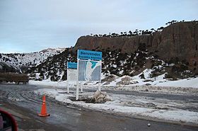
Cardenal Antonio Samoré Pass is one of the main mountain passes through the southern Andes along the border between Argentina and Chile.
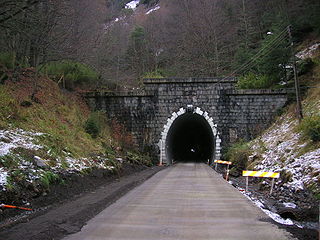
Las Raíces Tunnel is a road tunnel in Chile.
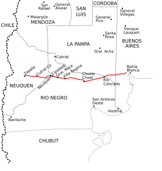
National Route 22 is a highway located in Argentina, that connects the provinces of Buenos Aires, La Pampa, Río Negro and Neuquén in 685 km (426 mi). The route starts at the connection with National Route 3 (Argentina), 32 km (20 mi) at the west of Bahía Blanca and until 2004 the highway end was in Paso de Pino Hachado, on the border with Chile, but currently ends on the connection with National Route 40 (Argentina) in Zapala. The track between Las Lajas and Paso de Pino Hachado is now part of the National Route 242. The Highway has two lanes, mostly; only the Cipolletti - Plottier track has 4 lanes.
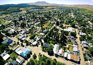
Las Lajas is a town in Neuquén Province, Argentina, and the capital of Picunches Department. The town, at an altitude of 900 metres (3,000 ft) above mean sea level, is located on the right shore of Agrio River at the Andean foothills. National Routes 22 and 40 intersect in this area of the central Neuquén Province. The Cuchillo Curá range, considered the most important underground ecosystem in Argentina, extends approximately 10 kilometres (6.2 mi) from Las Lajas.
Hiking in Chile is characterized by a wide range of environments and climates for hikers, which largely results from Chile's unusual, ribbon-like shape, which is 4,300 kilometres long and on average 175 kilometres wide. These range from the world's driest desert, the Atacama, in the north, through a Mediterranean climate in the center, to the glaciers, fjords and lakes of Patagonia in the south.

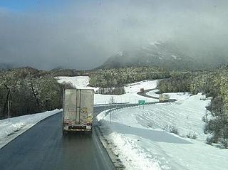
Route 181-CH is a branch line road going eastward from Chile Highway 5 at Victoria to Pino Hachado Pass at the border to Argentina. Through its length the road passes along or close to the cities and towns of Victoria and Lonquimay. All of the route runs inside La Araucanía Region and between Curacautín and Lonquimay the road runs through Las Raíces Tunnel, Chile's longest tunnel.

The Salta–Antofagasta railway, also named Huaytiquina, is a non-electrified single track railway line that links Argentina and Chile passing through the Andes. It is a 1,000 mmmetre gauge railway with a total length of 941 km, connecting the city of Salta (Argentina) to the one of Antofagasta (Chile), on the Pacific Ocean, passing through the Puna de Atacama and Atacama Desert.
Cura-Mallín Group is a heterogeneous group of volcano-sedimentary formations of Oligocene-Miocene age, Colhuehuapian to Laventan in the SALMA classification, in south-central Chile and nearby parts of Argentina. The sediments belonging to the group were deposited in a lacustrine environment and alongside rivers in an intra-arc basin. Southeast of Laguna del Laja Cura-Mallín Group has a thickness of more than 1,800 metres (5,900 ft). The sediments making up the group deposited in an interval between 22 and 8 million years ago.

National Route 242 is a paved highway, which is located in the Picunches Department, in the Argentine province of Neuquén. Along its 60 km (37 mi) route, it joins National Route 40 in the vicinity of the town of Las Lajas with the Pino Hachado Pass, at 1,864 m (6,115 ft) above sea level, on the border with Chile. Until 2004, this section belonged to National Route 22. The route continues in Chile as Route CH-181.