
The Andes, Andes Mountains or Andean Mountain Range are the longest continental mountain range in the world, forming a continuous highland along the western edge of South America. The range is 8,900 km (5,530 mi) long, 200 to 700 km wide, and has an average height of about 4,000 m (13,123 ft). The Andes extend from north to south through seven South American countries: Venezuela, Colombia, Ecuador, Peru, Bolivia, Chile and Argentina.
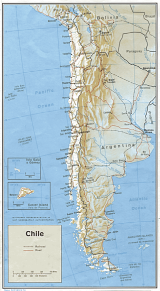
Transport in Chile is mostly by road. The far south of the country is not directly connected to central Chile by road without travelling through Argentina, and water transport also plays a part there. The railways were historically important in Chile, but now play a relatively small part in the country's transport system. Because of the country's geography and long distances between major cities, aviation is also important.
The project of the Pan-American highway began approximately in or before 1923. The main idea was to create a network of wide roads that would connect major points of interest in North and South America with a single highway.

A mountain pass is a navigable route through a mountain range or over a ridge. Since mountain ranges can present formidable barriers to travel, passes have played a key role in trade, war, and both human and animal migration throughout history. At lower elevations it may be called a hill pass. A mountain pass is typically formed between two volcanic peaks or created by erosion from water or wind.
Christ the Redeemer, a reference to Jesus Christ as the Redeemer of humanity, may refer to:

The Trans-Andean railways provide rail transport over the Andes. Several are either planned, built, defunct, or waiting to be restored. They are listed here in order from north to south.

Dagoberto Godoy Fuentealba was a Chilean military pilot and the first person to fly over the Andes.

The Transandine Railway was a 1,000 mmmetre gauge combined rack and adhesion railway which operated from Mendoza in Argentina, across the Andes mountain range via the Uspallata Pass, to Santa Rosa de Los Andes in Chile, a distance of 248 km.

Christ the Redeemer of the Andes is a monument high in the Principal Cordillera of the Andes at 3,832 metres (12,572 ft) above mean sea level on the border between Argentina and Chile. It was unveiled on 13 March 1904 as a celebration of the peaceful resolution of the border dispute between the two countries.

The Paso Internacional Los Libertadores, also called Cristo Redentor, is a mountain pass in the Andes between Argentina and Chile. It is the main transport route out of the Chilean capital city Santiago into Mendoza Province in Argentina and so carries quite heavy traffic.

Portillo is a ski resort in South America, located in the Andes mountains of Chile. In the Valparaíso Region, it is 61 km (38 mi) from Los Andes, the nearest city, and 160 km (100 mi) by vehicle from Santiago. Its hotel sits at an elevation of 2,880 m (9,450 ft) above sea level, and the highest lift reaches 3,310 m (10,860 ft). The lowest lift loads at 2,548 m (8,360 ft), yielding a vertical drop of 762 m (2,500 ft). Ski Portillo has 35 named runs and 14 lifts. It is owned and operated by the Purcell family who have a chain of hotels in Chile, most noticeably the Tierra Hotels including Tierra Atacama in San Pedro de Atacama.
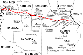
National Route 7 is a road in Argentina. It crosses the country from east to west, from the capital to the border with Chile, thus linking the Atlantic coast with the Andes, crossing the provinces of Buenos Aires, Santa Fe, Córdoba, San Luis and Mendoza. It has a total length of 1,224 km (761 mi), of which 367 km (228 mi) (30%) are freeways.
The Paso de Los Patos(Passage of the Ducks) is an Andean mountain pass between Argentina and Chile, used by the main column of the Army of the Andes to cross the Andes in early 1817, in order to liberate Chile from Spain. It is located to the interior of the town of Putaendo, to the north of the city of San Felipe, Valparaíso Region, Chile, and framed by the imposing Valle de Los Patos Sur, SW of the Province of San Juan, Argentina. Other names are used for the same pass: the passages of Llaretas, Ortiz, the Honda and the Valle Hermoso.

National Route A006 is a gravel road of 8.5 km (5.3 mi) connecting the town of Las Cuevas on the northwest of the province of Mendoza with the Christ the Redeemer monument in the border between Argentina and Chile. This road is only open in the summer season. It is always important to inquire in the cities of Mendoza or Uspallata on the road conditions as it could be impassable at times. In it winding length it changes altitude from 3,151 m (10,338 ft) to 3,832 m (12,572 ft).

The Paso de Jama is a mountain pass through the Andes between Chile and Argentina, at an elevation of 4,200 m (13,800 ft) at the border. It is the northernmost road border crossing between the two countries. The pass is reached via Chile Route 27 and via National Route 52 (Argentina). The Chile Route 27 reaches an altitude according to OpenStreetMap of 4,831 metres (15,850 ft) at 23°04′21″S67°30′17″W in a road distance of 57.6 kilometres (35.8 mi) west of the border, making it one of the highest highways in South America.

Chile Route 60 is a main road in the Valparaíso Region of Chile that extends from Valparaíso to Paso Los Libertadores. It continues into Argentina as National Route 7, toward Mendoza.

The Agua Negra Pass is a pass over the Andes mountains which connects Argentina and Chile. The highest point of this pass is at 4,780 m (15,680 ft) AMSL.

The Pichachén Pass is a pass over the Andes mountains that connects Argentina and Chile. The border crossing between Argentina and Chile is at 2,060 m (6,760 ft) AMSL.
The road network of the MERCOSUR, is a network of roads and highways in South America, that constitute a transnational system and links Mercosur main cities and access points.
