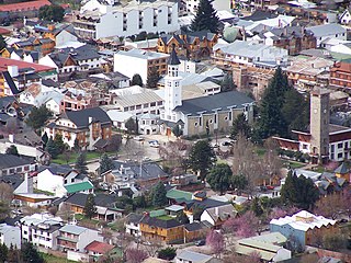
San Martín de los Andes is a city in the south-west of the province of Neuquén, Argentina, serving as the administration centre of the Lácar Department. Lying at the foot of the Andes, on the Lácar lake, it is considered one of the main tourism destinations in the province. The National Route 40 runs to the city, connecting it with important touristic points in the south of the province, such as Lanín and Nahuel Huapí national parks.

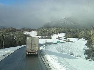
The Uspallata Pass, Bermejo Pass or Cumbre Pass, is an Andean pass which provides a route between the wine-growing region around the Argentine city of Mendoza, the Chilean city Los Andes and Santiago, the Chilean capital situated in the central Chilean valley.

The Transandine Railway was a 1,000 mmmetre gauge combined rack and adhesion railway which operated from Mendoza in Argentina, across the Andes mountain range via the Uspallata Pass, to Santa Rosa de Los Andes in Chile, a distance of 248 km.

The Paso Internacional Los Libertadores, also called Cristo Redentor, is a mountain pass in the Andes between Argentina and Chile. It is the main transport route out of the Chilean capital city Santiago into Mendoza Province in Argentina and so carries quite heavy traffic.
Cardenal Antonio Samoré Pass is one of the main mountain passes through the southern Andes along the border between Argentina and Chile.
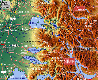
Hua Hum Pass is an international mountain pass in the Andes between Chile and Argentina. The pass takes its name from the Hua Hum River that flows from Argentina into Chile at the site of the border crossing. Even though the pass does not go through the continental divide, it crosses the highest peaks of the cordillera.

Pino Hachado Pass is a mountain pass through the Andes, joining Chile and Argentina. It is one of the principal passes of the southern Andes, connecting Argentina's route RN-242 and Chile's Route 181-CH.

Nevado San Francisco, or Cerro San Francisco, is a stratovolcano on the border between Argentina and Chile, located just southeast of San Francisco Pass. It is considered extinct and is one of the several 6,000 m (19,700 ft) peaks in the area, of which the chief is the Ojos del Salado. It is on the border of 2 provinces: Argentinean province of Catamarca; Chilean province of Copiapo.
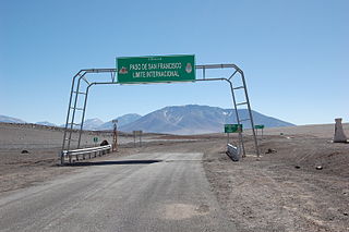
The San Francisco Pass is a pass over the Andes mountains which connects Argentina and Chile. The highest point of this pass is at 4,726 m (15,505 ft) AMSL.

The Paso de Jama is a mountain pass through the Andes between Chile and Argentina, at an elevation of 4,200 m (13,800 ft) at the border. It is the northernmost road border crossing between the two countries. The pass is reached via Chile Route 27 and via National Route 52 (Argentina). The Chile Route 27 reaches an altitude according to OpenStreetMap of 4,831 metres (15,850 ft) at 23°04′21″S67°30′17″W in a road distance of 57.6 kilometres (35.8 mi) west of the border, making it one of the highest highways in South America.
Nevado Olivares also known as Cerro de Olivares, is a mountain in the Andes Mountains at the Chile-Argentina border. It lies just south of the Agua Negra Pass, one of the highest road passes in the Andes. It has a height of 6,216 metres (20,394 ft).

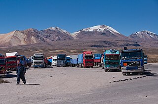
Chungara–Tambo Quemado is a mountain pass through the Cordillera Occidental of the Andes along the border between Chile and Bolivia. Chungara–Tambo Quemado is one of the principal Chile-Bolivia passes in the central Andes as it connects La Paz with its nearest seaport Arica.

Huishue Lake, Mapudungun for bad place to live, is located in the Andes of the Lago Ranco commune in southern Chile. More precisely the lake is located 10 km south of Maihue Lake, 15 km northeast of Puyehue Volcano and 10 km west of the Chile-Argentina border.

Lanín is an ice-clad, cone-shaped stratovolcano on the border of Argentina and Chile. It forms part of two national parks: Lanín in Argentina and Villarrica in Chile. As a part of the flag and anthem of the Argentine province of Neuquén, it serves as a symbol for the region. Although the date of its last eruption is not known, it is estimated to have occurred within the last 10,000 years. Following the 1906 Valparaíso earthquake a local newspaper reported the volcano to have erupted, but a work published in 1917 by Karl Sapper disputed this.

Sico Pass is a mountain pass on the border between Argentina and Chile. The pass is located on the main divide of the Andes. Administratively, it separates the province of Salta in Argentina and the region of Antofagasta in Chile.
Umurata is a mountain in the Andes, about 5,717 m (18,757 ft) high, situated in the Cordillera Occidental on the border of Bolivia and Chile. It is located in the Arica and Parinacota Region of Chile and in the Oruro Department of Bolivia, in the Sajama Province, Turku Municipality, Chachakumani Canton. Umurata lies south of the Uqi Uqini volcano, north of the Acotango and north-east of the Wallatiri volcano. Argon-argon dating has yielded ages of 970,000±120,000 for Umurata rocks. Umurata is situated south of National Route 4 near the Chungara-Tambo Quemado pass.

The Agua Negra Pass is a pass over the Andes mountains which connects Argentina and Chile. The highest point of this pass is at 4,780 m (15,680 ft) AMSL.

The Pircas Negras Pass is a pass over the Andes mountains which connects Argentina and Chile. The border crossing between Argentina and Chile is at 4,164 m (13,661 ft) AMSL.

The Pichachén Pass is a pass over the Andes mountains that connects Argentina and Chile. The border crossing between Argentina and Chile is at 2,060 m (6,760 ft) AMSL.

Paso Pehuenche is an Andean mountain pass and international border crossing between Chile and Argentina. It connects Talca and San Clemente in Chile with Malargüe in Argentina.
