Salta is a province of Argentina, located in the northwest of the country. Neighboring provinces are from the east clockwise Formosa, Chaco, Santiago del Estero, Tucumán and Catamarca. It also surrounds Jujuy. To the north it borders Bolivia and Paraguay and to the west lies Chile.

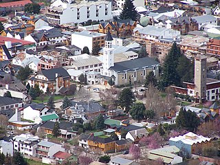
San Carlos de Bariloche, usually known as Bariloche, is a city in the province of Río Negro, Argentina, situated in the foothills of the Andes on the southern shores of Nahuel Huapi Lake. It is located within the Nahuel Huapi National Park. After development of extensive public works and Alpine-styled architecture, the city emerged in the 1930s and 1940s as a major tourism centre with skiing, trekking and mountaineering facilities. In addition, it has numerous restaurants, cafés, and chocolate shops. The city had a permanent population of 108,205 according to the 2010 census. According to the latest statistics from 2015, the population is around 122,700, and a projection for 2020 estimates 135,704.

San Pedro de Atacama is a Chilean town and commune in El Loa Province, Antofagasta Region. It is located east of Antofagasta, some 106 km (60 mi) southeast of Calama and the Chuquicamata copper mine, overlooking the Licancabur volcano. It features a significant archeological museum, the R. P. Gustavo Le Paige Archaeological Museum, with a large collection of relics and artifacts from the region. Native ruins nearby attract increasing numbers of tourists interested in learning about pre-Columbian cultures.
San Martín de los Andes is a city in the south-west of the province of Neuquén, Argentina, serving as the administration centre of the Lácar Department. Lying at the foot of the Andes, on the Lácar lake, it is considered one of the main tourism destinations in the province. The National Route 40 runs to the city, connecting it with important touristic points in the south of the province, such as Lanín and Nahuel Huapí national parks.

The Transandine Railway was a 1,000 mmmetre gauge combined rack and adhesion railway which operated from Mendoza in Argentina, across the Andes mountain range via the Uspallata Pass, to Santa Rosa de Los Andes in Chile, a distance of 248 km.

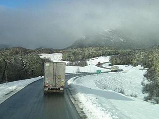
National Route 40, also known as RN40 or "Ruta 40", is a route in western Argentina, stretching from Cabo Vírgenes near Río Gallegos in Santa Cruz Province in the south to La Quiaca in Jujuy Province in the north with approximately 5194 km length. The route parallels the Andes mountains. The southern part of the route, by now largely paved, has become a well-known adventure tourism journey, and there are plans to pave the whole road.

The Paso Internacional Los Libertadores, also called Cristo Redentor, is a mountain pass in the Andes between Argentina and Chile. It is the main transport route out of the Chilean capital city Santiago into Mendoza Province in Argentina and so carries quite heavy traffic.

Portillo is a ski resort in South America, located in the Andes mountains of Chile. In the Valparaíso Region, it is 61 km (38 mi) from Los Andes, the nearest city, and 160 km (100 mi) by vehicle from Santiago. Its hotel sits at an elevation of 2,880 m (9,450 ft) above sea level, and the highest lift reaches 3,310 m (10,860 ft). The lowest lift loads at 2,548 m (8,360 ft), yielding a vertical drop of 762 m (2,500 ft). Ski Portillo has 35 named runs and 14 lifts. It is owned and operated by the Purcell family who have a chain of hotels in Chile, most noticeably the Tierra Hotels including Tierra Atacama in San Pedro de Atacama.

Salar de Atacama, located 55 km (34 mi) south of San Pedro de Atacama, is the largest salt flat in Chile. It is surrounded by mountains and lacks drainage outlets. To the east, it is enclosed by the main chain of the Andes, while to the west lies a secondary mountain range called Cordillera de Domeyko. The landscape is dominated by imposing volcanoes such as Licancabur, Acamarachi, Aguas Calientes, and Láscar, the latter being one of Chile's most active volcanoes. These volcanoes are situated along the eastern side of the Salar de Atacama, forming a north–south trending line that separates it from smaller endorheic basins.
Cardenal Antonio Samoré Pass is one of the main mountain passes through the southern Andes along the border between Argentina and Chile.

The Atacama Desert is a desert plateau located on the Pacific coast of South America, in the north of Chile. Stretching over a 1,600-kilometre-long (1,000-mile) strip of land west of the Andes Mountains, it covers an area of 105,000 km2 (41,000 sq mi), which increases to 128,000 km2 (49,000 sq mi) if the barren lower slopes of the Andes are included.
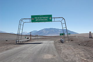
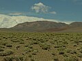
The San Francisco Pass is a pass over the Andes mountains which connects Argentina and Chile. The highest point of this pass is at 4,726 m (15,505 ft) AMSL.

The Paso de Jama is a mountain pass through the Andes between Chile and Argentina, at an elevation of 4,200 m (13,800 ft) at the border. It is the northernmost road border crossing between the two countries. The pass is reached via Chile Route 27 and via National Route 52 (Argentina). The Chile Route 27 reaches an altitude according to OpenStreetMap of 4,831 metres (15,850 ft) at 23°04′21″S67°30′17″W in a road distance of 57.6 kilometres (35.8 mi) west of the border, making it one of the highest highways in South America.
Hiking in Chile is characterized by a wide range of environments and climates for hikers, which largely results from Chile's unusual, ribbon-like shape, which is 4,300 kilometres long and on average 175 kilometres wide. These range from the world's driest desert, the Atacama, in the north, through a Mediterranean climate in the center, to the glaciers, fjords and lakes of Patagonia in the south.

Portezuelo del Cajón, also known as Hito Cajón, is a mountain pass on the border between Chile and Bolivia, located on the lower southeast flank of Juriques volcano, close to the Licancabur volcano. While Bolivian customs are completed at the top of the pass, Chilean customs are completed in the town of San Pedro de Atacama, 45 kilometres (28 mi) away. The road over the pass begins at the junction with Chile Route 27, close to Cerro Toco.

Los Andes is a department located in Salta Province, Argentina. It is the second largest by area in the province, after Rivadavia Department, and its capital is the town of San Antonio de los Cobres.

The Salta–Antofagasta railway, also named Huaytiquina, is a non-electrified single track railway line that links Argentina and Chile passing through the Andes. It is a 1,000 mmmetre gauge railway with a total length of 941 km, connecting the city of Salta (Argentina) to the one of Antofagasta (Chile), on the Pacific Ocean, passing through the Puna de Atacama and Atacama Desert.

Chile Route 23 is a main road in the northern portion of Chile. It runs for 192.48 km (119.60 mi) from Calama to Sico Pass.

The Pircas Negras Pass is a pass over the Andes mountains which connects Argentina and Chile. The border crossing between Argentina and Chile is at 4,164 m (13,661 ft) AMSL.