The Arctic Archipelago, also known as the Canadian Arctic Archipelago, is an archipelago lying to the north of the Canadian continental mainland, excluding Greenland and Iceland.

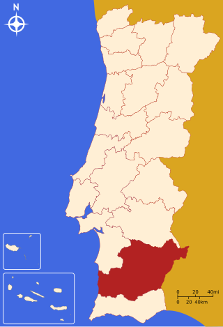
The Beja District is located in southern Portugal. The district capital is the city of Beja. It is the largest district of the country by area, comprising around 11% of Portuguese territory.
Quartermain Glacier is a well-defined, highly crevassed glacier on the north side of Fricker Glacier, from which it is separated in its upper reaches by Mount Kennett. It flows from the plateau into Mill Inlet on the east coast of Graham Land, and was named by the United Kingdom Antarctic Place-Names Committee (UK-APC) for Leslie B. Quartermain, New Zealand historian of the Antarctic and author of South to the Pole. The early history of the Ross Sea Sector.
Quest Channel is a channel leading southwestward from Adelaide Anchorage between Hibbert Rock and Henkes Islands, off the south end of Adelaide Island. It was named by the United Kingdom Antarctic Place-Names Committee (UK-APC) after the survey motorboat which charted this area in 1963.

Ahlmann Glacier is the southernmost of two glaciers on the east side of Hemimont Plateau flowing east into Seligman Inlet on Bowman Coast, Graham Land in Antarctica.
Usmanabad or Osmanabad is a neighborhood in Karachi, Pakistan, that is within Malir District.
Cerro Amaculla is a mountain in the Andes of Chile. It has a height of 4,380 metres (14,370 ft).

The Tuke River is a river of the West Coast Region of New Zealand's South Island. It flows northwest from the Southern Alps, combining with the Dickson River to form the Mikonui River 15 kilometres southeast of Ross.
Mar de Espanha is a municipality in the state of Minas Gerais in the Southeast region of Brazil.
Puerta de San José is a village and municipality in Catamarca Province in northwestern Argentina.
On the continent of Antarctica, the Aramis Range is the third range south in the Prince Charles Mountains, situated 11 miles southeast of the Porthos Range and extending for about 30 miles in a southwest–northeast direction. It was first visited in January 1957 by Australian National Antarctic Research Expeditions (ANARE) southern party led by W.G. Bewsher, who named it for a character in Alexandre Dumas' novel The Three Musketeers, the most popular book read on the southern journey.
Barela Rock is a rock outcrop in the southern part of Przybyszewski Island in the Marshall Archipelago. It was mapped by the United States Geological Survey from surveys and from U.S. Navy air photos, 1959–65, and named by the Advisory Committee on Antarctic Names for Ruben E. Barela, aviation structural mechanic, U.S. Navy, of the McMurdo Station party, 1967.
Grossenbacher Nunatak is a nunatak at the southwest end of the Lyon Nunataks, Palmer Land, Antarctica, 2 nautical miles (4 km) southwest of Holtet Nunatak. It was named by the Advisory Committee on Antarctic Names after Ernest P. Grossenbacher, an upper atmospheric physicist at Siple Station, 1970–71.
Steinemann Island is an island off the northeast coast of Adelaide Island, about 10 nautical miles (18 km) southwest of Mount Velain. Mapped from air photos taken by Ronne Antarctic Research Expedition (RARE) (1947–48) and Falkland Islands and Dependencies Aerial Survey Expedition (FIDASE) (1956–57). Named by United Kingdom Antarctic Place-Names Committee (UK-APC) for Samuel Steinemann, Swiss physicist who has made laboratory investigations on the flow of single and polycrystalline ice.
Solus Island is an island off the Antarctic Peninsula, lying 3 nautical miles (6 km) south of the Guébriant Islands, tio the south-southeast of Cape Alexandra at the south end of Adelaide Island. The name appears as Islote Solitario, meaning 'solitary islet', on an Argentine government chart of 1957. The name indicates its isolated position. The name 'Solus Island' was adopted on British charts
Regent Reef is an area of submerged and drying rocks forming the northeast limit of the Dion Islands, off the south end of Adelaide Island. Charted by the Royal Navy Hydrographic Survey Unit in 1963. The name given by the United Kingdom Antarctic Place-Names Committee (UK-APC) extends those in the neighboring islands associated with an emperor's court.
Hijrat Colony is one of the neighbourhoods of Lyari Town in Karachi, Sindh, Pakistan.
Haji Camp is one of the neighbourhoods of Lyari Town in Karachi, Sindh, Pakistan. The Hajji pilgrims lived here before taking the ships to Saudi Arabia to perform Hajj.


