
The Andes, Andes Mountains or Andean Mountain Range are the longest continental mountain range in the world, forming a continuous highland along the western edge of South America. The range is 8,900 km (5,530 mi) long, 200 to 700 km wide, and has an average height of about 4,000 m (13,123 ft). The Andes extend from north to south through seven South American countries: Venezuela, Colombia, Ecuador, Peru, Bolivia, Chile and Argentina.

Uruguayan Air Force Flight 571 was the chartered flight of a Fairchild FH-227D from Montevideo, Uruguay, to Santiago, Chile, that crashed in the Andes mountains on October 13, 1972. The accident and subsequent survival became known as the Andes flight disaster and the Miracle of the Andes.

The University of the Andes, also commonly self-styled as Uniandes, is a private research university located in the city centre of Bogotá, Colombia. Founded in 1948 by a group of Colombian intellectuals led by Mario Laserna Pinzón, it was the first Colombian university established as nonsectarian.
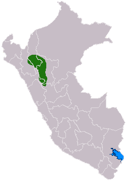
The Chachapoyas, also called the "Warriors of the Clouds", was a culture of the Andes living in the cloud forests of the southern part of the Department of Amazonas of present-day Peru. The Inca Empire conquered their civilization shortly before the Spanish conquest in the 16th century. At the time of the arrival of the conquistadors, the Chachapoyas were one of the many nations ruled by the Incas, although their incorporation had been difficult due to their constant resistance to Inca troops.

Tupungato, one of the highest mountains in the Americas, is a massive Andean lava dome dating to Pleistocene times. It lies on the Argentina–Chile border, between the Chilean Metropolitan Region and the Argentine province of Mendoza, about 100 km (62 mi) south of Aconcagua, the highest peak of both the Southern and Western hemispheres. Immediately to its southwest is the active Tupungatito volcano, which last erupted in 1987.

Mark Andes is an American musician, known for his work as a bassist with Canned Heat, Spirit, Jo Jo Gunne, Firefall, Heart, and Mirabal.

The Cordillera Oriental is the widest of the three branches of the Colombian Andes. The range extends from south to north dividing from the Colombian Massif in Huila Department to Norte de Santander Department where it splits into the Serranía del Perijá and the Cordillera de Mérida in Venezuelan Andes. The highest peak is Ritacuba Blanco at 5,410 m (17,750 ft) in the Sierra Nevada del Cocuy.

Teresa of Jesus of Los Andes, born as Juana Enriqueta Josephina de Los Sagrados Corazones Fernández Solar, was a Chilean nun of the Discalced Carmelites. Fernández Solar was a pious child but had an often unpredictable temperament for she could be prone to anger and being vain but could also demonstrate her charitable and loving nature; she seemed transformed when she decided to become a nun and her character seemed to change for her sole ambition was to dedicate herself to the service of God. But her time in the convent was cut short due to her contracting an aggressive disease that killed her - she knew she would die but was consoled knowing she would be able to make her profession before she died.

The Andean region, located in central Colombia, is the most populated natural region of Colombia. With many mountains, the Andes contain most of the country's urban centers. They were also the location of the most significant pre-Columbian indigenous settlements. Beyond the Colombian Massif in the south-western departments of Cauca and Nariño, the Colombian Andes divide into three branches known as "cordilleras" : the West Andes run adjacent to the Pacific coast and is home to the city of Cali. The Central Andes run up the center of the country between the Cauca and Magdalena river valleys and includes the cities of Medellín, Manizales and Pereira. The East Andes extend northeast towards the Guajira Peninsula, and includes the cities of Bogotá, Bucaramanga and Cúcuta.
Trasandino de Los Andes is a Chilean Football club, their home town is Los Andes in the V Región of Valparaíso in Chile. They currently play in the Segunda División.
The División Mayor del Básquetbol de Chile, DIMAYOR, was one of the national professional basketball leagues in Chile, along with the Liga Nacional Movistar. The league was created in 1979 and was discontinued in 2013.

Club Atlético Los Andes is an Argentine sports club based in the Lomas de Zamora district of Greater Buenos Aires. The football team currently plays in the Primera B, the third division of the Argentine football league system.

Chearoco, Chiaraco or Chiaroco is a mountain in the Cordillera Real in the Andes of Bolivia. It has a height of about 6,127 m (20,102 ft). It is situated in the La Paz Department, Larecaja Province, Guanay Municipality, southeast of the peak of Aman Pata. Chearoco lies between Qalsata in the northwest and Chachakumani in the southeast.

The Andean orogeny is an ongoing process of orogeny that began in the Early Jurassic and is responsible for the rise of the Andes mountains. The orogeny is driven by a reactivation of a long-lived subduction system along the western margin of South America. On a continental scale the Cretaceous and Oligocene were periods of re-arrangements in the orogeny. The details of the orogeny vary depending on the segment and the geological period considered.
Jachacunocollo, also known as Jacha Cuno Collo, Tres Marias, Don Luis or Jacha Collo is a mountain in the Andes in Bolivia. It is the highest elevation in the Quimsa Cruz Range reaching an elevation of about 5,800 metres (19,029 ft). Jachacunocollo is situated in the La Paz Department, Inquisivi Province, Quime Municipality, north-west of Wayna Khunu Qullu, the second highest mountain in this mountain range.

Machu Such'i Qhuchi or Machu Such'i Q'uchi is a mountain in the Apolobamba mountain range in the Bolivian Andes, about 5,679 metres (18,632 ft) high. It is situated near the Peruvian border in the La Paz Department, Franz Tamayo Province, Pelechuco Municipality, east of Such'i Lake.
Wila Lluxi is a mountain in the Andes, about 5,596 m (18,360 ft) high. It lies in the Cordillera Real of Bolivia in the La Paz Department, Los Andes Province, Batallas Municipality, Kirani Canton. It is situated on the western side of the Janq'u Quta valley next to the mountains Warawarani and Phaq'u Kiwuta. Other prominent mountains nearby are Janq'u Laya and Janq'u Uyu in the north, and Wila Lluxita and Mullu Apachita in the northeast, all of them higher than 5,000 m.
Phaq'u Kiwuta is a mountain in the Andes, about 5,589 m (18,337 ft) high. It is located in the Cordillera Real of Bolivia in the La Paz Department, Los Andes Province, Batallas Municipality, Kirani Canton. It is situated south-west of the mountain Wila Lluxi, south-east of Warawarani and north of a lake named Quta Thiya in some maps. Other prominent mountains nearby are Jisk'a Pata and Janq'u Uyu in the north, and Wila Lluxita and Mullu Apachita in the north-east, all of them higher than 5,000 m.
Calzada is a mountain in the Andes, about 5,874 m (19,272 ft) high, located in the Cordillera Real of Bolivia. It lies in the La Paz Department, Larecaja Province, on the border of the Sorata Municipality and the Guanay Municipality. It is situated south-east of Ancohuma, between the mountain Q'asiri in the north-west and Chearoco in the south-east, and east of San Francisco Lake.