Sites in Pennsylvania

Although there have been over a dozen diabase ringing rock boulder fields identified in the Pennsylvania and New Jersey area, [5] [ full citation needed ] the majority are either on private property or have been obliterated by urban development. There are three sites north of Philadelphia which are readily accessible to the public: [6] Ringing Rocks County Park, Stony Garden, and Ringing Hill Park.
Ringing Rocks County Park

Ringing Rocks County Park, also known as Ringing Rocks Park, is a Bucks County park near Upper Black Eddy in Bridgeton Township. [7] Originally, the land was acquired by the Penn family from the Lenape (Delaware Nation) through the infamous 1737 Walking Purchase. It is not clear who made the original land warrant for the area now covered by the Ringing Rocks County Park. On the 1850 property map of Bucks County, the owner appears to be Tunis Lippincott; however, there is no warrantee listing under that name. The earliest published description of the Bridgetown boulder field is found in Davis 1876. [8] The seven-acre boulder field was purchased in 1895 by Abel B. Haring, president of the Union National Bank in Frenchtown, New Jersey. Apparently, Haring wished to protect the ringing rocks from development, and even refused an offer from a manufacturer of Belgian blocks for the right to quarry the stones. [9] [10] On August 22, 1918, the land which contains the Bridgeton Boulder Field was donated by Haring to the Bucks County Historical Society. The grant included 7 acres 8.08 perches of land. A right-of-way was granted by John O. McEntee for access to the park. [3] Later, the land was transferred to Bucks County and operated as a county park. Additional land acquisitions have increased the size of the park to 129 acres.
Ringing Hill Park

Ringing Hill Park is located three miles northeast of Pottstown, Pennsylvania in Montgomery County. The boulder field was first identified in 1742 when a road was cut between Pottstown and New Gosenhoppen (Pennsburg). In 1894, the Ringing Rocks Electric Railway Company was incorporated to purchase the remote Ringing Hill for an amusement park and provide trolley service (1894 to 1932). At the time it was created, the park was approximately 2 miles (3.2 km) out of town. The park was purchased in 1932 by Walter J. Wolf and operated as an amusement park and skating rink. On September 1, 1957, the park was sold to the Ringing Hill Fire Company. [11]
Stony Garden
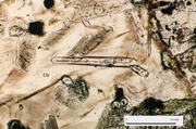
The Stony Garden, largest of the three public ringing rock boulder fields, is located on the northwest slope of Haycock Mountain in Bucks County, Pennsylvania, near Bucksville. The garden is actually a series of disconnected boulder fields which extend for nearly half a mile, and were formed where the olivine diabase unit crops out along the base of the mountain. The site is undeveloped, and is accessible by a hiking trail which leads from a PA Game Lands parking area on Stony Garden Road. It was purchased by the Commonwealth of Pennsylvania around 1920 as part of PA Game Lands Tract #157, which covers Haycock Mountain. [12]
Buckwampun Historical Society meetings
The ringing rock boulder fields were popular places for meetings of the local Buckwampun Historical Society. Two annual meetings were held at the Bridgeton site (in 1893 and 1898), and one at Stony Garden (in 1890). [10] The Bucks County Historical Society also had a meeting at the Bridgeton site in 1919, the year after they acquired the property. [3]
At the third annual BHS meeting in June 1890 a local physician, John J. Ott of Pleasant Valley, gave a musical performance using boulders taken from the Stony Garden boulder field. The suggestion for the construction of the lithophone was made by the historian William J. Buck. The rocks weighed approximately 200 lb (91 kg) apiece, and apparently Ott was able to change their sound by slightly chipping the boulders. He played several selections using a steel hammer and accompanied by a brass band. "The clear, bell-like tones of the rocks could be heard above the notes of the horns." [3] [9] [10] The tunes included "Home Sweet Home" and a composition of his own entitled "Sounds from the Ringing Rocks" – possibly a takeoff from the 1873 piano music score of the same name. [13]
Formation
These boulder fields in southeastern Pennsylvania and central New Jersey formed from a group of diabase sills in Newark Basin. The sills were formed when stretching of the Earth's crust allowed mafic magma to travel up from the upper mantle inject into the sedimentary basin 200 million years ago (early Jurassic Period). Phenocrysts of two minerals that had crystallized in the upper mantle, olivine and pyroxene, quickly settled out of the magma and collected along the base of the sills. When fully solidified, this crystal-rich layer formed a separate rock unit 10–15 ft (3.0–4.6 m) thick. [14] By the Pleistocene Epoch, the sills had been exposed to the surface by crustal uplift and erosion. During the Pleistocene, outcrops of the olivine diabase were not buried by the glacial sheets; however, they were subjected to severe freezing, or periglacial, conditions. The periglacial environment caused the outcrops to be broken into extensive boulder fields.
Geology
The basal olivine unit is similar to the one found in the Palisades Sill in New Jersey and New York. The olivine diabase unit is significantly harder, denser, and more resistant to weathering than the upper portions of the diabase sill.
Most observers did not make the distinction between the upper "normal" diabase which is found over wide areas, and the thin olivine diabase unit found at the base of the sills which actually produces the ringing rock boulder fields. A main factor in the confusion is the outward appearance of the rocks. Both the normal and olivine diabase rocks are dark grey to black in color. Microscopic examination is often required to identify the differences.
Although the Newark series diabase sills crop out in a belt throughout the length of the Appalachian Mountains, only a narrow band of outcrops in southeastern Pennsylvania and New Jersey develop ringing rock boulder fields. The probable reason is that these areas were at the southern edge of the Pleistocene glaciers, and would have been subject to extreme periglacial conditions. Periglacial boulder fields are a common feature in Pennsylvania and New Jersey.
All of the observed ringing rock boulder fields in southeastern Pennsylvania and New Jersey are a form of felsenmeer (felsenmeer is a German term meaning "sea of rock"). These barren block fields occur in periglacial environments where outcrops of resistant rock are exposed with a slope of less than 25°. Frost wedging breaks up the upper portion of the rock formation, and the slight dip of the field allows the fine weathering materials to be flushed away before soil can develop. Often, the boulders are lifted and rotated by the accumulation of snow and ice, leaving a considerable amount of vacant space between them. The felsenmeer boulder fields form in-situ due to the low-slope angles. In situations where the slope angles are steeper than 25°, gravity tends to move the boulders downhill to form scree or talus slopes. In fields where the angle is too flat, the spaces between the boulders fills with soil and the boulders break down due to weathering.
Because the olivine diabase unit is relatively thin there was an additional requirement for the formation of the ringing rock boulder fields: the olivine diabase unit had to be dipping in the same direction as the slope of the ground surface. This specific dip-slope situation allowed broad expanses of olivine diabase to be exposed and provided enough material to create the fields. In all of the observed boulder fields the structural dip of the unit was approximately 8-10°, and the ground surface slope was <15° in the same direction. Typically this occurred where the olivine diabase unit dipped at right angles into a shallow drainage. Where the olivine diabase does not dip in the same direction as the ground surface there are generally numerous boulders embedded in the soil (boulder colluvium), but no boulder fields.
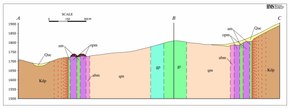
 Typical Cross-section of a Ringing Rock Boulder Field
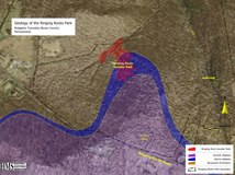 Geology of the Ringing Rocks Park
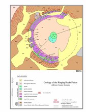
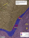 Geology of the Stony Garden


Ringing ability
There has been a great deal of controversy concerning the ringing ability of the boulders; conversely, there has been an almost complete lack of testing to support the conjectures. Conditions such as size and shape of the boulders and the way that the boulders are supported or stacked certainly influence the sounds that the boulders make but do not in themselves impart the ringing ability.
Although the sound is often described as metallic, it is most likely due to a combination of the density of the rock and a high degree of internal stress. The sound can be duplicated on a small scale by tapping the handle of a ceramic coffee cup.
The iron content of the diabase is often identified as the source of the ringing ability. Actual chemical analysis of the Coffman Hill diabase [14] shows that iron content (as ferric oxide) of the rock ranges from 9% and 12%. Although comparatively high for an average igneous rock (3% is typical for granite), it is within the normal range for a basalt. This point suggests that the iron content is not a primary factor in the ringing ability.
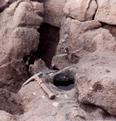
So far, there has been only one published scientific experiment on the source of the ringing ability. In the 1960s, a Rutgers University professor did an informal experiment where specimens of "live" and "dead" ringing rock boulders from the Bucks County park site were sawed into thin slices and then measured for changes in shape. [15] The rock slices were measured with delicate foil strain gauges, which could measure minute changes in size. According to the professor, the dead rocks showed no change after the rocks were sawed; however, the live rocks showed a distinctive expansion or "relaxation" within 24 hours of being cut. This relaxation indicates that the rock was under internal elastic stresses that were released by the mechanical sawing of the rock. The professor went on to make the observation that the live rocks were generally found toward the middle of the boulder fields, where they did not come in contact with soil and the shade of the surrounding trees. He then theorized that the slow weathering rate in the dry "microclimate" of the fields caused the stresses, because the outside skin of the boulders would expand owing to the conversion of pyroxene to montmorillonite (a clay mineral). Boulders along the periphery of the fields weather too quickly and break apart before the stresses can develop.
Although more rigorous testing needs to be done to verify these results, it does suggest strongly that the ringing ability is a direct result of internal stresses. Less likely is the assertion that outside weathering conditions created the stresses. It is very improbable that the expansion of a thin skin around the outside of a large boulder could set up a balance of forces that would create the severe stresses found in the ringing rock boulders. The result of such a situation would be that the outside skin of the boulders would peel or exfoliate, a condition that is virtually non-existent in any of the ringing rocks sites. In addition, the majority of the weathering in the boulders occurs at the exposed top surfaces, not on the bottoms; thus, the stresses would not be balanced. Furthermore, if slow weathering created the stresses, then there would be ringing rock boulder fields in deserts throughout the world, a condition which does not occur.
An important point made in the experiment is the observation that the rock slices expanded when the stress was released. This distinction requires that the rock was under extreme compressive stress, not tension as the slow weathering theory implies.
A more plausible theory is that the elastic stresses remained in the rock when the boulder fields formed, and the slow weathering rate keeps the stresses from dissipating. A possible source of the stresses would likely be the loading stresses from the time when the rock crystallized. The diabase sill formed at roughly 1.2–1.9 miles (2–3 km) beneath the surface. [16] The overlying column of rock creates severe stresses in rocks. The effects of these stresses can be seen in deep mines with a depth of over a mile, where the sudden decompression creates rock bursts. Residual loading stresses would be evenly distributed throughout the boulders. This theory supports the observation that usually less than a third of the boulders in any given field are "live". The stresses are relieved in boulders that have been either mechanically broken or are severely weathered, and therefore no longer ring.
This "relict stress" theory implies that the ringing rock boulders act much like a guitar string. When a guitar string is limp it does not resonate, but a plucked string will provide a range of sounds depending on the level of applied tension. Likewise, a ringing rock boulder will only emit a dull thud if the boulder is de-stressed; however, boulders will resonate at various frequencies depending on the level of residual stress.
The boulders continue to ring when removed from the boulder fields. Myths have been developed by authorities to discourage the theft of boulders from the fields. At the current stage, however, most fields have been picked clean of small portable "ringers", and breaking of large boulders into smaller pieces releases the internal stresses—thus causing them to stop ringing (i.e., breaking a piece off of a large ringing rock will only gain a dead chunk of rock). "Small" ringers found today weigh over a ton and would have to be dragged out of the boulder fields using large equipment.
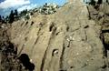
Weathering textures
Often, the weathering textures in boulders take on the form of channels, grooves, "potholes", "mudcracks", and intense pitting. In some cases, the textures are so distinctive that some geologists refer to them in terms of carbonate rock solution features. [16] Inspection of the boulders reveals that the weathering patterns are not due to any internal variations in the rock, but have been superimposed onto the surfaces. The probable source of these textures was chemical weathering along joint surfaces when the rock was still in place and before the boulders were broken out by frost heaving. [17] The soft weathered portion of the outer surfaces flaked off once the boulders were exposed to the air. Small features on the boulder surfaces became exaggerated as the weathered material was removed, so that adjoining fissures became channels, dents became 'potholes', and old surfaces became intensely pitted.
 Weathering channels, Devil's Potato Patch
 Weathering 'potholes', Stony Garden
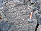 Intense pitting, Stony Garden