Related Research Articles

The Three Gorges Dam is a hydroelectric gravity dam that spans the Yangtze River near Sandouping in Yiling District, Yichang, Hubei province, central China, downstream of the Three Gorges. The world's largest power station in terms of installed capacity (22,500 MW), the Three Gorges Dam generates 95±20 TWh of electricity per year on average, depending on the amount of precipitation in the river basin. After the extensive monsoon rainfalls of 2020, the dam's annual production reached nearly 112 TWh, breaking the previous world record of ~103 TWh set by Itaipu Dam in 2016.

Victoria Falls is a waterfall on the Zambezi River in southern Africa, which provides habitat for several unique species of plants and animals. It is located on the border between Zambia and Zimbabwe and is one of the world's largest waterfalls, with a width of 1,708 m (5,604 ft).

Steens Mountain is in the southeastern part of the U.S. state of Oregon, and is a large fault-block mountain. Located in Harney County, it stretches some 50 miles (80 km) north to south, and rises from the west side the Alvord Desert at elevation of about 4,200 feet (1,300 m) to a summit elevation of 9,738 feet (2,968 m). Steens Mountain is not part of a mountain range but is properly a single mountain, the largest of Oregon's fault-block mountains.
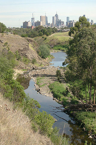
The Merri Creek is a waterway in southern parts of Victoria, Australia which flows through the northern suburbs of Melbourne. It begins near Wallan and flows south for 70 km until joining the Yarra River at Dights Falls. The area where the creek meets the river was traditionally the location for large gatherings of the Wurundjeri people and is suspected to have been the location for one of the earliest land treaties in Australia between Indigenous Australians and European settlers.

The Avon Gorge is a 1.5-mile (2.5-kilometre) long gorge on the River Avon in Bristol, England. The gorge runs south to north through a limestone ridge 1.5 miles (2.4 km) west of Bristol city centre, and about 3 miles (5 km) from the mouth of the river at Avonmouth. The gorge forms the boundary between the unitary authorities of North Somerset and Bristol, with the boundary running along the south bank. As Bristol was an important port, the gorge formed a defensive gateway to the city.

The Wet Tropics of Queensland World Heritage Site consists of approximately 8,940 km2 of Australian wet tropical forests growing along the north-east Queensland portion of the Great Dividing Range. The Wet Tropics of Queensland meets all four of the criteria for natural heritage for selection as a World Heritage Site. World Heritage status was declared in 1988, and on 21 May 2007 the Wet Tropics were added to the Australian National Heritage List.

The New River Gorge National Park and Preserve is a unit of the United States National Park Service (NPS) designed to protect and maintain the New River Gorge in southern West Virginia in the Appalachian Mountains. Established in 1978 as a national river and redesignated in 2020, the park and preserve stretches for 53 miles (85 km) from just downstream of Hinton to Hawks Nest State Park near Ansted.
The Lerderderg Gorge is in Victoria, Australia and largely within the Lerderderg State Park. The Lerderderg River which emerges from the Great Dividing Range has cut a deep gorge as it winds toward the southern plains. It is suggested that the name Lerderderg is perhaps a corruption of the Wurundjeri word "Larderdark," from 'larh' -stone house and 'dark' -peppermint gum.
The Western Cascades or Old Cascades are a sub-province of the Cascade Range in the U.S. state of Oregon, between the Willamette Valley and the High Cascades. The Western Cascades contain many extinct shield volcanoes, cinder cones and lava flows, and the region is highly eroded and heavily forested. Deposits of the same age as the Western Cascades are also found in southwest Washington state.

The Shire of Metcalfe was a local government area about 105 kilometres (65 mi) north-northwest of Melbourne, the state capital of Victoria, Australia, and 45 kilometres (28 mi) south of the regional city of Bendigo. The shire covered an area of 590.52 square kilometres (228.0 sq mi), and existed from 1860 until 1995.

Barfold is a locality situated on the Heathcote-Kyneton Road (C326) in Victoria, Australia. It has a community hall, Barfold Hall, and an Anglican church, Barfold Union Church.

Grevillea repens, the creeping grevillea, is a species of flowering plant in the family Proteaceae and is endemic to Victoria, Australia. It is a prostrate, often mat-forming shrub, that has leaves with 5 to 19 teeth or lobes, and light green or grey, toothbrush-like flowers with reddish striations and a deep red, or dull orange to yellow style.
Point Lillias is a narrow peninsula jutting southwards from the northern coast of Corio Bay, north of the city of Geelong, in Victoria, Australia. It was formed by a southward-trending tongue of lava from the volcanic flows of the Werribee Plains. The seaward end of the peninsula forms a low cliff fringed by shelly beach ridges. Forming the end of the same lava tongue, 500 metres to the south, is a small basalt island known as Bird Rock, connected by a submerged shoal to the peninsula. Point Lillias adjoins the evaporation ponds of the Cheetham saltworks at Avalon. It is listed as a wetland of international importance under the Ramsar Convention as part of the Port Phillip Bay and Bellarine Peninsula Ramsar Site.

The Einasleigh Uplands is an interim Australian bioregion, with vegetation consisting of savanna and woodland located on a large plateau in inland Queensland, Australia. It corresponds to the Einasleigh Uplands savanna ecoregion, as identified by the World Wildlife Fund.
Carapace Nunatak is a prominent isolated nunatak, the most westerly near the head of Mackay Glacier in Victoria Land, standing 8 nautical miles (15 km) southwest of Mount Brooke where it is visible for a considerable distance from many directions. It was so named by the New Zealand party of the Commonwealth Trans-Antarctic Expedition (1956–1958) because of the fossil carapaces of small crustaceans found in the exposed rocks.
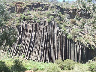
The Organ Pipes National Park, abbreviated as OPNP, is a national park located in the Central region of Victoria, Australia. The 121-hectare (300-acre) protected area was established with the focus on conservation of the native flora and fauna, and preservation of the geological features in the Jacksons Creek, a part of the Maribyrnong valley, north-west of Melbourne. It is situated in a deep gorge in the grassy, basalt Keilor Plains.
Brumby Point is a peak on the remote Nunniong Plateau in the Alpine National Park in Victoria, Australia. Distinct from the similarly named Brumby Hill to the north-west, it is bounded by Reedy Creek Chasm to the north and Little Reedy Creek to the south. The locality has been noted for visible folds in the Ordovician rock. A number of rare plant species occur in the area including Eucalyptus elaeophloia and Leptospermum jingera. The "brumby mallee-gum", recently discovered in this location, was formally described in 2013 and assigned the name Eucalyptus phoenix. The seven kilometre long Brumby Point four wheel drive track which traversed the ridge leading up to the point was earmarked for permanent closure in 1992.

Aboriginal sites of Victoria form an important record of human occupation for probably more than 40,000 years. They may be identified from archaeological remains, historical and ethnographic information or continuing oral traditions and encompass places where rituals and ceremonies were performed, occupation sites where people ate, slept and carried out their day to day chores, and ephemeral evidence of people passing through the landscape, such as a discarded axe head or isolated artefact.
Mount Elizabeth is a mountain to the east of Tambo Crossing in East Gippsland, Victoria, Australia. It lies within the Mount Elizabeth Nature Conservation Reserve managed by Parks Victoria. The reserve, which covers 5,234 hectares, was established in 1984. The reserve is the only known location where the endangered plant species leafy nematolepis occurs. Other rare or vulnerable plant species found in the reserve include Tullach Ard grevillea, outcrop guinea-flower, Mount Elizabeth hovea, monkey mint-bush and leafless pink-bells. Fauna species of note include the lace monitor, yellow-tailed black cockatoo and gang-gang cockatoo.
References
- ↑ Guerrera, Orietta (22 September 2006). "'Secret' Gorge lifts its veil". The Age. Retrieved 20 April 2008.
- ↑ "Tim Read". Environment Victoria. Retrieved 19 April 2008.
37°4′21″S144°32′17″E / 37.07250°S 144.53806°E
| | This article about a location in Victoria, Australia is a stub. You can help Wikipedia by expanding it. |