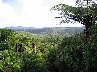
The Waitākere Ranges is a mountain range in New Zealand. Located in West Auckland between metropolitan Auckland and the Tasman Sea, the ranges and its foothills and coasts comprise some 27,720 hectares of public and private land. The area, traditionally known to Māori as Te Wao Nui o Tiriwa, is of local, regional, and national significance. The Waitākere Ranges includes a chain of hills in the Auckland Region, generally running approximately 25 kilometres (16 mi) from north to south, 25 km west of central Auckland. The ranges are part of the Waitākere Ranges Regional Park.

Muriwai, also called Muriwai Beach, is a coastal community on the west coast of the Auckland Region in the North Island of New Zealand. The black-sand surf beach and surrounding area is a popular recreational area for Aucklanders. The Muriwai Regional Park includes a nesting site for a large colony of gannets.

Piha is a coastal settlement in West Auckland, on the western coast of the Auckland Region in New Zealand. It is one of the most popular beaches in the area and a major day-trip destination for Aucklanders throughout the year, and especially in summer.

Karekare is a small coastal settlement in West Auckland, New Zealand, sandwiched between the Waitākere Ranges and a large black sand surf beach.

Anawhata is a beach on the coast of New Zealand west of Auckland.

Te Kawerau ā Maki, Te Kawerau a Maki, or Te Kawerau-a-Maki is a Māori iwi (tribe) of the Auckland Region of New Zealand. Predominantly based in West Auckland, it had 251 registered adult members as of June 2017. The iwi holds land for a new marae and papakāinga at Te Henga that was returned in 2018; and land for a secondary marae at Te Onekiritea that was returned in 2015. it has no wharenui yet.

Hōne Heke Ngāpua was a Māori and Liberal Party Member of Parliament in New Zealand. He was born in Kaikohe, and was named after his great-uncle Hōne Heke. Ngāpua is best remembered for his advocacy for Te Kotahitanga, sponsorship of Māori autonomy in Parliament through a Native Rights Bill, and his successful intervention in the Dog Tax War of 1898.
Lake Wainamu is a small lake near Te Henga in the Auckland Region of New Zealand. It is located south-west of Lake Kawaupaka.

The Waitākere River is a river of the Auckland Region of New Zealand's North Island. It flows north then west from its sources in the Waitākere Ranges, reaching the Tasman Sea at Te Henga / Bethells Beach, to the south of Muriwai Beach. The upper reaches of the river are dammed to form the Waitākere Reservoir. The Waitākere Falls, just below the dam, are 95 metres (312 ft) high and the third highest waterfall in the North Island.

Lion Rock is a rocky headland located on Piha Beach on the western coast of the Auckland Region in New Zealand.

Te Toiokawharu is a hill in the Waitākere Ranges of the Auckland Region of New Zealand's North Island. At 474-metres, it is the tallest peak of the Waitākere Ranges. The peak has a low prominence due to surrounding hills of similar sizes.

The Little Muddy Creek is a river of the Auckland Region of New Zealand's North Island. It flows south from its source in Titirangi, meets the tributaries Waituna Stream and Waiohua Creek which run through the suburbs of Waima and Woodlands Park, before reaching the Manukau Harbour.

The Big Muddy Creek is an estuarine tidal inlet of the Auckland Region of New Zealand's North Island. It flows south from its tributary rivers, the Nihotupu Stream and the Island stream in the Waitākere Ranges which are dammed at the Lower Nihotupu Reservoir, towards the Manukau Harbour.
The Ōpanuku Stream, formerly known as the Henderson Stream, is a stream of the Auckland Region of New Zealand's North Island. It flows east from its source the Waitākere Ranges through the Henderson Valley, then north-east through West Auckland before entering into the Te Wai-o-Pareira / Henderson Creek, which flows into the western the Waitematā Harbour. The stream passes through the rural locality of Henderson Valley and the West Auckland suburbs of Western Heights and Henderson. Since the mid-2000s it has been forested with native flora.

The Kakamatua Inlet is an inlet of the Manukau Harbour of the Auckland Region of New Zealand's North Island.

Te Toka-Tapu-a-Kupe / Ninepin Rock is an island at the mouth of the Manukau Harbour, at Whatipu in the Waitākere Ranges area.

Paratutae Island, also known as Paratūtai Island, is an island off New Zealand at the mouth of the Manukau Harbour, at Whatipu in the Waitākere Ranges area.

Ruaotuwhenua is a hill in the Waitākere Ranges of the Auckland Region of New Zealand's North Island. At 440 metres (1,440 ft), it is one of the tallest of the Waitākere Ranges, and the tallest of the eastern ranges adjacent to Auckland. The peak is the location of an air traffic radome and a radio mast is located further down the slope of the hill in Waiatarua.

Te Unuhanga-a-Rangitoto / Mercer Bay is a bay on the Auckland Region of New Zealand's North Island. It is located south of Piha and north of Karekare. The bay is surrounded by 60 m (200 ft)-high cliffs, which are the tallest in the Auckland Region.

Oaia Island is an island on the west coast of the Auckland Region, New Zealand, near Muriwai. Home to an Australasian gannet colony, the island was traditionally used as a seasonal food resource for Tāmaki Māori iwi, including Te Kawerau ā Maki. Over the 21st century, the gannet population grew significantly, which had a negative impact on the island's flora, and led to gannets colonising areas of the Muriwai mainland. The island is a known location where the rare korowai gecko has been found.


