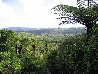
The Waitākere Ranges is a mountain range in New Zealand. Located in West Auckland between metropolitan Auckland and the Tasman Sea, the ranges and its foothills and coasts comprise some 27,720 hectares of public and private land. The area, traditionally known to Māori as Te Wao Nui o Tiriwa, is of local, regional, and national significance. The Waitākere Ranges includes a chain of hills in the Auckland Region, generally running approximately 25 kilometres (16 mi) from north to south, 25 km west of central Auckland. The ranges are part of the Waitākere Ranges Regional Park.

Muriwai, also called Muriwai Beach, is a coastal community on the west coast of the Auckland Region in the North Island of New Zealand. The black-sand surf beach and surrounding area is a popular recreational area for Aucklanders. The Muriwai Regional Park includes a nesting site for a large colony of gannets.

Piha is a coastal settlement in West Auckland, on the western coast of the Auckland Region in New Zealand. It is one of the most popular beaches in the area and a major day-trip destination for Aucklanders throughout the year, and especially in summer.

Karekare is a small coastal settlement in West Auckland, New Zealand, sandwiched between the Waitākere Ranges and a large black sand surf beach.

Anawhata is a beach on the coast of New Zealand west of Auckland.

Kitekite Falls is a scenic 3-tiered waterfall near Auckland, New Zealand. The falls drop a total of 40 metres (130 ft). From the lookout on Kitekite track the falls appear even higher because there is white water running over rocks into a small pool from the upper swimming hole, then falling down into a large pool, then falling to a small pool before beginning an almost vertical descent in the final 3-tiers, making the total height closer to 80 metres (260 ft). They are located on the Glen Esk Stream near Piha Beach.

Te Kawerau ā Maki, Te Kawerau a Maki, or Te Kawerau-a-Maki is a Māori iwi (tribe) of the Auckland Region of New Zealand. Predominantly based in West Auckland, it had 251 registered adult members as of June 2017. The iwi holds land for a new marae and papakāinga at Te Henga that was returned in 2018; and land for a secondary marae at Te Onekiritea that was returned in 2015. it has no wharenui yet.

Oratia is a semi-rural locality on the western edge of metropolitan West Auckland in New Zealand.
Lake Wainamu is a small lake near Te Henga in the Auckland Region of New Zealand. It is located south-west of Lake Kawaupaka.

Lion Rock is a rocky headland located on Piha Beach in the Waitākere Ranges area of the Auckland Region, New Zealand.

Te Toiokawharu is a hill in the Waitākere Ranges of the Auckland Region of New Zealand's North Island. At 474-metres, it is the tallest peak of the Waitākere Ranges. The peak has a low prominence due to surrounding hills of similar sizes.

West Auckland is one of the major geographical areas of Auckland, the largest city in New Zealand. Much of the area is dominated by the Waitākere Ranges, the eastern slopes of the Miocene era Waitākere volcano which was upraised from the ocean floor, and now one of the largest regional parks in New Zealand. The metropolitan area of West Auckland developed between the Waitākere Ranges to the west and the upper reaches of the Waitematā Harbour to the east. It covers areas such as Glen Eden, Henderson, Massey and New Lynn.
The Ōpanuku Stream, formerly known as the Henderson Stream, is a stream of the Auckland Region of New Zealand's North Island. It flows east from its source the Waitākere Ranges through the Henderson Valley, then north-east through West Auckland before entering into the Te Wai-o-Pareira / Henderson Creek, which flows into the western the Waitematā Harbour. The stream passes through the rural locality of Henderson Valley and the West Auckland suburbs of Western Heights and Henderson. Since the mid-2000s it has been forested with native flora.

The Kakamatua Inlet is an inlet of the Manukau Harbour of the Auckland Region of New Zealand's North Island.

O'Neill Bay is a bay on the Auckland Region of New Zealand's North Island. It is located north of Te Henga / Bethells Beach.

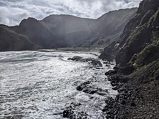
Paratutae Island, also known as Paratūtai Island, is an island off New Zealand at the mouth of the Manukau Harbour, at Whatipu in the Waitākere Ranges area.

Pukematekeo is a hill in the Waitākere Ranges of the Auckland Region of New Zealand's North Island. It is located west of Henderson, and is the northernmost hill in the Waitākere Ranges Regional Park.

Arataki Visitor Centre is a tourism and education centre in West Auckland, New Zealand, often described as the gateway to the Waitākere Ranges. The centre provides information about the Waitākere Ranges, and organises educational events.
Whites Beach is a small beach on the west coast of the Auckland Region of New Zealand's North Island. It is located between Piha and Anawhata.

Piha Stream is a stream of the Auckland Region of New Zealand's North Island. It flows westwards from its sources in the Waitākere Ranges through Piha village, and enters the Tasman Sea south of Lion Rock.

