Greater Wellington, also known as the Wellington Region, is a non-unitary region of New Zealand that occupies the southernmost part of the North Island. The region covers an area of 8,049 square kilometres (3,108 sq mi), and has a population of 550,600.

The South Wairarapa District is a district at the south-east tip of the North Island of New Zealand, governed by the South Wairarapa District Council. The district comprises the southernmost part of the Wairarapa, and is part of the Wellington Region.

Auckland is one of the 16 regions of New Zealand, which takes its name from the eponymous urban area. The region encompasses the Auckland metropolitan area, smaller towns, rural areas, and the islands of the Hauraki Gulf. Containing 34 percent of the nation's residents, it has by far the largest population and economy of any region of New Zealand, but the second-smallest land area.

Horowhenua District is a territorial authority district on the west coast of the North Island of New Zealand, administered by Horowhenua District Council. Located north of Wellington and Kāpiti, it stretches from slightly north of the town of Ōtaki in the south to just south of Himatangi in the north, and from the coast to the top of the Tararua Range. It is in the Manawatū-Whanganui local government region. The name Horowhenua is Māori for landslide.

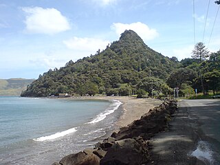
The Thames-Coromandel District is a territorial authority district in the North Island of New Zealand, covering all the Coromandel Peninsula and extending south to Hikutaia.

Hauraki District is a territorial authority governed by the Hauraki District Council within the Waikato region of New Zealand. The seat of the council is at Paeroa.

Waikato District is a territorial authority of New Zealand, in the northern part of Waikato region, North Island. Waikato District is administered by the Waikato District Council, with headquarters in Ngāruawāhia.

Southland District is a New Zealand territorial authority district that covers most of the southern end of the South Island as well as Stewart Island.

Titirangi is a suburb of West Auckland in the Waitākere Ranges local board area of the city of Auckland in northern New Zealand. It is an affluent, residential suburb located 13 km (8.1 mi) to the southwest of the Auckland city centre, at the southern end of the Waitākere Ranges. In the Māori language "Titirangi" means "hill reaching up to the sky".

Karekare is a small coastal settlement in West Auckland, New Zealand, sandwiched between the Waitākere Ranges and a large black sand surf beach.

Central Otago District is local government district in New Zealand. It is administered by the Central Otago District Council, and it is in the Otago region, the top tier of local government in New Zealand. The major towns in the district are Alexandra, Cromwell, Roxburgh, Clyde and Ranfurly. The district covers 9,968 km2 (3,849 sq mi), making it the fourth-largest district in New Zealand by area, and is home to 26,500 people as of June 2024.

Westland District is a territorial authority district on the West Coast of New Zealand's South Island. It is administered by the Westland District Council. The district's population is 9,430.
Grey District is a district in the West Coast Region of New Zealand that covers Greymouth, Runanga, Blackball, Cobden, and settlements along the Grey River. It has a land area of 3,474.31 square kilometres (1,341.44 sq mi). The seat of the Grey District Council, the local government authority that administers the district, is at Greymouth, where 58.4% of the district's population live.

Clutha District is a local government district of southern New Zealand, with its headquarters in the Otago town of Balclutha. Clutha District has a land area of 6,334.47 km2 (2,445.75 sq mi) and an estimated population of 19,300 as of June 2024. Clutha District occupies the majority of the geographical area known as South Otago.

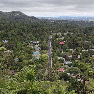
Waiatarua is a small settlement near the top of the Waitākere Ranges in West Auckland, close to the junction of Scenic Drive, West Coast Road and Piha Road to Piha and runs east until the junction of Scenic Drive and Mountain Road. Surrounded by native bush in the Centennial Memorial Park and the water catchment area, Waiatarua is over 300 metres above sea level and some houses are over 400 metres above sea level. Waiatarua means “song of two waters”, possibly referring to the ability to see both the wild west coast, and the still, sparkling waters of the Manukau and Waitemata harbours from certain points in the area.
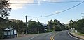
Woodlands Park is a suburb on the western outskirts of West Auckland, New Zealand. Nestled in the Waitākere Ranges, Woodlands Park lies in a valley, bush clad hills separating it from Titirangi, Parau and Huia and Laingholm.

Taupō District is a territorial authority district in New Zealand. It covers 6,333 km² of land, and a further 610 km² of lake area, including Lake Taupō, New Zealand's largest lake, and Lake Rotoaira. The district stretches from the small town of Mangakino in the northwest to the Tongariro National Park in the south, and east into the Kaingaroa Forest. The district's population is largely located in the two main centres, Taupō and Tūrangi.

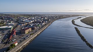
Whangarei District is a territorial authority district in the Northland Region of New Zealand that is governed by the Whangarei District Council. The district is made up in area largely by rural land, and includes a fifth of the Northland Region. It extends southwards to the southern end of Bream Bay, northwards to Whangaruru and almost to the Bay of Islands, and westwards up the Mangakahia River valley past Pakotai and almost to Waipoua Forest. It includes the Hen and Chicken Islands and the Poor Knights Islands.

Ashburton District is a territorial authority district in the Canterbury Region of the South Island of New Zealand. It encompasses the town of Ashburton, a number of small towns and settlements and the surrounding rural area, roughly coterminous with Mid Canterbury. The district had a population of 38,400 as of June 2024.
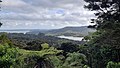
Little Huia is a western coastal settlement of West Auckland, Auckland, New Zealand and forms part of the Waitākere Ranges Regional Park, bordering the Manukau Harbour. It is located south-west of the settlement of Huia.