
Waitākere City was a territorial authority in West Auckland, New Zealand; it was governed by the Waitākere City Council from 1989 to 2010. It was New Zealand's fifth-largest city, with an annual growth of about 2%. In 2010 the council was amalgamated with the other authorities of the Auckland Region to form the current Auckland Council.
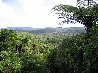
The Waitākere Ranges is a mountain range in New Zealand. Located in West Auckland between metropolitan Auckland and the Tasman Sea, the ranges and its foothills and coasts comprise some 27,720 hectares of public and private land. The area, traditionally known to Māori as Te Wao Nui o Tiriwa, is of local, regional, and national significance. The Waitākere Ranges includes a chain of hills in the Auckland Region, generally running approximately 25 kilometres (16 mi) from north to south, 25 km west of central Auckland. The ranges are part of the Waitākere Ranges Regional Park.

Muriwai, also called Muriwai Beach, is a coastal community on the west coast of the Auckland Region in the North Island of New Zealand. The black-sand surf beach and surrounding area is a popular recreational area for Aucklanders. The Muriwai Regional Park includes a nesting site for a large colony of gannets.

Piha is a coastal settlement in West Auckland, on the western coast of the Auckland Region in New Zealand. It is one of the most popular beaches in the area and a major day-trip destination for Aucklanders throughout the year, and especially in summer.

Karekare is a small coastal settlement in West Auckland, New Zealand, sandwiched between the Waitākere Ranges and a large black sand surf beach.

Te Henga, or Bethells Beach, is a coastal community in West Auckland, New Zealand. The Māori name for the area, "Te Henga", is in reference to the long foredunes which run along the beach and look like the Henga or gunwale of an upturned waka hull. This name originally applied to a wide area of the lower Waitakere River valley, but during the early 1900s the area became popular with visiting European immigrants who began to refer to the area as "Bethells Beach" after the Bethell Family who live there and still own much of the area. In 1976 the New Zealand Geographic Board officially named the area "Te Henga ".

Te Kawerau ā Maki, Te Kawerau a Maki, or Te Kawerau-a-Maki is a Māori iwi (tribe) of the Auckland Region of New Zealand. It had 251 registered adult members as of June 2017. Auckland Council gave it land for a marae at Te Henga in 2018; it has no wharenui yet.
Lake Wainamu is a small lake near Te Henga in the Auckland Region of New Zealand. It is located south-west of Lake Kawaupaka.

The Waitākere River is a river of the Auckland Region of New Zealand's North Island. It flows north then west from its sources in the Waitākere Ranges, reaching the Tasman Sea at Te Henga / Bethells Beach, to the south of Muriwai Beach. The upper reaches of the river are dammed to form the Waitākere Reservoir. The Waitākere Falls, just below the dam, are 95 metres (312 ft) high and the third highest waterfall in the North Island.

Lake Kawaupaka, also known as Lake Kawaupaku, is a small lake near Te Henga in the Auckland Region of New Zealand. The lake is on private land, and is one of the few dune lakes in the region to be surrounded by native forest. It is located south-west of Lake Wainamu.

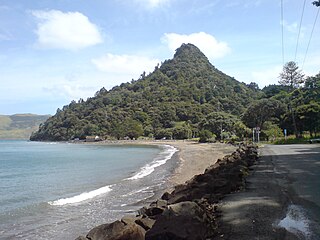
Lion Rock is a rocky headland located on Piha Beach in the Waitākere Ranges area of the Auckland Region, New Zealand.

West Auckland is one of the major geographical areas of Auckland, the largest city in New Zealand. Much of the area is dominated by the Waitākere Ranges, the eastern slopes of the Miocene era Waitākere volcano which was upraised from the ocean floor, and one of the largest regional parks in New Zealand. The metropolitan area of West Auckland developed on the lands between the Waitākere Ranges to the west and the upper reaches of the Waitematā Harbour to the east, in areas such as Massey, Henderson, New Lynn and Glen Eden.

The Big Muddy Creek is an estuarine tidal inlet of the Auckland Region of New Zealand's North Island. It flows south from its tributary rivers, the Nihotupu Stream and the Island stream in the Waitākere Ranges which are dammed at the Lower Nihotupu Reservoir, towards the Manukau Harbour.

The Swanson Stream is a stream of the Auckland Region of New Zealand's North Island. It flows north-east from its source the Waitākere Ranges through rural West Auckland towards the suburb of Swanson, before joining the Momutu Stream, which exits into Te Wai-o-Pareira / Henderson Creek and the western the Waitematā Harbour. Since the mid-2000s has been forested with native flora.
Little Huia is a western coastal settlement of West Auckland, Auckland, New Zealand and forms part of the Waitākere Ranges Regional Park, bordering the Manukau Harbour. It is located south-west of the settlement of Huia.

The Kakamatua Inlet is an inlet of the Manukau Harbour of the Auckland Region of New Zealand's North Island.

O'Neill Bay is a bay on the Auckland Region of New Zealand's North Island. It is located north of Te Henga / Bethells Beach.

Paratutae Island, also known as Paratūtai Island, is an island at the mouth of the Manukau Harbour, at Whatipu in the Waitākere Ranges area.

Paorae is the name of a migrating coastal dune, formerly located west of the Āwhitu Peninsula in the Auckland Region of New Zealand. Paorae was an important area for cultivating kūmara and taro for Tāmaki Māori tribes Ngāiwi and Ngāoho, and later Waikato Tainui. The land eroded in the 18th century, becoming known as a legendary "Māori Atlantis" to European New Zealanders. Material from Paorae forms the Manukau Heads sandbars and the modern day beach at Whatipu, which began forming in the 1930s.

The Goldie Bush Scenic Reserve, also known as Goldies Bush and Te Taiapa, is a forested area of West Auckland, New Zealand. Located south-east of Muriwai, the reserve is home to the Mokoroa Falls.


