Henderson Valley

Last updated

Henderson Valley
Waitakere Ranges and Henderson Valley.jpg
Henderson Valley seen from the Waitākere Ranges
Henderson Valley
Coordinates: 36°54′25″S174°35′13″E / 36.907°S 174.587°E / -36.907; 174.587
Country New Zealand
Region Auckland
Ward Waitākere ward
Local board Waitākere Ranges Local Board
Electorates
Government
  Territorial Authority Auckland Council
Area
[1]
  Total
15.04 km2 (5.81 sq mi)
Population
 (June 2024) [2]
  Total
1,440
  Density96/km2 (250/sq mi)

Henderson Valley is a locality in West Auckland, New Zealand. The major road in the locality is Henderson Valley Road, and Scenic Drive is on the western boundary. [3]

Contents

History

The Henderson Valley is in the traditional rohe of Te Kawerau ā Maki, [4] and was traditionally known as Ōpanuku. [5] Ōpanuku refers to one of the oldest Te Kawerau ā Maki ancestors, Panuku, the wife of Parekura who died after being kidnapped by a warrior named Nihotupu. [6] [4] Te Kawerau ā Maki had a settlement along the Opanuku Stream known as Ōpareira. [6] The name refers to Pareira, the niece of early ancestor and voyager Toi-te-huatahi. Pareira lived at Te Wai-o-Pareira / Henderson Creek and would seasonally inhabit the Henderson Valley, harvesting the resources of the forest. [6]

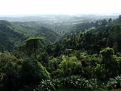
The Opanuku Stream which flows down the valley was one of the earliest waterways to be dammed for kauri logging in West Auckland, in the 1850s. [7] The valley was settled by pākehā by the 1880s, with Henderson Valley Road providing access. [8] [9]

In the 1920s, the Henderson Valley Scenic Reserve/Carey Park was a popular picnic and swimming area known as Ferndale, where the Brown Owl Tea Rooms was located. [10]

Demographics

Henderson Valley statistical area covers 15.04 km2 (5.81 sq mi) [1] and had an estimated population of 1,440 as of June 2024, [2] with a population density of 96 people per km2.

Historical population
YearPop.±% p.a.
20061,341    
20131,353+0.13%
20181,440+1.25%
20231,422−0.25%
Source: [11] [12]
Fairy Falls which flow into a tributary of the Opanuku Stream Henderson Valley, Auckland, New Zealand - panoramio (1).jpg
Fairy Falls which flow into a tributary of the Ōpanuku Stream

Henderson Valley had a population of 1,422 in the 2023 New Zealand census, a decrease of 18 people (−1.2%) since the 2018 census, and an increase of 69 people (5.1%) since the 2013 census. There were 735 males, 678 females and 12 people of other genders in 489 dwellings. [13] 4.2% of people identified as LGBTIQ+. The median age was 42.5 years (compared with 38.1 years nationally). There were 264 people (18.6%) aged under 15 years, 237 (16.7%) aged 15 to 29, 726 (51.1%) aged 30 to 64, and 198 (13.9%) aged 65 or older. [12]

People could identify as more than one ethnicity. The results were 86.9% European (Pākehā); 14.3% Māori; 7.8% Pasifika; 7.4% Asian; 0.8% Middle Eastern, Latin American and African New Zealanders (MELAA); and 2.3% other, which includes people giving their ethnicity as "New Zealander". English was spoken by 97.9%, Māori language by 1.9%, Samoan by 1.5%, and other languages by 12.2%. No language could be spoken by 1.3% (e.g. too young to talk). New Zealand Sign Language was known by 0.6%. The percentage of people born overseas was 23.6, compared with 28.8% nationally.

Religious affiliations were 25.9% Christian, 0.2% Hindu, 0.4% Islam, 0.6% Māori religious beliefs, 0.4% Buddhist, 0.4% New Age, and 1.3% other religions. People who answered that they had no religion were 62.2%, and 8.4% of people did not answer the census question.

Of those at least 15 years old, 318 (27.5%) people had a bachelor's or higher degree, 636 (54.9%) had a post-high school certificate or diploma, and 207 (17.9%) people exclusively held high school qualifications. The median income was $49,400, compared with $41,500 nationally. 201 people (17.4%) earned over $100,000 compared to 12.1% nationally. The employment status of those at least 15 was that 630 (54.4%) people were employed full-time, 177 (15.3%) were part-time, and 30 (2.6%) were unemployed. [12]

Education

Henderson Valley School is a coeducational contributing primary (years 1-6) school with a roll of 352 students as of November 2024. [14] [15] The school opened in 1915. [16]

Notes

  1. 1 2 "Stats NZ Geographic Data Service". Statistical Area 2 2023 (generalised). Retrieved 4 January 2025.
  2. 1 2 "Aotearoa Data Explorer". Statistics New Zealand . Retrieved 26 October 2024.
  3. Topo50 map BA31 - Waitemata Harbour (Map). 1:50,000. Land Information New Zealand. 2016.
  4. 1 2 "Opanuku Stream" (PDF). Project Twin Streams. Auckland Council. 2012. Retrieved 1 May 2022.
  5. "Opanuku Stream". New Zealand Gazetteer. Land Information New Zealand. Retrieved 1 May 2022.
  6. 1 2 3 Te Kawerau ā Maki; The Trustees of Te Kawerau Iwi Settlement Trust; The Crown (12 December 2013). "Deed of Settlement Schedule: Documents" (PDF). Archived from the original (PDF) on 9 June 2022. Retrieved 26 April 2022.
  7. Hayward, B. W.; Diamond, J. T. (1975). "Kauri Dam Sites in the Waitakere Ranges" (PDF). Tane. 6: 105–120. Retrieved 3 May 2022.
  8. "Untitled". Auckland Star. 23 January 1886. p. 2.
  9. "Untitled". New Zealand Herald. 15 June 1886. p. 4.
  10. Jones, Philippa (2002). "Opanuku: From Source to Sea". New Zealand Geographic . Retrieved 1 May 2022.
  11. "Statistical area 1 dataset for 2018 Census". Statistics New Zealand. March 2020. Henderson Valley (124700). 2018 Census place summary: Henderson Valley
  12. 1 2 3 "Totals by topic for individuals, (RC, TALB, UR, SA3, SA2, Ward, Health), 2013, 2018, and 2023 Censuses". Stats NZ – Tatauranga Aotearoa – Aotearoa Data Explorer. Henderson Valley (124700). Retrieved 3 October 2024.
  13. "Totals by topic for dwellings, (RC, TALB, UR, SA3, SA2, Ward, Health), 2013, 2018, and 2023 Censuses". Stats NZ – Tatauranga Aotearoa – Aotearoa Data Explorer. Retrieved 3 October 2024.
  14. "New Zealand Schools Directory". New Zealand Ministry of Education. Retrieved 1 January 2025.
  15. Education Counts: Henderson Valley School
  16. "Our Story". Henderson Valley School. Retrieved 27 June 2020.

Related Research Articles

<span class="mw-page-title-main">North Shore, New Zealand</span> Subregion of Auckland, New Zealand

The North Shore is one of the major geographical regions of Auckland, the largest city in New Zealand. The area is defined as the northern shores of the Waitematā Harbour as far north as the Ōkura River.

<span class="mw-page-title-main">Henderson, New Zealand</span> Suburb in Auckland, New Zealand

Henderson is a suburb of Auckland, New Zealand. It is 13 kilometres (8.1 mi) west of Auckland city centre, and two kilometres (1.2 mi) west of the Whau River, a southwestern arm of the Waitematā Harbour.

<span class="mw-page-title-main">Waitākere Ranges</span> Mountain range on the North Island of New Zealand

The Waitākere Ranges is a mountain range in New Zealand. Located in West Auckland between metropolitan Auckland and the Tasman Sea, the ranges and its foothills and coasts comprise some 27,720 hectares of public and private land. The area, traditionally known to Māori as Te Wao Nui o Tiriwa, is of local, regional, and national significance. The Waitākere Ranges includes a chain of hills in the Auckland Region, generally running approximately 25 kilometres (16 mi) from north to south, 25 km west of central Auckland. The ranges are part of the Waitākere Ranges Regional Park.

<span class="mw-page-title-main">Orewa</span> Suburb in Auckland, New Zealand

Orewa is a settlement in the northern Auckland Region of New Zealand. It is a suburb of the Hibiscus Coast, just north of the base of the Whangaparāoa Peninsula and 40 kilometres (25 mi) north of central Auckland. The Northern Motorway, part of State Highway 1, passes just inland of Orewa and extends through the twin Johnston Hill tunnels to near Puhoi.

<span class="mw-page-title-main">Karekare, New Zealand</span> Place in Auckland Region, New Zealand

Karekare is a small coastal settlement in West Auckland, New Zealand, sandwiched between the Waitākere Ranges and a large black sand surf beach.

<span class="mw-page-title-main">Kumeū</span> Place in Auckland Region, New Zealand

Kumeū is a town in the Auckland Region, situated 25 kilometres (16 mi) north-west of the City Centre in New Zealand. State Highway 16 and the North Auckland Line pass through the town. Huapai lies to the west, Riverhead to the north, Whenuapai to the east, and Taupaki to the south.

<span class="mw-page-title-main">Greenhithe, New Zealand</span> Suburb in Auckland, New Zealand

Greenhithe is a northwestern suburb of Auckland, New Zealand, located on the North Shore. Greenhithe was the location of Tauhinu, a fortified Te Kawerau ā Maki and Ngāti Whātua pā which overlooked the entrance to Oruamo or Hellyers Creek, that was settled until the 1820s. In the 1860s, the Forgham family established a community at Greenhithe, which by the 1880s had become a major fruit producer for Auckland. Boat repair and construction became major industries in Greenhithe in the 1960s.

<span class="mw-page-title-main">Torbay, New Zealand</span> Suburb in Auckland, New Zealand

Torbay is a northern suburb of Auckland, New Zealand. It is located in the upper East Coast Bays of the city's North Shore, and is governed by Auckland Council.

<span class="mw-page-title-main">Te Atatū South</span> Suburb in Auckland, New Zealand

Te Atatū South is a residential suburb in West Auckland, New Zealand. Its location allows the suburb easy access to the city and Henderson town centre. Its elevation allows views back on to the city and Waitākere Ranges. Situated on the Te Atatū Peninsula, it has coasts backing on to water on its eastern and western sides with walkways and cycleways on both sides.

<span class="mw-page-title-main">Te Atatū Peninsula</span> Suburb in Auckland, New Zealand

Te Atatū Peninsula is a waterfront suburb of West Auckland surrounded by the Waitematā Harbour. The area was home to brickworks and farmland until the Northwestern Motorway was constructed in the 1950s, after which Te Atatū developed a low and medium-cost suburb. The area south of the motorway became known as Te Atatū South. The Auckland Harbour Board intended to develop a port on the peninsula for much of the 20th century. After plans for this were abandoned, the land was redeveloped into Footrot Flats Fun Park, an amusement park which operated in the 1980s. During the late 2010s, large-scale housing intensification led to the population of Te Atatū greatly expanding.

<span class="mw-page-title-main">Massey, New Zealand</span> Suburb in Auckland, New Zealand

Massey is a northern suburb in West Auckland, New Zealand. It was formerly a northern suburb of Waitakere City, which existed from 1989 to 2010 before the city was amalgamated into Auckland Council. The suburb was named after former Prime Minister of New Zealand William Massey. Massey is a relatively large suburb and can be divided into three reasonably distinctive areas, Massey West, Massey East and Massey North. Parts of Massey East are also known as 'Royal Heights', which is home to the Royal Heights shopping centre.

<span class="mw-page-title-main">Waiatarua</span> Place in Auckland, New Zealand

Waiatarua is a small settlement near the top of the Waitākere Ranges in West Auckland, close to the junction of Scenic Drive, West Coast Road and Piha Road to Piha and runs east until the junction of Scenic Drive and Mountain Road. Surrounded by native bush in the Centennial Memorial Park and the water catchment area, Waiatarua is over 300 metres above sea level and some houses are over 400 metres above sea level. Waiatarua means “song of two waters”, possibly referring to the ability to see both the wild west coast, and the still, sparkling waters of the Manukau and Waitemata harbours from certain points in the area.

<span class="mw-page-title-main">Riverhead, New Zealand</span> Place in Auckland Region, New Zealand

Riverhead is a small, historically predominantly working-class town located at the head of the Waitematā Harbour in the north-west of Auckland, New Zealand. It is located on the northwestern shores of the Upper Waitematā Harbour, north-east of the towns of Kumeū and Huapai.

<span class="mw-page-title-main">Castor Bay</span> Suburb in Auckland, New Zealand

Castor Bay is a bay and suburb of the North Shore, located in Auckland which is in the North Island of New Zealand. Located between Milford and Campbells Bay, it is part of the East Coast Bays. To the east lies the islands of Rangitoto and Motutapu, which are easily visible from land. The suburb is in the North Shore ward, one of the thirteen administrative divisions of Auckland Council.

<span class="mw-page-title-main">Waimauku</span> Place in Auckland, New Zealand

Waimauku is a small locality in the Auckland Region of New Zealand. It comes under the jurisdiction of Auckland Council, and is in the council's Rodney ward. Waimauku is approximately 4 kilometres west of Huapai on State Highway 16 at the junction with the road to Muriwai Beach. Helensville is 16 km to the north-west. Waimauku is a Māori word which is literally translated as wai: stream and mauku: varieties of small ferns.

<span class="mw-page-title-main">Murrays Bay</span> Suburb in Auckland, New Zealand

Murrays Bay is a small suburb in the East Coast Bays region, located in the North Shore of Auckland. The suburb is roughly the same size as Rothesay Bay, the suburb to the immediate north. It is primarily a residential area but does have a community centre, restaurant and café. Murrays Bay is regularly serviced by buses which go to Takapuna and the Auckland city centre.

<span class="mw-page-title-main">Taupaki</span> Place in Auckland, New Zealand

Taupaki is a locality in the Rodney District, which is a part of the Auckland Region in New Zealand. Kumeū lies to the north-west, Whenuapai to the north-east, West Harbour to the east, Massey to the south-east, Swanson to the south, and Waitākere, Auckland to the south-west. The North Auckland Line runs through the area.

<span class="mw-page-title-main">Waitākere, New Zealand</span> Suburb in Auckland, New Zealand

Waitākere, often called Waitākere Township, is a small, mostly rural settlement to the northwest of Auckland, New Zealand.

<span class="mw-page-title-main">Swanson, New Zealand</span> Suburb in Auckland, New Zealand

Swanson is an outlying suburb of West Auckland, New Zealand and is located west of Henderson, surrounded by the Waitākere Ranges. Developing as a service centre for the kauri logging and gumdigging trades in the 1880s along the trainline, the town developed as a rural centre and an early tourist destination for Aucklanders, who visited the Redwood Park on the banks of the Swanson Stream. In the 1940s, the park became a training centre for soldiers in World War II, and in 1970 hosted Redwood 70, the first modern music festival in New Zealand.

<span class="mw-page-title-main">Little Huia</span> Coastal settlement in West Auckland, New Zealand

Little Huia is a western coastal settlement of West Auckland, Auckland, New Zealand and forms part of the Waitākere Ranges Regional Park, bordering the Manukau Harbour. It is located south-west of the settlement of Huia.