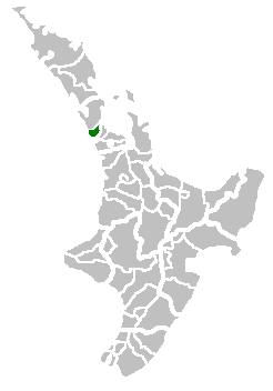
Waitākere City was a territorial authority in West Auckland, New Zealand; it was governed by the Waitākere City Council from 1989 to 2010. It was New Zealand's fifth-largest city, with an annual growth of about 2%. In 2010 the council was amalgamated with the other authorities of the Auckland Region to form the current Auckland Council.
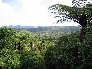
The Waitākere Ranges is a mountain range in New Zealand. Located in West Auckland between metropolitan Auckland and the Tasman Sea, the ranges and its foothills and coasts comprise some 27,720 hectares of public and private land. The area, traditionally known to Māori as Te Wao Nui o Tiriwa, is of local, regional, and national significance. The Waitākere Ranges includes a chain of hills in the Auckland Region, generally running approximately 25 kilometres (16 mi) from north to south, 25 km west of central Auckland. The ranges are part of the Waitākere Ranges Regional Park.

Piha is a coastal settlement in West Auckland, on the western coast of the Auckland Region in New Zealand. It is one of the most popular beaches in the area and a major day-trip destination for Aucklanders throughout the year, and especially in summer.

Karekare is a small coastal settlement in West Auckland, New Zealand, sandwiched between the Waitākere Ranges and a large black sand surf beach.

Anawhata is a beach on the coast of New Zealand west of Auckland.

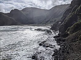
Whatipu is a remote beach on the west coast of the Auckland Region in the North Island of New Zealand. The Whatipu area has been managed as a scientific reserve by the Auckland Regional Council since 2002. The road to it is unsealed. To the south of Whatipu is Manukau Harbour. To the north is Karekare. Whatipu is located at the southern end of the Waitākere Ranges. Shifting sands have substantially changed the beach since the 1940s. Over 6 square kilometres has been added to the beach since then.

Scenic Drive is a road that runs through the bush-clad Waitākere Ranges from Titirangi to Swanson on the western outskirts of Auckland, New Zealand. It is part of Auckland urban route 24. As the name indicates, it is famous for the sweeping views over the western parts of the Auckland Region.

Kitekite Falls is a scenic 3-tiered waterfall near Auckland, New Zealand. The falls drop a total of 40 metres (130 ft). From the lookout on Kitekite track the falls appear even higher because there is white water running over rocks into a small pool from the upper swimming hole, then falling down into a large pool, then falling to a small pool before beginning an almost vertical descent in the final 3-tiers, making the total height closer to 80 metres (260 ft). They are located on the Glen Esk Stream near Piha Beach.
Lake Wainamu is a small lake near Te Henga in the Auckland Region of New Zealand. It is located south-west of Lake Kawaupaka.

The Auckland Region of New Zealand is built on a basement of greywacke rocks that form many of the islands in the Hauraki Gulf, the Hunua Ranges, and land south of Port Waikato. The Waitākere Ranges in the west are the remains of a large andesitic volcano, and Great Barrier Island was formed by the northern end of the Coromandel Volcanic Zone. The Auckland isthmus and North Shore are composed of Waitemata sandstone and mudstone, and portions of the Northland Allochthon extend as far south as Albany. Little Barrier Island was formed by a relatively isolated andesitic volcano, active around 1 to 3 million years ago.

Lion Rock is a rocky headland located on Piha Beach in the Waitākere Ranges area of the Auckland Region, New Zealand.

Te Toiokawharu is a hill in the Waitākere Ranges of the Auckland Region of New Zealand's North Island. At 474-metres, it is the tallest peak of the Waitākere Ranges. The peak has a low prominence due to surrounding hills of similar sizes.

The Kakamatua Inlet is an inlet of the Manukau Harbour of the Auckland Region of New Zealand's North Island.

O'Neill Bay is a bay on the Auckland Region of New Zealand's North Island. It is located north of Te Henga / Bethells Beach.

Pukematekeo is a hill in the Waitākere Ranges of the Auckland Region of New Zealand's North Island. It is located west of Henderson, and is the northernmost hill in the Waitākere Ranges Regional Park.

The Goldie Bush Scenic Reserve, also known as Goldies Bush and Te Taiapa, is a forested area of West Auckland, New Zealand. Located south-east of Muriwai, the reserve is home to the Mokoroa Falls.

Arataki Visitor Centre is a tourism and education centre in West Auckland, New Zealand, often described as the gateway to the Waitākere Ranges. The centre provides information about the Waitākere Ranges, and organises educational events.

Te Rau-o-te-Huia / Mount Donald McLean is a hill in the Waitākere Ranges of the Auckland Region of New Zealand's North Island. It is located to the south of the ranges, near the township of Huia. It is the highest peak of the Waitākere Ranges that borders the Manukau Harbour.

Te Unuhanga-a-Rangitoto / Mercer Bay is a bay on the Auckland Region of New Zealand's North Island. It is located south of Piha and north of Karekare. The bay is surrounded by 60 m (200 ft)-high cliffs, which are the tallest in the Auckland Region.

Piha Stream is a stream of the Auckland Region of New Zealand's North Island. It flows westwards from its sources in the Waitākere Ranges through Piha village, and enters the Tasman Sea south of Lion Rock.