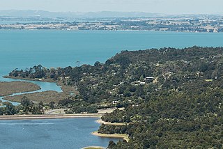
The Manukau Harbour is the second largest natural harbour in New Zealand by area. It is located to the southwest of the Auckland isthmus, and opens out into the Tasman Sea.

Titirangi is a suburb of West Auckland in the Waitākere Ranges local board area of the city of Auckland in northern New Zealand. It is an affluent, residential suburb located 13 kilometres to the southwest of the Auckland city centre, at the southern end of the Waitākere Ranges. In the Māori language "Titirangi" means "long streaks of cloud in the sky", but this is often given as "fringe of heaven".
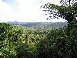
The Waitākere Ranges is a mountain range in New Zealand. Located in West Auckland between metropolitan Auckland and the Tasman Sea, the ranges and its foothills and coasts comprise some 27,720 hectares of public and private land. The area, traditionally known to Māori as Te Wao Nui o Tiriwa, is of local, regional, and national significance. The Waitākere Ranges includes a chain of hills in the Auckland Region, generally running approximately 25 kilometres (16 mi) from north to south, 25 km west of central Auckland. The ranges are part of the Waitākere Ranges Regional Park.
Western Springs is a residential suburb and park in the city of Auckland in the north of New Zealand. It is located four kilometres to the west of the city centre, Auckland CBD. The park is situated to the north of State Highway 16 and the residential suburb is located southeast of the park on the opposite side of State Highway 16.

The Hunua Ranges is a mountain range and regional park to the southeast of Auckland city, in the Auckland and Waikato regions of New Zealand's North Island. The ranges cover some 250 square kilometres (97 sq mi) and rise to 688 metres (2255 ft) at Kohukohunui.

Te Henga, or Bethells Beach, is a coastal community in West Auckland, New Zealand. The Māori name for the area "Te Henga" is in reference to the long foredunes which run along the beach and look like the Henga or "Gunwhale" of an upturned waka hull. This name originally applied to a wide area of the lower Waitakere River valley, but during the early 1900s the area became popular with visiting European immigrants who began to refer to the area as "Bethells Beach" after the Bethell Family who live there and still own much of the area. In 1976 the New Zealand Geographic Board officially named the area "Te Henga ".

Huia is a western coastal settlement in West Auckland, New Zealand and forms part of the Waitākere Ranges Regional Park. The majority of houses in Huia are located along Huia Road, which arcs around Huia Bay and heads west towards Little Huia.
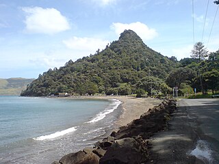
Parau is a locality of West Auckland in the Auckland Region. It is under the local governance of the Waitākere Ranges Local Board within the Auckland Council. It is a coastal community close to Titirangi village. Parau is made up of Huia Road, one other looping street called Rauhuia Crescent and two cul de sacs, Staley Road and Shirley Road. It also consists of a safe clean beach called Armour Bay where locals can partake in tennis, and swimming in the Manukau Harbour which laps the beach.

The Lower Nihotupu Reservoir is one of five reservoirs in the Waitākere Ranges that supply water to Auckland. Built between 1945 and 1948, the reservoir covers an area of 52.9 hectares and has a capacity of 4.6 million cubic metres. The reservoir is managed by Watercare Services, a council-owned company.
Lake Wainamu is a small lake near Te Henga in the Auckland Region of New Zealand. It is located south-west of Lake Kawaupaka.

The Waitākere River is a river of the Auckland Region of New Zealand's North Island. It flows north then west from its sources in the Waitākere Ranges, reaching the Tasman Sea at Te Henga / Bethells Beach, to the south of Muriwai Beach. The upper reaches of the river are dammed to form the Waitākere Reservoir. The Waitākere Falls, just below the dam, are 95 metres (312 ft) high and the third highest waterfall in the North Island.

Lake Kawaupaka, also known as Lake Kawaupaku, is a small lake near Te Henga in the Auckland Region of New Zealand. The lake is on private land, and is one of the few dune lakes in the region to be surrounded by native forest. It is located south-west of Lake Wainamu.

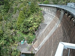
The Upper Nihotupu Reservoir is one of five reservoirs in the Waitākere Ranges that supply water to Auckland, New Zealand. Completed in 1923, the concrete gravity dam and its reservoir are managed by Watercare Services, a council-owned company.

Te Tātua a Riukiuta / Big King is a volcano and Tūpuna Maunga in Three Kings, New Zealand that erupted 28,500 years ago. The volcano had three prominent peaks known as Three Kings and a number of smaller peaks until most of them were quarried away, leaving a sole remaining large peak known as Big King.

West Auckland is one of the major geographical regions of Auckland, the largest city in New Zealand. Much of the region is dominated by the Waitākere Ranges, the eastern slopes of the Miocene era Waitākere volcano which was upraised from the ocean floor, and the largest regional park in New Zealand. The metropolitan area of West Auckland developed on the lands between the Waitākere Ranges to the west and the upper reaches of the Waitematā Harbour to the east, centred around suburbs such as Massey, Henderson, New Lynn and Glen Eden.

The Big Muddy Creek is an estuarine tidal inlet of the Auckland Region of New Zealand's North Island. It flows south from its tributary rivers, the Nihotupu Stream and the Island stream in the Waitākere Ranges which are dammed at the Lower Nihotupu Reservoir, towards the Manukau Harbour.
Little Huia is a western coastal settlement of West Auckland, Auckland, New Zealand and forms part of the Waitākere Ranges Regional Park, bordering the Manukau Harbour. It is located south-west of the settlement of Huia.
Ngā Oho, also known as Ngā Ohomatakamokamo-o-Ohomairangi, is the name of a historical iwi (tribe) of Māori who settled in the Auckland Region. In the 17th century, Ngā Oho and two other tribes of shared heritage, Ngā Riki and Ngā Iwi, formed the Waiohua confederation of tribes.

The Kakamatua Inlet is an inlet of the Manukau Harbour of the Auckland Region of New Zealand's North Island.