Mount Adams, known by some Native American tribes as Pahto or Klickitat, is a potentially active stratovolcano in the Cascade Range. Although Adams has not erupted in more than 1,000 years, it is not considered extinct. It is the second-highest mountain in Washington, after Mount Rainier.

Pinnacle Peak is a 6,562 ft peak located in Mount Rainier National Park in Lewis County, Washington. It is the second highest peak in the Tatoosh Range. There are two other Washington summits with the same name: Pinnacle Peak near Enumclaw, Washington, roughly 30 miles (50 km) to the northwest, and Pinnacle Peak in North Cascades State Park.
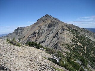
Eagle Peak is a 5,958-foot (1,816-metre) mountain summit in Lewis County of Washington state. It is set on the west end of the Tatoosh Range which is a sub-range of the Cascade Range. It is located south of Mount Rainier, within Mount Rainier National Park, and immediately east of Longmire. Eagle Peak was originally known as Simlayshe, a Native American word meaning eagle. George Longmire anglicized the name to Eagle Peak. The four-mile Eagle Peak Trail leads to views of Mount Rainier. The summit of Eagle Peak requires scrambling. Precipitation runoff on the peak drains into the Nisqually River.

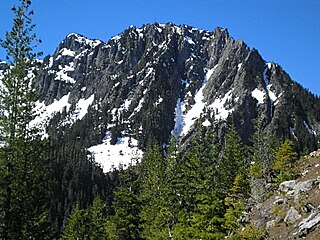
Antler Peak is a 7,017-foot (2,139-metre) summit located in Mount Rainier National Park in Pierce County of Washington state. It is part of the Sourdough Mountains, a subset of the Cascade Range. Antler Peak is situated west of Dege Peak and northeast of Sunrise Historic District, with the Sourdough Ridge Trail traversing the south slope of Antler between the two. Mount Fremont is the nearest higher peak, 1.55 mi (2.49 km) to the west. Precipitation runoff from Antler Peak drains into the White River.

Mount Fremont is a 7,214-foot-elevation mountain summit located in Mount Rainier National Park in Pierce County of Washington state. Mount Fremont is a minor peak at the southwest corner of the Sourdough Mountains which are a subset of the Cascade Range. It also the juncture for a small ridge of peaks of similar size running to the northeast. Mount Fremont is situated northwest of the Sunrise Historic District, with a popular trail leading to the Mount Fremont Fire Lookout. However, this trail does not reach the true summit which is 0.25 mi (0.40 km) north of Frozen Lake. Peak 7317, also known as Mount Fremont North, located 0.31 mi (0.50 km) west-northwest along the ridge is its nearest higher neighbor. Access is limited by snowpack closing the Sunrise Road much of the year. July, August, and September are typically the months when the Sunrise Road is seasonally open for vehicle traffic. Precipitation runoff from Mount Fremont drains into the White River.

Shriner Peak is a 5,834-foot-elevation mountain summit located in Mount Rainier National Park in Pierce County of Washington state. It is part of the Cascade Range and is situated south of Cayuse Pass, southwest of Seymour Peak, and southeast of Double Peak. A four mile trail leads from Highway 123 to the Shriner Peak Fire Lookout at the top of the mountain. Precipitation runoff from Shriner Peak drains into tributaries of the Cowlitz River.

Deadwood Peak is a 6,280-foot-elevation mountain summit located on the eastern border of Mount Rainier National Park. It is also situated on the shared border of Pierce County and Yakima County in Washington state. Deadwood Peak is set on the crest of the Cascade Range, immediately north of Yakima Peak and Chinook Pass, with the Pacific Crest Trail traversing its east slope. Its nearest higher peak is Naches Peak, 0.59 mi (0.95 km) to the southeast. Deadwood Peak takes its name from Deadwood Lakes and Deadwood Creek to its northwest, and their names came from the large number of downed trees in the area. From Chinook Pass, a short scramble up the south side leads to the summit with unobstructed views of Mount Rainier.

Tamanos Mountain is a 6,790-foot (2,070 m) summit located in Mount Rainier National Park in Pierce County of Washington state. It is part of the Cascade Range. Tamanos Mountain is situated west of Governors Ridge and northeast of the Cowlitz Chimneys, all of which can be seen from the Sunrise Historic District. The name tamanos derives from Chinook Jargon and has the meaning of guardian spirit. This landform's toponym was officially adopted by the U.S. Board on Geographic Names in 1932. Topographic relief is significant as the summit rises 3,100 feet above the White River in approximately 1.5 mile. The normal climbing access is from the Owyhigh Lakes Trail, and from the lakes scrambling up the south slope to the summit.
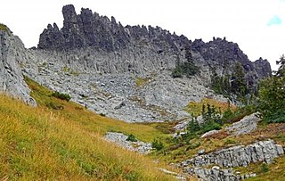
The Castle is a summit in Lewis County of Washington state. It is part of the Tatoosh Range which is a sub-range of the Cascade Range. The Castle is located in Mount Rainier National Park, and it is 0.2 mile immediately east of Pinnacle Peak. Precipitation runoff from The Castle drains into tributaries of the Cowlitz River.

Barrier Peak is a small 6,521-foot (1,988-metre) summit located in Mount Rainier National Park in Pierce County of Washington state. It is part of the Cascade Range and is situated west of Cayuse Pass, 0.53 mile west-northwest of Buell Peak, and 0.4 mile south-southwest of Governors Ridge, which is its nearest higher peak. Precipitation runoff from Barrier Peak drains into tributaries of the White River and Cowlitz River. The normal climbing access is from the Owyhigh Lakes Trail. The peak was so named because it served as a barrier between the Cayuse Pass region and the rest of Mount Rainier National Park.

Denman Peak is a small 6,006 ft summit in the Tatoosh Range which is a sub-range of the Cascade Range. It's located south of Mount Rainier within Mount Rainier National Park. Denman Peak is situated east of Lane Peak and west of Pinnacle Peak.
Mount Aix is a 7,766-foot (2,367 m) mountain summit in Yakima County of Washington state.
Hidden Lake Peaks is series of peaks with a maximum elevation of 7,088 feet that are located in the North Cascades, in Skagit County of Washington state. The peaks extend three miles southwest from the nearest higher peak called The Triad. Situated on the western boundary of North Cascades National Park, Hidden Lake Peaks are positioned west of the crest of the Cascade Range, approximately ten miles east of the town of Marblemount. The popular subsidiary peak, Hidden Lake Lookout (6890 ft), lies a half mile to the southwest of the highest summit. The mountain's name is taken from its proximity to Hidden Lake which lies in a cirque below the east aspect of these two main peaks. Precipitation runoff from Hidden Lake Peaks drains into Cascade River which is a tributary of the Skagit River.

Crystal Peak is a 6,595-foot summit located in eastern Mount Rainier National Park, in Pierce County of Washington state. Crystal Peak is situated 0.75 mi (1.21 km) northwest of Chinook Peak, and nearly on the crest of the Cascade Range. Crystal Mountain and Crystal Lakes lie immediately to the northeast, and Three Way Peak is 1.09 mi (1.75 km) to the east. Access to the summit is via a hiking trail which branches off from the Crystal Lakes Trail. That trailhead starts along Highway 410, which traverses the western base of the mountain. Precipitation runoff from Crystal Peak drains into tributaries of the White River.

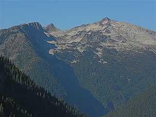
Old Desolate is a 7,137-foot (2,175 m) multi-summit, ridge-like mountain located in Mount Rainier National Park, in Pierce County of Washington state. It is part of the Cascade Range, and lies five miles (8.0 km) due north of the summit of Mount Rainier. The Wonderland Trail provides an approach to this mountain, and the summit offers views of Sluiskin Mountain and Mount Rainier. Burroughs Mountain is the nearest higher neighbor, 2.37 mi (3.81 km) to the southeast. Precipitation runoff from Old Desolate drains east into the West Fork White River, or west into the Carbon River.
Mother Mountain is a 6,480+ ft multi-summit, 3-mile long ridge-like mountain located in Mount Rainier National Park, in Pierce County of Washington state. It is part of the Cascade Range, and lies 7 mi (11 km) northwest of the summit of Mount Rainier. The Wonderland Trail provides one approach option to this mountain, and the summit offers views of Mount Rainier. East Fay Peak is its nearest higher neighbor, 0.42 mi (0.68 km) to the south. Precipitation runoff from Mother Mountain is drained by Cataract Creek on the south side of the mountain, and Ipsut Creek drains the north side of it, and both are tributaries of the Carbon River. The west side drains into Mowich Lake, and thence Mowich River.

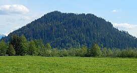
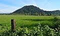
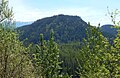
Tumtum Peak is a 4,678-foot-elevation (1,426-meter) mountain summit located in the southwest corner of Mount Rainier National Park, in Pierce County of Washington state. This top-to-bottom forested peak is part of the Cascade Range and lies 8.7 mi (14.0 km) southwest of the summit of Mount Rainier. The nearest higher neighbor is Mount Wow, 2.2 mi (3.5 km) to the northwest, and Iron Mountain rises 3.56 mi (5.73 km) to the northeast. Precipitation runoff from Tumtum Peak is drained by Tahoma Creek on the west side of the mountain, whereas Kautz Creek drains the east side, and both are tributaries of the Nisqually River. The Road to Paradise traverses the southern base of the peak shortly after visitors to the park enter via the Nisqually Entrance. Topographic relief is significant as the southwest aspect rises nearly 2,500 feet above the road in one mile.

Kelly Butte is a 5,417-foot-elevation (1,651-meter) summit located in the southeast corner of King County in Washington state. It is set on land managed by Mount Baker-Snoqualmie National Forest. It is situated 3.1 mi (5.0 km) northwest of Colquhoun Peak and five miles west of the crest of the Cascade Range. Precipitation runoff from Kelly Butte drains into tributaries of the Green River. Topographic relief is significant as the west aspect rises 3,000 feet above Rock Creek in one mile. Access is via the 1.7-mile Kelly Butte Trail which leads to a restored, historical fire lookout tower originally constructed in 1926 and occupies the summit. Flora along the trail includes lilies, bear grass, Indian paintbrush, penstemon, arnica, columbine, lupine, phlox, and huckleberry. This geographical feature's name has been officially adopted by the U.S. Board on Geographic Names.

Tinkham Peak is a double summit mountain located on the common boundary of King County and Kittitas County in Washington state.
Mount Crowder is a remote 7,082-foot (2,159-metre) mountain summit in the Picket Range of the North Cascades, in Whatcom County of Washington state. Mount Crowder is situated in North Cascades National Park and Stephen Mather Wilderness. Neighbors include Mount Fury, 1.64 mi (2.64 km) to the northeast, and Twin Needles is set 2.3 mi (3.7 km) to the southeast. Precipitation runoff from this peak drains south into headwaters of Goodell Creek, and northwest into Picket Creek which is a tributary of the Baker River. Topographic relief is significant as the summit rises 4,300 feet above Goodell Creek in approximately one mile.