
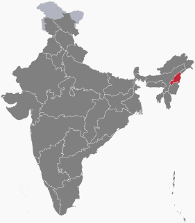
Nagaland is a state in north-eastern India. It is bordered by the state of Arunachal Pradesh to the north, Assam to the west, Manipur to the south and the Sagaing Region of Myanmar to the east. Nagaland's capital city is Kohima and its largest city is Dimapur. It has an area of 16,579 square kilometres (6,401 sq mi) with a population of 1,980,602 per the 2011 Census of India, making it one of the smallest states of India.

Zünheboto (Pron:/ˌzʌnˈhiːbəʊtəʊ/), also known as Zünhebo, is a town in the state of Nagaland, India. Zünheboto is inhabited by the Sümi Nagas. It is the location of the largest Baptist church in Asia, the Sümi Baptist Church, Zünheboto.
The Naga Hills, reaching a height of around 3,825 metres (12,549 ft), lie on the border of India and Burma (Myanmar). They are part of a complex mountain system, and the parts of the mountain ranges inside the Indian state of Nagaland and the Burmese Naga Self-Administered Zone are called the Naga Hills. The highest point of the Naga hills is Mount Saramati.

Tuensang District (Pron:/ˌtjuːənˈsæŋ/) is the largest district in Nagaland, a state in North-East India. Its headquarters is in Tuensang town.

Zünheboto (Pron:/ˌzʌnˈhiːbəʊtəʊ/) is a district of Nagaland state in India.

Tuensang (Pron:/ˌtjuːənˈsæŋ/) is a town and the headquarters of its Tuensang district in Nagaland, India with a population of 36,774.
The Sangtams are one of the major Naga tribe living in the Tuensang and Kiphire districts of Nagaland.

Kiphire (Pron:/ˈkɪfɑɪə/) is a small town, situated at an elevation of 896 m (2,940 ft) above sea level and is the headquarters of the newly formed Kiphire district, carved out of Tuensang district, in Nagaland, India. Kiphire is about 254 km from Kohima, the capital of Nagaland. It is the place where the Naga tribes of Sangtam (Eastern), Yimchunger and Sema tribes meet. The town is the nearest district headquarters to Mt. Saramati, Nagaland's highest peak.

Kiphire (Pron:/ˈkɪfɑɪə/) is the newly formed ninth district of Nagaland which was carved out of Tuensang district. As of 2011 it is the second least populous district of Nagaland, after Longleng.
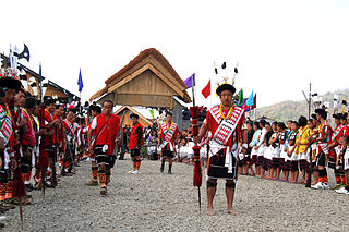
The 'Sümi Naga' is one of the major ethnic group in Nagaland, India. The Sümis mainly inhabit Zünheboto District, Dimapur District and Kiphire District although many have spread and are now living in a few more districts within Nagaland.
Sangtam, also called Thukumi, Isachanure, or Lophomi, is a Naga language spoken in northeast India. It is spoken in Kiphire District and in the Longkhim-Chare circle in Tuensang district, Nagaland, India.
Yimchunger is a Naga tribe whose traditional territory includes Tuensang and Kiphire districts in Nagaland state of India, and western areas of Burma.

Saramati is a peak rising above the surrounding peaks at the mountainous border of Nagaland state, India and the Naga Self-Administered Zone, Burma. It is located near Thanamir Village in the Kiphire district of Nagaland.
The following outline is provided as an overview of and topical guide to Nagaland:
Anatongre is a village in Kiphire district of Nagaland state of India.
Phelungre is a village in Kiphire district of Nagaland state of India.
Chomi is a settlement in Kiphire district of Nagaland state of India.
Zaonger is a settlement in Kiphire district of Nagaland state of India.
Seyochung is a settlement in Kiphire district of Nagaland state of India.
