
Tirumala is a spiritual town in Tirupati district of the Indian state of Andhra Pradesh. It is one of the suburbs of the Tirupati urban agglomeration. The town is a part of Tirupati Urban Development Authority and located in Tirupati (urban) mandal of Tirupati revenue division. It is a hill town where Tirumala Venkateshvara Temple is located, a popular shrine of Vishnu. The town is strictly vegetarian.

The Eastern Ghats are a discontinuous range of mountains along India's eastern coast. The Eastern Ghats pass through the states of Odisha and Andhra Pradesh in the north to Tamil Nadu in the south, passing parts of Karnataka and Telangana on the way. They are eroded and cut through by four major rivers of peninsular India, viz., the Mahanadi, Godavari, Krishna and Kaveri. Jindhagada, or Seethamma Konda, is the highest point in both Andhra Pradesh and the Eastern Ghats, at 1,690 metres (5,540 ft). The Biligiriranga Hills in Karnataka are the tallest hill range in the Eastern Ghats, with many peaks above 1500 m in height.

The Aravalli Range is a mountain range in Northern-Western India, running approximately 670 km (420 mi) in a south-west direction, starting near Delhi, passing through southern Haryana, Rajasthan, and ending in Ahmedabad Gujarat. The highest peak is Guru Shikhar on Mount Abu at 1,722 m (5,650 ft). The Aravalli Range is arguably the oldest geological feature on Earth, having its origin in the Proterozoic era.

The geology of India is diverse. Different regions of India contain rocks belonging to different geologic periods, dating as far back as the Eoarchean Era. Some of the rocks are very deformed and altered. Other deposits include recently deposited alluvium that has yet to undergo diagenesis. Mineral deposits of great variety are found in the Indian subcontinent in huge quantities. Even India's fossil record is impressive in which stromatolites, invertebrates, vertebrates and plant fossils are included. India's geographical land area can be classified into the Deccan Traps, Gondwana and Vindhyan.

Tirupati is a city in the Indian state of Andhra Pradesh. It is the administrative headquarters of the Tirupati district. The city is home to the important Hindu shrine of Tirumala Venkateshwara Temple and other historic temples. It is located at a distance of 150 km from Chennai, 250 km from Bangalore,406 km from Amaravati. It is one of the eight Svayam vyakta kshetras dedicated to Vishnu. Tirupati is a municipal corporation and the headquarters of Tirupati (urban) mandal, Tirupati (rural) mandal, and the Tirupati revenue division.

The Yilgarn Craton is a large craton that constitutes the bulk of the Western Australian land mass. It is bounded by a mixture of sedimentary basins and Proterozoic fold and thrust belts. Zircon grains in the Jack Hills, Narryer Terrane have been dated at ~4.27 Ga, with one detrital zircon dated as old as 4.4 Ga.

Natural Arch, Tirumala hills, a notified National Geo-heritage Monument, is a distinctive geological feature 1 km (0.6 mi) north of the Tirumala hills temple, near the Chakra Teertham in Tirupati district in the state of Andhra Pradesh, India. The arch is also called Silathoranam (శిలాతోరణం) in the local language. The arch measures 8 m (26.2 ft) in width and 3 m (9.8 ft) in height, and is naturally formed in the quartzites of Cuddapah Supergroup of Middle to Upper Proterozoic due to natural erosive forces.
Peninsular Gneiss or Peninsular Gniessic Complex are the gneissic complex of the metamorphics found all over the Indian Peninsula, on top of which, the supra-crustal Dharwar System have been laid down. The term was first fashioned by W.F.Smeeth of the Mysore Geological Department in 1916 based on the first scientific study of this rock exposure. One of the best exposures of this rock mass, dated 2.5 to 3.4 billion years, is located at Lal Bagh in Bangalore. The exposure is also called the Lalbagh rock.
The Cardenas Basalt, also known as either the Cardenas Lava or Cardenas Lavas, is a rock formation that outcrops over an area of about 310 km2 (120 mi2) in the eastern Grand Canyon, Coconino County, Arizona. The lower part of the Cardenas Basalt forms granular talus slopes. Its upper part forms nearly continuous low cliffs that are parallel to the general course of the Colorado River. The most complete, readily accessible, and easily studied exposure of the Cardenas Basalt lies in Basalt Canyon. This is also its type locality.

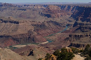
The Unkar Group is a sequence of strata of Proterozoic age that are subdivided into five geologic formations and exposed within the Grand Canyon, Arizona, Southwestern United States. The 5-unit Unkar Group is the basal member of the 8-member Grand Canyon Supergroup. The Unkar is about 1,600 to 2,200 m thick and composed, in ascending order, of the Bass Formation, Hakatai Shale, Shinumo Quartzite, Dox Formation, and Cardenas Basalt. Units 4 & 5 are found mostly in the eastern region of Grand Canyon. Units 1 through 3 are found in central Grand Canyon. The Unkar Group accumulated approximately between 1250 and 1104 Ma. In ascending order, the Unkar Group is overlain by the Nankoweap Formation, about 113 to 150 m thick; the Chuar Group, about 1,900 m (6,200 ft) thick; and the Sixtymile Formation, about 60 m (200 ft) thick. These are all of the units of the Grand Canyon Supergroup. The Unkar Group makes up approximately half of the thickness of the 8-unit Supergroup.

The Bass Formation, also known as the Bass Limestone, is a Mesoproterozoic rock formation that outcrops in the eastern Grand Canyon, Coconino County, Arizona. The Bass Formation erodes as either cliffs or stair-stepped cliffs. In the case of the stair-stepped topography, resistant dolomite layers form risers and argillite layers form steep treads. In general, the Bass Formation in the Grand Canyon region and associated strata of the Unkar Group-rocks dip northeast (10°–30°) toward normal faults that dip 60+° toward the southwest. This can be seen at the Palisades fault in the eastern part of the main Unkar Group outcrop area. In addition, thick, prominent, and dark-colored basaltic sills intrude across the Bass Formation.

The Shinumo Quartzite also known as the Shinumo Sandstone, is a Mesoproterozoic rock formation, which outcrops in the eastern Grand Canyon, Coconino County, Arizona,. It is the 3rd member of the 5-unit Unkar Group. The Shinumo Quartzite consists of a series of massive, cliff-forming sandstones and sedimentary quartzites. Its cliffs contrast sharply with the stair-stepped topography of typically brightly-colored strata of the underlying slope-forming Hakatai Shale. Overlying the Shinumo, dark green to black, fissile, slope-forming shales of the Dox Formation create a well-defined notch. It and other formations of the Unkar Group occur as isolated fault-bound remnants along the main stem of the Colorado River and its tributaries in Grand Canyon.
Typically, the Shinumo Quartzite and associated strata of the Unkar Group dip northeast (10°–30°) toward normal faults that dip 60+° toward the southwest. This can be seen at the Palisades fault in the eastern part of the main Unkar Group outcrop area.

The geology of the Isle of Skye in Scotland is highly varied and the island's landscape reflects changes in the underlying nature of the rocks. A wide range of rock types are exposed on the island, sedimentary, metamorphic and igneous, ranging in age from the Archaean through to the Quaternary.

The Vishnu Basement Rocks is the name recommended for all Early Proterozoic crystalline rocks exposed in the Grand Canyon region. They form the crystalline basement rocks that underlie the Bass Limestone of the Unkar Group of the Grand Canyon Supergroup and the Tapeats Sandstone of the Tonto Group. These basement rocks have also been called either the Vishnu Complex or Vishnu Metamorphic Complex. These Early Proterozoic crystalline rocks consist of metamorphic rocks that are collectively known as the Granite Gorge Metamorphic Suite; sections of the Vishnu Basement Rocks contain Early Paleoproterozoic granite, granitic pegmatite, aplite, and granodiorite that have intruded these metamorphic rocks, and also, intrusive Early Paleoproterozoic ultramafic rocks.

The Aravalli Mountain Range is a northeast-southwest trending orogenic belt in the northwest part of India and is part of the Indian Shield that was formed from a series of cratonic collisions. The Aravalli Mountains consist of the Aravalli and Delhi fold belts, and are collectively known as the Aravalli-Delhi orogenic belt. The whole mountain range is about 700 km long. Unlike the much younger Himalayan section nearby, the Aravalli Mountains are believed much older and can be traced back to the Proterozoic Eon. They are arguably the oldest geological feature on Earth. The collision between the Bundelkhand craton and the Marwar craton is believed to be the primary mechanism for the development of the mountain range.

The geology of Tanzania began to form in the Precambrian, in the Archean and Proterozoic eons, in some cases more than 2.5 billion years ago. Igneous and metamorphic crystalline basement rock forms the Archean Tanzania Craton, which is surrounded by the Proterozoic Ubendian belt, Mozambique Belt and Karagwe-Ankole Belt. The region experienced downwarping of the crust during the Paleozoic and Mesozoic, as the massive Karoo Supergroup deposited. Within the past 100 million years, Tanzania has experienced marine sedimentary rock deposition along the coast and rift formation inland, which has produced large rift lakes. Tanzania has extensive, but poorly explored and exploited natural resources, including coal, gold, diamonds, graphite and clays.

The geological history of Zambia begins in the Proterozoic eon of the Precambrian. The igneous and metamorphic basement rocks tend to be highly metamorphosed and may have formed earlier in the Archean, but heat and pressure has destroyed evidence of earlier conditions. Major sedimentary and metamorphic groups formed in the mid-Proterozoic, followed by a series of glaciations in the Neoproterozoic and much of the Paleozoic which deposited glacial conglomerate as well as other sediments to form the Katanga Supergroup and rift-related Karoo Supergroup. Basalt eruptions blanketed the Karoo Supergroup in the Mesozoic and Zambia shifted to coal and sandstone formation. Geologically recent windblown sands from the Kalahari Desert and alluvial deposits near rivers play an important role in the modern surficial geology of Zambia. The country has extensive natural resources, particularly copper, but also cobalt, emeralds, other gemstones, uranium and coal.
The geology of Eswatini formed beginning 3.6 billion years ago, in the Archean Eon of the Precambrian. Eswatini is the only country entirely underlain by the Kaapvaal Craton, one of the oldest pieces of stable continental crust and the only craton regarded as "pristine" by geologists, other than the Yilgarn Craton in Australia. As such, the country has very ancient granite, gneiss and in some cases sedimentary rocks from the Archean into the Proterozoic, overlain by sedimentary rocks and igneous rocks formed during the last 539 million years of the Phanerozoic as part of the Karoo Supergroup. Intensive weathering has created thick zones of saprolite and heavily weathered soils.
The geology of Wisconsin includes Precambrian crystalline basement rock over three billion years old. A widespread marine environment during the Paleozoic flooded the region, depositing sedimentary rocks which cover most of the center and south of the state.

The geology of Kazakhstan includes extensive basement rocks from the Precambrian and widespread Paleozoic rocks, as well as sediments formed in rift basins during the Mesozoic.


