Unakoti district

Last updated

Unakoti
Unakoti 3.jpg
Unakoti hill
Unokoti in Tripura (India).svg
Location in Tripura
State Tripura
Country India
Formation21 January 2012;12 years ago (2012-01-21)
District headquarters Kailasahar
Government
   Collector & District Magistrate Tarit Kanti Chakma, IAS
Area
  Total686.97 km2 (265.24 sq mi)
Elevation
915 m (3,002 ft)
Population
 (2011)
  Total298,574
  Density430/km2 (1,100/sq mi)
Time zone UTC+05:30 (IST)
PIN
7992XX
STD3822
ISO 3166 code IN-TR
Website http://unakoti.nic.in/

Unakoti is an administrative district in the state of Tripura in northeastern India. It is the least populated district of Tripura, with fourth highest literacy rate. The district has a total of four sub divisions and two blocks. The district was created in 2012, by bifurcating the North Tripura district with its headquarter in Kailashahar. [1]

Contents

History

The former princely state of Tripura was ruled by Maharajas of Manikya dynasty. It was an independent administrative unit under the Maharaja even during the British rule in India, though this independence was qualified, being subject to the recognition of the British, as the paramount power of each successive ruler.

As per Rajmala, the royal chronology of Tripura, a total of 184 kings ruled over the state before it merged with the Indian Union on 15 October 1949. Since then the history of Tripura has been interspersed with various political, economical and social developments. On 26 January 1950 Tripura was accorded the status of a ‘C’ category state and on 1 November 1956, it was recognized as a Union Territory. It gained full statehood on 21 January 1972, as per the North-East Reorganisation Act, 1971.

Initially a one district state, was trifurcated into three Districts w.e.f. 01.09.1970. The North Tripura District started functioning in the office of the Sub-divisional officer at Kailashahar and partly at Kumarghat, later the whole office was shifted to Kailashahar. The Collectorate was shifted to the newly constructed complex at Gournagar on 13.11.1987.

Subsequently, North Tripura District has been bifurcated and a new District namely "Dhalai District" has been inaugurated on 14.04.1995 with district head quarter at Ambassa.

On 21.01.2012 the decision to further bifurcate North Tripura District was accepted and the district "UNAKOTI DISTRICT" was created with its headquarter at Kailashahar. [1]

Etymology

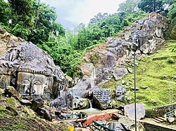
Unakoti derives its name from the Unakoti hill. Unakoti literally meaning, one less a koti in Bengali. It hosts an ancient Shaivite place of worship with huge rock reliefs celebrating Shiva. [2]

Geography

The district is surrounded by Dharmanagar subdivision, Panisagar subdivision and Kanchanpur subdivision of North Tripura district in the Northeast, East and Southeast side respectively. In the southern side, it is surrounded by Kamalpur subdivision and Longthari valley subdivision of Dhalai district. It also shares an international border with Bangladesh in the northern side.

Divisions

The District and divided into two sub-divisions, namely, Kailashahar subdivision and Kumarghat subdivision.

For the purpose of developmental activities it is divided into four Blocks namely Kumarghat, Pecharthal, Chandipur and Gournagar. [3]

Demographics

According to census 2011 Unakoti district has Total population of 2,76,506. Out of this Male are 1,40,210 and, Female are1,36,296, Overall literacy rate (%) is 86.91. Male literacy rate (%) is 90.92, Female literacy rate (%) is 82.79, Female per thousand males are 972. [4]

Climate

The state as whole and Unakoti district in particular has a monsoon type of climate. There is however, difference of temperature between the hills and plains, which ranges between sub-tropical in the plains to temperate climatic conditions found in the hilly areas.

The topographic features seem to have influenced the climatic condition of the Unakoti district, where the plains are hotter and humid in comparison to the hills, which have a salubrious climate. The four main seasons here are

  1. Winter season (December to February)
  2. Pre-monsoon season (March to May)
  3. Monsoon season (June to September)
  4. Post Monsoon season (October to November)

The climatic temperature generally ranges in between 10°C and 35°C. The District enjoys coldest season from December to February followed by summer during the months from March to May. The highest temperature is generally recorded in the month of May and the lowest in January. The SouthWest monsoon reaches the State in the months from June to September. Rainy season generally starts by about the end of May but thundershowers usually occur from about April to the break of the monsoon. The rainy season continues up to September. The maximum rainfall is usually recorded during the month of June – July. The months of October and November constitute the post monsoon season. [5]

Transport

Roadway

National Highway 8 (NH 8), running from Karimganj in Assam to Sabroom in Tripura, passes through this district. [6]

Railway

Lumding–Sabroom line of Northeast Frontier Railway passes through Unakoti district. The main station in district is Kumarghat railway station, providing connectivity to Tripura capital Agartala and Assam and other major cities of the state like Dharmanagar, Udaipur and Belonia. [7]

Villages

Related Research Articles

<span class="mw-page-title-main">Tripura</span> State in northeastern India

Tripura is a state in Northeast India. The third-smallest state in the country, it covers 10,491 km2 (4,051 sq mi); and the seventh-least populous state with a population of 3.67 million. It is bordered by Assam and Mizoram to the east and by Bangladesh to the north, south and west. Tripura is divided into 8 districts and 23 sub-divisions, where Agartala is the capital and the largest city in the state. Tripura has 19 different tribal communities with a majority Bengali population. Bengali, English and Kokborok are the state's official languages.

<span class="mw-page-title-main">Dhalai district</span> District of Tripura in India

Dhalai is an administrative district in the state of Tripura in India. The district headquarter is in Ambassa. As of 2011 it was the least populous district of Tripura, although it is the largest district in the state.

<span class="mw-page-title-main">North Tripura district</span> District in Tripura, India

North Tripura is an administrative district in the state of Tripura in India. The district headquarters are located at Dharmanagar. The district occupies an area of 1422.19 km² and has a population of 693,947.

<span class="mw-page-title-main">West Tripura district</span> District in India India, Tripura

West Tripura is an administrative district in the state of Tripura in India. The district headquarters are located at Agartala. As of 2012 it is the most populous district of Tripura.

Belonia is a town and municipal council in South Tripura district, Tripura, India. It is also the headquarters of South Tripura District. It is linked with Agartala by National Highway 108A from Belonia to Jolaibari and via National Highway 8 from Jolaibari to Agartala. Belonia lies on the border with Bangladesh.

<span class="mw-page-title-main">Dharmanagar</span> Town in Tripura, India

Dharmanagar or (Dhôrmônôgôr) is a town with a municipal council in the northeast of India. It is the administrative center for North Tripura district, located in the northernmost region of the state near the Assam border on the west and the India-Bangladesh border on the east. It is the second largest urban area in the state, which make it one of the important commercial centre. The Juri river flows through the town.

Kamalpur is a town and a Nagar Panchayat in Dhalai District in the Indian state of Tripura around 93 km from the state capital Agartala. It is the largest Sub-divisional town in Dhalai District.

Kumarghat is a town and subdivision in Unakoti district in Tripura, India. It is a municipal council and the 14th largest town in Tripura by population. Kumarghat railway station is the only railway station in Unakoti district.

<span class="mw-page-title-main">Tripura Police</span> State police force of Tripura, India

Tripura Police is the law enforcement agency of the state of Tripura which organizes and is responsible for policing activities in the state of Tripura, Northeast India. It was formed in the year 1965. Currently Shri Amitabh Ranjan, IPS is DGP of Tripura.

<span class="mw-page-title-main">Unakoti</span> Heritage site in Tripura, India

Unakoti famously known as Angkor Wat of the North-East, is a sculptural emblem and ancient Shaivite place that hosts rock carvings, figures and images of gods and goddesses. It is a place of worship with huge rock reliefs celebrating Shiva. Unakoti literally means "one less than one crore" or "koti" in Hindi. In the local Kokborok language, it is called Subrai Khung. It was put on the UNESCO world heritage site tentative list in 2022. It is the prime tourist spot of Unakoti District, in the Kailashahar Subdivision of the North-eastern Indian state of Tripura.

Kailashahar is the fourth largest urban area in the north eastern state of India, Tripura, located near northwest Bangladesh border. It is a Municipal council and the administrative center of the Unakoti district, this city is surrounded by unakoti hills and flows through Tripura's longest river, Manu.

<span class="mw-page-title-main">Lumding–Sabroom section</span>

The Lumding–Sabroom section is a railway line under Lumding railway division of Northeast Frontier Railway zone of Indian Railways. It is a single 1,676 mm broad-gauge track from Lumding in Nagaon District of Assam state to Agartala in West Tripura district of Tripura state. The 43 km-long 1,676 mm segment from Agartala southwards to Udaipur, Tripura was completed in 2016 and became operational on 23 January 2017. The remaining 70 km long track to Sabroom at the bank of Feni River at Bangladesh border was completed in 2019 and became operational on 3 October 2019.

Khowai district is a district of Tripura state of India. This district was created in January, 2012 when four new districts were created in Tripura, taking the number of districts in the state from four to eight. The district headquarters are located in the town Khowai. The district was carved out of West Tripura district along with new Sipahijala district. The district is divided into two subdivisions, namely Khowai and Teliamura.

<span class="mw-page-title-main">Agartala railway station</span> Railway Station in Tripura, India

Agartala Railway Station is located 5.5 km (3.4 mi) from Agartala in Tripura, India. It is the second capital city in northeast India to be connected to the country's railway map, moreover Agartala is the first state capital of independent India to be connected with a rail network. Before 2015 the 413-kilometre (257 mi) route was connected to Lumding with a metre-gauge track, but after the gauge conversion to broad gauge in 2016, the track is connected directly to Guwahati and the rest of India.

<span class="mw-page-title-main">Sipahijala district</span> District of Tripura in India

Sipahijala District is a district of Tripura, India. This district was created in January 2012 when four new districts were established in Tripura, taking the number of districts in the state from four to eight. Part of the district was formed from the former district of West Tripura. The principal towns in the district are Bishalgarh, Bishramganj, Melaghar and Sonamura.

<span class="mw-page-title-main">Gomati district</span> District of Tripura in India

Gomati district is a district of Tripura, India. This district was created in January 2012 when four new districts were created in Tripura, taking the number of districts in the state from four to eight. Udaipur is its headquarters.

Darchawi is a village in Kumarghat Subdivision under Unakoti district of Tripura state in India. Mainly inhabited by the Darlong people of Tripura, it is also the headquarters of Kailashahar Baptist Christian Association.

<span class="mw-page-title-main">Outline of Tripura</span> Overview of and topical guide to Tripura

The following outline is provided as an overview of and topical guide to Tripura:

Kanchanbari is a village in the Kumarghat subdistrict of the Unakoti district in the Indian state of Tripura. This village is located 28 kilometres (17 mi) south of the district headquarters in Kailasahar and 91 kilometres (57 mi) from the state capital Agartala. The village had a population of 6,696 as of 2011.

References

  1. 1 2 "History | Unakoti District Website | India" . Retrieved 25 October 2022.
  2. "Feature". Archived from the original on 21 August 2001.
  3. "Unakoti District Map".
  4. "DISTRICT SURVEY REPORT (UNAKOTI DISTRICT, TRIPURA)" (PDF).
  5. "Home | IMD Agartala". agartala.imd.gov.in. Retrieved 25 October 2022.
  6. "Rationalisation of Numbering Systems of National Highways" (PDF). New Delhi: Department of Road Transport and Highways. Archived from the original (PDF) on 4 December 2018. Retrieved 3 April 2012.
  7. "Kumarghat Railway station, Indian Rail Info".

24°14′12″N92°01′12″E / 24.2366°N 92.0199°E / 24.2366; 92.0199