This article needs additional citations for verification .(February 2016) |
Belonia | |
|---|---|
Municipal council | |
 Belonia  Belonia | |
| Coordinates: 23°15′N91°27′E / 23.25°N 91.45°E | |
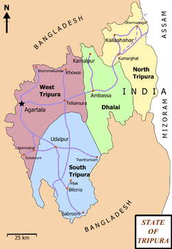
| Country | India |
| State | Tripura |
| District | South Tripura |
| Government | |
| • Type | Municipal Council |
| • Body | Belonia Municipal Council |
| • Chairman | Nikhil Chandra Gope (BJP) |
| Elevation | 23 m (75 ft) |
| Population (2015) | |
• Total | 21,176 |
| Languages | |
| • Official | |
| Time zone | UTC+5:30 (IST) |
| Pin | 799155 |
| Telephone code | 03823 |
| Vehicle registration | TR 08 |
| Website | southtripura |
Belonia is a town and municipal council in South Tripura district, Tripura, India. It is also the headquarters of South Tripura District. It is linked with Agartala (the state capital) by National Highway 108A from Belonia to Jolaibari and via National Highway 8 from Jolaibari to Agartala. Belonia lies on the border with Bangladesh.