Ambassa

Last updated

Ambassa
Āmbāsā (Bengali)
Census town
India Tripura location map.svg
Red pog.svg
Ambassa
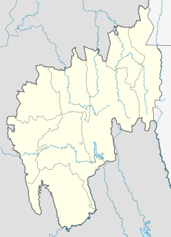
Location in Tripura, India
India location map.svg
Red pog.svg
Ambassa
Ambassa (India)
Coordinates: 23°55′10.8″N91°50′42″E / 23.919667°N 91.84500°E / 23.919667; 91.84500
CountryFlag of India.svg  India
State Tripura
District Dhalai
Government
  Type Municipal Council
  BodyAmbassa Municipal Council
   Chairman Smt. Mamata Das (BJP)
Languages
  Official Bengali, Kokborok, English
Time zone UTC+5:30 (IST)
Vehicle registration TR-04
Website tripura.gov.in

Ambassa is a census town located in the Indian state of Tripura a Municipal Council in Dhalai district. Ambassa is also the headquarters of the Dhalai district.
Contents

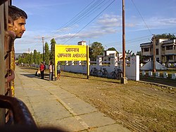
a picture of Ambassa railway station Agartala, Tripura (11).jpeg
a picture of Ambassa railway station

Demographics

As of 2001 India census, [1] Ambassa had a population of 6,052. Males constituted 54% of the population and females 46%. Ambassa had an average literacy rate of 70%, higher than the national average of 59.5%; 60% of males and 40% of females were literate. 13% of the population were under 6 years of age.

See also

Related Research Articles

<span class="mw-page-title-main">Dhalai district</span> District of Tripura in India

Dhalai is an administrative district in the state of Tripura in India. The district headquarter is in Ambassa. As of 2011 it was the least populous district of Tripura, although it is the largest district in the state.

<span class="mw-page-title-main">North Tripura district</span> District in Tripura, India

North Tripura is an administrative district in the state of Tripura in India. The district headquarters are located at Dharmanagar. The district occupies an area of 1422.19 km2 and has a population of 693,947, 856,(as of 2024).

South Tripura is an administrative district in the state of Tripura in northeastern India.

<span class="mw-page-title-main">West Tripura district</span> District in India India, Tripura

West Tripura is an administrative district in the state of Tripura in India. The district headquarters are located at Agartala. As of 2012 it is the most populous district of Tripura.

Badharghat is a census town in West Tripura district in the state of Tripura, India.

<span class="mw-page-title-main">Dharmanagar</span> Town in Tripura, India

Dharmanagar is a town with a municipal council in the northeast of India. It is the administrative center for North Tripura district, located in the northernmost region of the Country near the Bangladesh border on the east and the India-Bangladesh border on the west. It is the second largest urban area in the state, which make it one of the important commercial centre. The Juri river flows through the town.

Gakulnagar is a census town in West Tripura district in the state of Tripura, India.

Indranagar is a census town in West Tripura district in the Indian state of Tripura. The locality is famous for the Kali temple. Everyday many devotees are found to offer worship to the goddess Kali. During Dewali a fair is held for three days. Large gathering is observed. ITI is another landmark of the place.

Kamalpur is a town and a Nagar Panchayat in Dhalai District in the Indian state of Tripura around 93 km from the state capital Agartala. It is the largest Sub-divisional town in Dhalai District.

Kunjaban is a census town in West Tripura district in the Indian state of Tripura.

Ranirbazar is a town and a Municipal Council in West Tripura district in the Indian state of Tripura.

Sabroom is a town and a Nagar Panchayat in South Tripura district in the Indian state of Tripura. It is located on the banks of the Feni River, which separates India and Bangladesh. It is believed that during the Bangladesh War of Independence in 1971, the Hindu society people migrated to Sabroom from Noakhali and Feni districts of Bangladesh.

Teliamura is a town and a Municipal Council in Khowai district in the Indian state of Tripura. It is on National Highway No. 08 of India. It is also the headquarters of the recently included sub-division of Teliamura. It is 45 km from Agartala, Capital of Tripura, 35 km from Khowai and 42 km from Ambassa.

Narsingarh is a census town in West Tripura district in the Indian state of Tripura.

Pratapgarh is a census town in West Tripura district in the Indian state of Tripura.

Khowai district is a district of Tripura state of India. This district was created in January, 2012 when four new districts were created in Tripura, taking the number of districts in the state from four to eight. The district headquarters are located in the town Khowai. The district was carved out of West Tripura district along with new Sipahijala district. The district is divided into two subdivisions, namely Khowai and Teliamura.

<span class="mw-page-title-main">Dhalai River</span> River in Tripura, India and Bangladesh

The Dhalai River is a trans-boundary river in India and Bangladesh. It rises in the mountains of the Indian state of Tripura. It enters Kamalganj Upazila of Maulvibazar District of Bangladesh. Later, it joins the Manu River in Rajnagar Upazila. The co-ordinates of the Dhalai River at Ambassa are 23.55'128'' N and 91.51'204'' E in degrees, minutes and seconds (DMS). It originates from Atharamura Hill and is 117 kilometres (73 mi) long. Some of the popular riverside townships of the Dhalai are the towns of Ambassa, Baralutma and Kamalpur.

<span class="mw-page-title-main">Unakoti district</span> District of Tripura in India

Unakoti is an administrative district in the state of Tripura in northeastern India. It is the least populated district of Tripura, with fourth highest literacy rate. The district has a total of four sub divisions and two blocks. The district was created in 2012, by bifurcating the North Tripura district with its headquarter in Kailashahar.

<span class="mw-page-title-main">Ambassa railway station</span> Railway station in Tripura, India

Ambassa Railway Station is a small railway station in Dhalai district, Tripura. Its code is ABSA. It serves Ambassa city. The station consists of 3 platforms. One express train till 30 September 2014 used to run between Lumding and Agartala daily. The meter gauge track is converted to broad gauge.

A magnitude 5.7 earthquake struck India 20 km (12 mi) east north-east of Ambassa in the state of Tripura on 3 January 2017 with a maximum observed intensity of 6-7 EMS. It struck at 2:39 pm local time, and was centered in an isolated area. The estimated depth was 32.0 km.

References

  1. "Census of India 2001: Data from the 2001 Census, including cities, villages and towns (Provisional)". Census Commission of India. Archived from the original on 16 June 2004. Retrieved 1 November 2008.