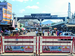
Rajapalayam is a City in the Indian state of Tamil Nadu. It is the largest municipality in the Virudhunagar district. Rajapalayam is located in the Madurai to Quilon National Highway at a distance of 562 km south to the state capital Chennai. Economy is based on textile manufacture: the town has several mills for spinning and weaving cotton, as well as a large cotton market. The town is also famed for Rajapalayam mango and the Rajapalayam breed of dogs.
Ambasamudram is the principal town of the Ambasamudram taluk in Tirunelveli district in the state of Tamil Nadu, India. The entire taluk had a population of 392,226 as of 2001, with 42.5% classified as rural. The town of Ambasamudram had a population 35,645 as of 2011.

Bodinayakanur is a Town and a municipality in Theni district in the state of Tamil Nadu, India.
Edappadi is a municipality in Salem district in the state of Tamil Nadu, India. Edappadi was once known for its thriving power loom industry. The economy is diversified by agriculture, heavy truck transport, granite, entertainment and foundries.
Hesla is a village in Bagodar CD Block in Bagodar-Saria subdivision of Giridih district in the Indian state of Jharkhand.

Hindupur is a city in Sri Sathya Sai district of the Indian state of Andhra Pradesh. It is located to the edge of the Andhra–Karnataka border and is the headquarters of Hindupur mandal. Hindupur is the biggest Parliamentary Constituency in the newly formed District Sri Sathya Sai. It is located about 67 km from district headquarters Puttaparthi, 100 km from Bengaluru the capital of Karnataka, 95 km From Kadiri.
Kalara is a census town in Domjur CD Block of Howrah Sadar subdivision in Howrah district in the Indian state of West Bengal. It is a part of Kolkata Urban Agglomeration.
Katthivakkam is an residential and industrial area located in the northern part of Chennai. It is a part of zone 1 in Greater Chennai Corporation. It is under Thiruvottiyur taluk in Chennai district. It is a part of Thiruvottiyur(state assembly constituency) and Chennai North. Formerly a town and a municipality of Thiruvallur district in the Indian state of Tamil Nadu, it has now been absorbed by Chennai city in September 2011 and within Chennai District limit since January 2018. The neighbourhood is served by Katthivakkam railway station. As of 2011, the town had a population of 36,617.
North Vanlaiphai is a census town in East Lungdar Taluk in the Indian state of Mizoram. In the 2001 census it was listed in Serchhip District; however in the 2011 census it was listed in Champhai District. East Lungdar Taluk is split between the two districts.

Peralasseri is a census town and Panchayat headquarters in Kannur district in the Indian state of Kerala, situated on the Kannur-Kuthuparamba State Highway 38 (Kerala), 12 km from Kannur city, on the bank of Anjarakandy river.
Sadulshahar is a town and a municipality in Sri Ganganagar district in the Indian state of Rajasthan.

Usilampatti is a town and a second grade municipality in the Indian state of Tamil Nadu. It is also a designated taluk and revenue division.
Vickramasingapuram or V.K.Puram is a Municipal town in Tirunelveli District in the Indian state of Tamil Nadu. It falls under the Ambasamudram Taluk. As of 2011, the town had a population of 47,241.
Bishrampur is a census town in Surajpur district in the Indian state of Chhattisgarh.
Maraimalai Nagar is a satellite town of Chennai, Chengalpattu district, Tamil Nadu, India. It is a municipality town in Chengalpattu district. It lies in the southern part of the Chennai metropolitan area around 50 km from downtown Chennai Egmore and about 15 km from Vandalur. It is a satellite town developed by the CMDA in 1980. Many heavy industries are located in Maraimalai Nagar. The Ford India and BMW car factories are located within a mile from Maraimalai Nagar and the Indian software giant Infosys also has an office within eight kilometers of Maraimalai Nagar. SRM University has its main campus in the neighboring Potheri. As of 2011, Maraimalai Nagar had a population of 81,872.
Koodali is a census town and grama panchayat in Thalassery taluk of Kannur district in Kerala state, India. Koodali is located 15.5 km (9.6 mi) east of Kannur city on Kannur-Mattanur road.

Sengottai is a town in the Tenkasi district, of Tamil Nadu, India. It is the gateway to southern Tamil Nadu and Kerala. Spread over an area of 2.68 km2 with a population of over 26,823, the economy of the town revolves around the cultivation of rice.
Joida is a town located in the Uttar Kannada district in the Indian state of Karnataka. The town is the headquarters of the eponymous taluk. Earlier it was known as Supa taluka but as Supa village got submerged due to dam built across river Kali, Joida taluka came into existence. Joida town has a Post office, branch of nationalised banks and a Police station.
Kodamthuruth is a village in Alappuzha district in the Indian state of Kerala. It is a panchayat, which comes under the Aroor Assembly constituency.
Keezhallur is a census town in Kannur district in the Indian state of Kerala.


