Theni District is one of the 38 districts of Tamil Nadu state in India. Theni district is located beside Madurai district. The town of Theni is the district headquarters. The district is divided into two natural divisions: The hilly areas are constituted by parts of the five taluk's Theni, Bodinayakanur, Periyakulam, Uthamapalayam and Andipatti with thick vegetation and perennial streams from the hills on the western side and Cumbum valley which lies in Uthamapalayam taluk. As of 2011, Theni district had a population of 1,245,899 with a sex ratio of 980 females for every 1,000 males.

Batlagundu is a town in Nilakottai block in Dindigul district in the Madurai Region state of Tamil Nadu, India. The name Vetrilaikkundru later transformed and changed to Vathalagundu. The town is the major gateway to Kodaikanal. Subramaniya Siva was a writer, Indian Freedom Fighter, and activist born in Batlagundu. Batlagundu is the fifth-largest town in the Dindigul district. The town is located in such a way connecting three main districts of South Tamil Nadu. Batlagundu has most of the voters in Nilakottai Constituency.
Boothipuram is a panchayat town in Theni district in the state of Tamil Nadu, India.
Chinnamanur is a town and a municipality in Theni district in the state of Tamil Nadu, India. As of 2011, the town had a population of 42,305. The town is one of the major trade centers in the district and supports basic needs for a population of more than 1,00,000 people in and around the town. Chinnamanur in recent times is known for banana marketing. Processed banana from more than twenty units in Chinnamanur are exported to various countries. Chinnamanur also holds the most jewel shops in the entire Theni district. Chinnamanur is the fourth largest town in the district by population and second largest town in the district by area.
Devadanapatti is a panchayat town in Periyakulam Taluk, a part of the Theni district in the Madurai Region in the state of Tamil Nadu, India. It is located at the bottom of the Kodaikanal Hills.
Kamayagoundanpatti is a panchayat town in Theni district in the Indian state of Tamil Nadu.
Cumbum or Kambam, is a town and municipality in Theni district in the western part of the Madurai Region Indian state of Tamil Nadu.
Namagiripettai is a panchayat town in Namakkal district in the Indian state of Tamil Nadu.

Odaipatti is a panchayat town in Theni district in the Tamil Nadu state of India.

Palani Chettipatti is a panchayat town in Theni district in the Indian state of Tamil Nadu. It is located on the road between Theni and Cumbum. The Mullai river flows via this town from Uthamapalayam and goes down the valley.
Pannaipuram is a panchayat town in Theni district in the Indian state of Tamil Nadu. It is located hill foot of "Western Ghats" sharing its border with Kerala State and has very good literacy. Pannaipuram Town panchayat includes 4 villages namely Pannaipuram, Kariyanampatty, Mallingapuram and P. Renganathapuram. Mahalingeswarar Temple, Kaliamman Temple and Bommaiyaswamy Temple are located in Pannaipuram. Veereswarar Temple is located in Kariyanampatty. Most of the people in Pannaipuram are engaged in Cardamom cultivation and trade in nearby Kerala hills.

Periyakulam is a major town and a municipality in Theni district, in the Madurai Region, South Indian state of Tamil Nadu. As of 2011, the town had a population of 42,976. Periyakulam is the northern gateway of the district.
Theni is a town and a municipality in Theni district in the Indian state of Tamil Nadu. As of 2011, the town had a population of 94,453.

Usilampatti is a town and a second grade municipality in the Indian state of Tamil Nadu. It is also a designated taluk and revenue division.
Kombai is a panchayat town in Theni District in the Indian state of Tamil Nadu, located in the beautiful foot hills of Western Ghats, blessed by mother nature with all pancha boota - Land, Water, Fire, Air and Ether. The town is known for its splendid nature, culture, diversity and ethnicity, history, landmarks and flourishing transformation.

Veerapandi is a panchayat gram in Theni district in the Indian state of Tamil Nadu.
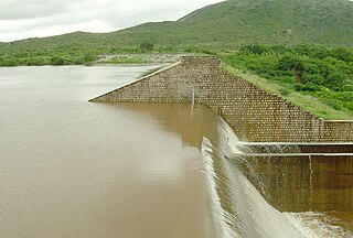
The Shanmuganathi Dam is built across the Shanmugha River near Rayapanpatty, in the Theni district of Tamil Nadu, southern India. It provides water for irrigation for the dry lands such as Pusarikoundan patti, Appipatti, SukkangalPatti, Vellaiammalpuram, Odaipatti and Sepalakottai of Theni district. This dam is more scenery and situated at the foot hill of Meghamalai mountain range just 4 km from Rayapanpatty Village near Uthamapalayam and just 2km from Anaipatty village.
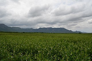
Cumbum Valley, also called Kambam Valley, is a valley in the Theni district of Tamil Nadu state in India near the Kerala state border. This is the most fertile valley in south India, The valley includes lands between Thekkadi Hills, Varusanadu Hills, and Kodaikanal Hills.

Bodimettu is a locality in Theni district in the state of Tamil Nadu in India, near the border with Kerala. It is 10 km from Poopara on the way to Bodinayakkanur by the side of National Highway 85, which runs from Dhanushkkodi to Kochi. Bodimettu is the main cardamom-growing area of Tamil Nadu. It is close to famous tourist destinations such as Munnar, Marayur, Thekkady, Kodaikanal, Anayirangal Dam.
National Highways 183 is located in India. It connects Kollam High school Jn in Kerala with Dindigul in Tamil Nadu. Starting from Kollam it runs northwards and turns east at Kottayam and runs along the northern border of Periyar Wildlife Sanctuary before crossing the border into Tamil Nadu and end near Dindigul, where it joins NH 83(Coimbatore - Nagapattinam). This highway was previously known as NH 220.


