
Igatpuri is a town and a Hill Station. It is also a municipal council in Nashik District in the Indian state of Maharashtra. It is located in the Western Ghats. Igatpuri railway station lies in Nashik District, between Mumbai and Nashik Road on the Central Railway. Igatpuri is known for Vipassana International Academy, where ancient techniques of meditation is taught called Vipassana. The place is one of the best places to visit in Maharashtra in monsoon. It is a hill station on busy Mumbai-Agra NH-3 only 45 km from Nashik and 130 km from Mumbai.
Kadayanallur is a Municipality in Tenkasi district, Tamil Nadu, India. Kadayanallur is approximately 16 km from the town of Tenkasi, the district headquarters. With an area of 52 square kilometres and a population of 90,364, Kadayanallur is classified as a First Grade Municipality under Tamil Nadu's municipal code.

Chikmagalur previously known as Kiriya-Muguli is a city and the headquarters of Chikmagalur district in the Indian state of Karnataka. Located on the foothills of the Mullayanagiri peak of the Western Ghats, the city attracts tourists from around the world for its pleasant and favourable hill station climate, tropical rainforest and coffee estates. The pristine Baba Budangiri lies to the north of Chikmagalur where it's believed Baba Budan first introduced coffee to India.
Pollachi is a town and municipality in Coimbatore district of the Indian state of Tamil Nadu. It is the administrative headquarters of Pollachi taluk. It is situated near the center of the South Indian Peninsula, surrounded by Western Ghats. Agriculture and textile industries contribute majorly to the economy of the town and the town is a popular marketplace for jaggery, vegetables and cattle.
Azhagiapandiapuram is a second grade town panchayat in Kanniyakumari district in the state of Tamil Nadu, India. It is located at the centre of Pazhayar valley. It is one of the four town panchayat's in Thovalai taluk.
Kasara is a census town in Thane district in the Indian state of Maharashtra. The town is on the busy Mumbai–Nashik route, which is one of the four major routes that lead into Mumbai. Kasara is served by a railway station on the Mumbai Suburban Railway, and is the final stop in the north-east sector of the Central Line and important railway station. That is for abbreviation for Kasara Local is set as "N" means North side Local's Last Station. Town is also known for the winding Thal Ghat or better known as Kasara Ghats.

Kothavalasa is a town in Vizianagaram district of the Indian state of Andhra Pradesh. It is located in Kothavalasa mandal of Vizianagaram revenue division. It is located 30 km from the city of Visakhapatanam

Madukkarai is a suburb of Coimbatore city in the Indian state of Tamil Nadu. It is the gateway to Coimbatore city from Kerala State and is located around 12 km from the Kerala border. The Coimbatore International Airport is about 27 km from here. It is the administrative centre for Madukkarai taluk.
Murbad is a census town within the administrative division (taluka) of Thane district in the Indian state of Maharashtra. Murbad city with its neighbouring villages jointly form the Murbad nagar panchayat, which is near the cities of Thane, Karjat and Kalyan. Nearby cities include Badlapur, Ambernath, Ulhasnagar, and Dombivli. It is a largely industrial town with private and public enterprises (MIDC).
Narasimhanaickenpalayam is a part of Coimbatore city. It is about 14 km from Coimbatore city junction in the northern direction. Narasimhanaickenpalayam is on the stretch of National Highway NH 67 Extn (NH-181) Mettupalayam Road, one of the arterial roads of Coimbatore city. Neighbouring places are Thudiyalur, NGGO Colony, and Periyanaickenpalayam
Polur is a scenic town and a Religious site for Lord Narasimha called Sampathgiri, divisional headquarters and a market center in Tiruvannamalai district of Tamil Nadu in India. Located at the foothills of Javvadhi hills, a popular section of Eastern Ghats, Polur is often regarded as Gateway of Eastern ghats. Polur was once an eminent center of Tamil Jainism. The town is home to Dharani sugars, chemicals and fertiliser Pvt., Ltd, and number of agro based industries including coir industries. The famous Chittoor - Cuddalore road passes through the town. The town is located 29 Kilometres north of city of Tiruvannamalai and 45 kilometres south of Vellore Metropolis.
Rabupura is a town and a nagar panchayat in Jewar Tehsil, Gautam Buddha Nagar district in the Indian state of Uttar Pradesh. It is situated on Yamuna Expressway. A new Film City is planned at Rabupura by the Yamuna Expressway Industrial Development Authority (YEIDA).

Theog is a town and a municipal committee as well as a tehsil in Shimla district in the Indian state of Himachal Pradesh. It is 30 km from state capital Shimla and 37 km from ISBT Shimla. First settlements were in 1902.
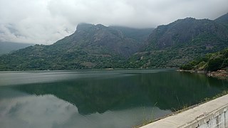
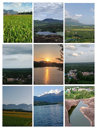
Thevaram is a town in Theni district in the Indian state of Tamil Nadu. Thevaram is located in Tamil Nadu near the border of Kerala at the Eastern side foot-hill of the Western Ghats. It is connected with State Highway SH100.

Vadavalli is a neighborhood in Coimbatore in the Indian state of Tamil Nadu. It is located on the Marudamalai Road and has been under the jurisdiction of the Coimbatore City Municipal Corporation limits since 2007. Located at the foothills of the Western Ghats, Vadavalli has a pleasant climate all through the year and has good ground water resources.
Vasudevanallur is a town panchayat located 37 km from Tenkasi district in the Indian state of Tamil Nadu. It is located under the Western Ghats. This town is surrounded by farming land. Major occupation of people of this town seems farming especially paddy, sugarcane, lemon and etc., This town is being best for education among the district for both schooling and colleges.
Vickramasingapuram or V.K.Puram is a Municipal town in Tirunelveli District in the Indian state of Tamil Nadu. It falls under the Ambasamudram Taluk. As of 2011, the town had a population of 47,241.
Sivagiri is a panchayat town and a tourist place in Tenkasi district in the Indian state of Tamil Nadu. Sivagiri is located at a distance of 50 km north to Tenkasi, 20 km south to Rajapalayam, 95 km north-west to Tirunelveli, 95 km south to Madurai, 540 km south to Bangalore, 150 km north to Thiruvananthapuram and 580 km south to the state capital Chennai.
Rajakkad is a town in the Idukki district in the Indian state of Kerala situated in the Western Ghats.

Aralam is a village and Grama Panchayat in Kannur district in the Indian state of Kerala.

