Uthamapalayam is a town and a taluka headquarters in Theni district in the Indianstate of Tamil Nadu. Uthamapalayam, a beautiful town in today's Theni district, has witnessed the influence of various rulers throughout history. In ancient times, it was under the Pandya dynasty. Later, it became an important region during the rule of the Madurai Nayaks. After the decline of the Nayaks, the area was governed by local chieftains known as Poligars (PalaiyakkaraRauthers).
In the 18th century, the region experienced the impact of Marathas and the Mysore kingdom. Particularly, when Hyder Ali and Tipu Sultan captured the Dindigul Fort, areas near Uthamapalayam came under their influence. However, Uthamapalayam was not directly annexed by Mysore; it remained under the control of the Poligars(PalaiyakkaraRauthers)..
After the Polygar Wars (1799–1805), the British took over this region. Subsequently, Uthamapalayam became part of Madurai District under the Madras Presidency. In the late 19th century, the commencement of the Mullaiperiyar Dam project (1886) brought significant agricultural development to Uthamapalayam and the Cumbum Valley.
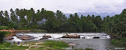
Today, Uthamapalayam stands proud with its historical legacy, advancing in education, agriculture, and cultural growth. Mullaiperiyar river is one of the attraction for this town.
Haji Karutha Rowther
Hajee Karutha Rowther, born in 1888 in Uthamapalayam (present-day Theni district, Tamil Nadu), belonged to an agricultural family. His real name was S. Mohamed Meeran Rowther, and he earned the nickname “Karutha Rowther” due to his dark complexion. Despite limited formal education, he strongly believed in the transformative power of education.
Known as the “Father of Education in Theni District”, he dedicated his life to uplifting rural students. In 1956, he founded Hajee Karutha Rowther Howdia College, the first rural college in the then Madurai district, donating 58.81 acres of land and ₹2 lakh for its establishment. The college was inaugurated by Chief Minister K. Kamaraj. He also started a Residential Madrasa (1914) and a Primary School, offering free education and boarding for poor students. His contributions extended to other institutions like Jamal Mohamed College (Trichy) and The New College (Chennai).
Role in Freedom Struggle and Social Work:
Hajee Karutha Rowther actively participated in the Indian Freedom Movement, including the Khilafat Movement and Non-Cooperation Movement. He promoted Khadi, opened a Khadi shop in Uthamapalayam, and worked alongside leaders like E.V. Ramasamy Periyar. He also funded to construct at Uthamapalayam Government Hospital in 1954 and supported communal harmony.
Samanar Kovil near Uthamapalayam – Traces of History
Uthamapalayam and its surrounding areas stand as a testimony to the ancient Jain traditions of Tamil Nadu. The word “Samanar” refers to the Jain faith (derived from the Sanskrit word Śramaṇa, meaning ascetic). In this region, caves, rock carvings, and inscriptions dating back over 2,000 years can still be found, where Jain monks once lived.
“A Jain monk accepted Islam and began preaching it to the local people. He later became a Sufi saint and was buried on a small hill, which is now known as Sayabu Malaiat Uthamapalayam.”
Temple
Shri Kalatheeswarar Temple, 500 years old, is a Sivan Temple located in Uthamapalayam, Theni District. Located 29km from the Theni. This temple is named "THEN KALAKASTHI" (South Kalakasthi). Kalatheeswarar Temple placing statues of the other god in identical roles as the Temple of Kalakasthi, Andhra Pradesh. East facing Kannappar Shrine, Grahas Raghu & Kedhu also has an individual shrines there. Every Sunday Pooja darshan for Moolavar (Lord Sivan) happens at Raghu time.[citation needed]
Shri Yoga Narasimha Perumal Temple
Shri Narasingam Yoga Narasimha Perumal Temple, 50 years old, is a Vishnu Temple located in Uthamapalayam.
Shri Muthu Karuppana Swami Kovil
Shri Muthu Karuppana Swami Kovil, is located in Uthamapalayam. It is Locally named for the Karuppa Samy Temple at the foot of the Tirukunnagiri hills.
As of 2011[update] India census,[2] Uthamapalayam had a population of 29,050. 10% of the population is under 6 years of age. Uthamapalayam has an average literacy rate of 73%, higher than the national average of 59.5%: The literacy rate of male and female is 80 and 66% respectively. Uthamapalayam is the headquarters of Uthamapalayam Taluk and Uthamapalayam Panchayat Union.
Government
Subordinate judge court along with one judicial magistrate court, one judicial magistrate fast track court and one district munsif court.
Climate
Southwest Monsoon and Northeast Monsoon contributes to the rainfall significantly. Being part of Theni it is one of the lush places in Tamil Nadu with high rainfall in most months. The place has a tropical climate with warm weather throughout the year.
Government Higher Secondary School and Mohamed Fathima Girls' High School are very famous in this taluk. A government aided arts and sciences college named Hajee Karutha Rowther Howdia College is serving over fifty years. This is the first college in this part of the state after independence.
The town is surrounded with small villages to moderate towns like Kombai, Chinamanur, Cumbam, Royapanpatti, Kurumbapatti (Ambasamuthram), Ammapatti, Ellapatti, Thevaram and Bodi.
This page is based on this Wikipedia article Text is available under the CC BY-SA 4.0 license; additional terms may apply. Images, videos and audio are available under their respective licenses.