Palani Chettipatti

Last updated

Palani Chettipatti

P.C. Patti
city
Palanichettipattidam.JPG
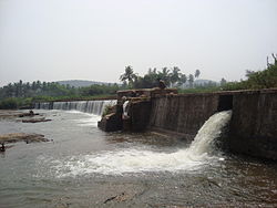
Palanichettipatti Dam
India Tamil Nadu location map.svg
Red pog.svg
Palani Chettipatti
Location in Tamil Nadu, India
Coordinates: 9°59′33″N77°27′30″E / 9.99250°N 77.45833°E / 9.99250; 77.45833 Coordinates: 9°59′33″N77°27′30″E / 9.99250°N 77.45833°E / 9.99250; 77.45833
CountryFlag of India.svg  India
State Tamil Nadu
District Theni
Population
 (2001)
  Total11,750
Languages
  Official Tamil
Time zone UTC+5:30 (IST)

Palani Chettipatti (P.C. Patti) is a panchayat town in Theni district in the Indian state of Tamil Nadu. It is located on the road between Theni and Cumbum. The Mullai river flows via this town from Uthamapalayam and goes down the valley.

Contents

History

Palaniappa Chettiar Palaniappa.jpg
Palaniappa Chettiar

It was founded by Palaniappa Chettiar. He and his family members constructed a small dam across the suruliyar river basin in 1840–1845, when John Black Burn was the district collector and magistrate of Madurai-Ramnad Jilla well before the Mullaperiyar Dam was constructed by Colonel John PennyCuick(1895). This dam is used for the irrigation and drinking water supply for several places: Theni - Allinagaram, Palanichettipatti and some near by villages. This dam has the distinction of being the *only* privately owned dam in Tamil Nadu. The founder, Palaniappa Chettiar, was one of the biggest contributors to the construction of the Mullaperiyar Dam.

Demographics

As of 2001 India census, [1] Palani Chettipatti had a population of 11,750. Males constitute 51% of the population and females 49%. Palani Chettipatti has an average literacy rate of 75%, higher than the national average of 59.5%: male literacy is 80%, and female literacy is 68%. In Palani Chettipatti, 12% of the population is under 6 years.

Education

Schools

A Government Aided School, Palaniappa Memorial Higher Secondary School provides low cost education to thousands of students in the nearby rural areas.

Related Research Articles

Kanyakumari district District of Tamil Nadu in India

Kanyakumari district is one of the 38 districts in Tamil Nadu state and the southernmost district in mainland India. It stands second in terms of population density among the districts of Tamil Nadu and the second most urbanized, next only to Chennai district. It is also the richest district in Tamil Nadu in terms of per capita income, and also tops the state in Human Development Index (HDI), literacy, and education. The district's headquarters is Nagercoil.

Puduvayal Town in Tamil Nadu, India

Puduvayal is a town in Karaikudi taluk, a well planned lay out town like pandicherry, Sivaganga district in the Indian state of Tamil Nadu. It is a town located in the Chettinad region of the Sivagangai district. On road, it is 12 km away from Karaikudi and 21 km away from Aranthangi. This town is famous for its rice mills. Puduvayal is the 2nd largest rice producer in Tamil Nadu. Puduvayal is an important commercial centre for trade in the Sivaganga district and part of the suburban region of Karaikudi. The town is famous for its Veerasekara Umaiyambigai Temple. Nearby Kandanur is famous for Kandanur Sivan Kovil—which is a replica of the Madurai Meenakshi Temple—built by Nagarthars.

Singampunari Town Panchayat in Tamil Nadu, India

Singampunari is a town in Sivagangai district, in Tamil Nadu, India. The town comes under Singampunari taluk.

Andipatti Jakkampatti Town in Tamil Nadu, India

Andipatti is a Panchayat town in Theni district, Madurai Region, At the state of Tamil Nadu, India.

Avalpoondurai Town Panchayat in Tamil Nadu, India

Avalpoondurai is a panchayat town in Erode district in the state of Tamil Nadu, India. It is situate 14 kilometres from Erode and an important junction on SH-83A en route to Dharapuram and other important small towns like Modakuruchi and Elumathur. It is about 415 km from Chennai,100 km from palani,100 km from Coimbatore, 50 km from Tiruppur and from Gobicheittipalayam.

Ayakudi city in Tamil Nadu, India

Ayakudi is a panchayat town in Dindigul district in the state of Tamil Nadu, India. Ayakudi is thought to be the place where the kings of Ay Kingdom originated. The city is known for guava. It is filled with nature in the slopes of Kodaikanal.

Boothipuram city in Tamil Nadu, India

Boothipuram is a panchayat town in Theni district in the state of Tamil Nadu, India.

Devadanapatti City in Tamil Nadu, India

Devadanapatti is a panchayat town in Periyakulam Taluk, a part of the Theni district in the Madurai Region in the state of Tamil Nadu, India. It is located at the bottom of the Kodaikanal Hills.

Dharapuram Historical town in Tamil Nadu, India

Dharapuram officially Tharaapuram is a town in Tirupur district in the Indian state of Tamil Nadu. Dharapuram is one of the oldest towns in Tamil Nadu and was the capital of Kongu Nadu under the Cheras, Western Ganga Dynasty and later Kongu Cholas, at which time it was known as Vanchipuri. Amaravathi River flows through the town. As of 2011, the town had a population of 67,007. Dharapuram Municipality is promoted 1st grade municipality on 6 May 1983 Dharapuram was Part of Coimbatore district in the beginning and later it moves to Erode district up to 2009. Dharapuram Town is situated along the banks of River Amaravathi, located in between 10 degree 45 minutes northern latitude and 77 degree 31 minutes eastern latitude with an extent of 7.02 km2. It is a small agricultural marketing centre for a large rural hinterland in the Tirupur District. The town is 50 km towards of the District Headquarters Tirupur, 75 km towards the Erode and 72 km towards the industrial town Coimbatore. The nearest airport is Coimbatore International Airport located 70 km from Dharapuram. Dharapuram was the capital of Noyyal South District before the formation of Coimbatore District.

Keeranur, Dindigul city in Tamil Nadu, India

Keeranur 624617 is a panchayat town in Dindigul district in the Indian state of Tamil Nadu. It is situated between Palani and Dharapuram. There are more than three places in Tamil Nadu and in the rest of India with the same name, a bigger Keeranur situated near Trichy.

Madathukulam municipality in Tamil Nadu, India

Madathukulam is Border to Dindigul District in Tirupur district in the Indian state of Tamil Nadu.

Manalmedu Panchayat Town in Tamil Nadu, India

Manalmedu is a panchayat town in Mayiladuthurai district in the Indian state of Tamil Nadu. It comes under Mayiladuthurai Taluk.This town is located 15 km from Mayiladuthurai town, 33 km from Kumbakonam and 15 km from kattumannarkoil town.

Mulanur Panchayat Town in Tamil Nadu, India

Mulanur is a panchayat town under in Dharapuram taluk in Tirupur District in the Indian state of Tamil Nadu.

Neikkarapatti village in Tamil Nadu, India

Neikkarapatti is a panchayat town in Dindigul district in the Indian state of Tamil Nadu.

Pattiveeranpatti Village in Tamil Nadu, India

Pattiveeranpatti is a panchayat town in Dindigul district in the Indian state of Tamil Nadu.

Theni Allinagaram Town in Tamil Nadu, India

Theni is a town and a municipality in Theni district in the Indian state of Tamil Nadu. As of 2011, the town had a population of 94,453.

Thevaram Town in Tamil Nadu, India

Thevaram is a town in Theni district in the Indian state of Tamil Nadu. Thevaram is located in Tamil Nadu near on border of Kerala at the Eastern side foot-hill of the Western Ghats. It is connected with State Highway SH100.

Vadipatti Panchayat town in Tamil Nadu, India

Vadipatti is a panchayat town in the Madurai district in the Indian state of Tamil Nadu. Population of the town is 21,833. The famous Festival for Bull are "Jallikattu","Manju virattu" or "Erudhukattu Vizha". The major "Jallikattu Protest" happened in the surroundings of this town.

Sukkangalpatti is a panchayat town in Theni district in the Indian state of Tamil Nadu.

Bodimettu Hill Station in Tamil Nadu, India

Bodimettu is a locality in Theni district in the state of Tamil Nadu in India, near the border with Kerala. It is 10 km from Poopara on the way to Bodinayakkanur by the side of National Highway 85, which runs from Dhanushkkodi to Kochi. Bodimettu is the main cardamom-growing area of Tamil Nadu. It is close to famous tourist destinations such as Munnar, Marayur, Thekkady, Kodaikanal, Anayirangal Dam.

References

  1. "Census of India 2001: Data from the 2001 Census, including cities, villages and towns (Provisional)". Census Commission of India. Archived from the original on 16 June 2004. Retrieved 1 November 2008.