Pannaipuram

Last updated

Pannaipuram
village
India Tamil Nadu location map.svg
Red pog.svg
Pannaipuram
Location in Tamil Nadu, India
Coordinates: 9°51′43″N77°16′19″E / 9.86194°N 77.27194°E / 9.86194; 77.27194
CountryFlag of India.svg  India
State Tamil Nadu
District Theni
Population
 (2011)
  Total9,323
Languages
  Official Tamil
Time zone UTC+5:30 (IST)
PIN
625 524
Vehicle registration TN 60

Pannaipuram is a panchayat town in Theni district in the Indian state of Tamil Nadu. It is located hill foot of "Western Ghats" sharing its border with Kerala State and has very good literacy.[ citation needed ] Pannaipuram Town panchayat includes 4 villages namely Pannaipuram, Kariyanampatty, Mallingapuram and P. Renganathapuram. Mahalingeswarar Temple, Kaliamman Temple and Bommaiyaswamy Temple are located in Pannaipuram. Veereswarar Temple is located in Kariyanampatty. Most of the people in Pannaipuram are engaged in Cardamom cultivation and trade in nearby Kerala hills.

Contents

Taluk: Uthamapalayam, District: Theni, Assembly Constituency: Cumbum (From 2011), earlier it was Bodinayakkanur. Parliament Constituency: Theni

Demographics

As of 2011 India census, [1] Pannaipuram had a population of 9323. Males constitute 49.6% of the population and females 50.4%. Pannaipuram has an average literacy rate of 74.93%, higher than the national average of 59.5%: male literacy is 82.58%, and female literacy is 67.42%. In Pannaipuram, 8.34% of the population is under 6 years of age.

Name

In Tamil Pannai means farm and puram means place or ground. People who lived in the village were agri and cattle farmers. The cattle grazing grounds were at the western ghats foothills adjacent to the village, hence the origin of name Pannaipuram.

Agriculture

Agriculture, cattle farms and brick manufacture are the major revenue source at Pannaipuram. Most of the tropical vegetables are grown. Many of the residents of the village have Cardamom, Coffee, Tea, Black Pepper, Clove, Coco and beetle-nut plantations in the adjacent hills of western ghats. After the state divide on language basis the hills are now part of Kerala.

Water Resources

Underground water was fully depleted, as the cultivation relies only on the same. The 18th canal project completed in 2008 and the rain water harvesting has helped in raising the ground water level. This has helped farming and agriculture in and around the village. Drinking water is drawn from the Mullai Periyar river running through the nearby town Uthamapalayam.

Flora and Fona

Neem, hibiscus, fig, wild berries, Indian black berries, coconut, mango, lemon, banana, Guyava, moringa and mostly tropical vegetation found in this region.

Birds

Common sighting of peacocks and peahens, roosters, hens, crows, sparrows, pigeons and parrots are found in this region

Personalities

Panaipuram is birthplace of the prominent film personalities; Indian music director Ilaiyaraaja and his family; Gangai Amaran who is also a music director film director is his brother. Yuvan Shankar Raja and Karthik Raja are his sons, Bhavatharini is his daughter. The Goa Vinnarasu close aide of Mustafa Baskar, incumbent president of Crushers Association of Andaman and Nicobar.

Neutrino Project

Pannaipuram is just 5 kilometres south of the proposed Indian Neutrino observatory site, which would be in the Bodi West Hills. [2]

Windmills

There are several windmills installed around the village, and currently generating energy.

Related Research Articles

<span class="mw-page-title-main">Theni</span> Neighbourhood in Tamil Nadu, India

Theni is a valley town situated in the Indian state of Tamil Nadu at the foothills of Western Ghats. It is the headquarters of the Theni district, located at a distance of 70km from Madurai. It is known for the large-scale trading of garlic, cotton, cardamom, grapes, bananas, mango and chilli. It hosts the second largest weekly market in Tamil Nadu and the fourth largest in South India.

<span class="mw-page-title-main">Theni district</span> District of Tamil Nadu in India

Theni District is one of the 38 districts of Tamil Nadu state in India. Well protected by the scenic hill locks, the district is located besides Madurai district. The town of Theni is the district headquarters. The district is divided into two natural divisions: The hilly areas are constituted by parts of the five taluk's Theni, Bodinayakanur, Periyakulam, Uthamapalayam and Andipatti with thick vegetation and perennial streams from the hills on the western side and Cumbum valley which lies in Uthamapalayam taluk. As of 2011, Theni district had a population of 1,245,899 with a sex ratio of 980 females for every 1,000 males.

<span class="mw-page-title-main">Batlagundu</span> City in Tamil Nadu, India

Batlagundu is a town in Nilakottai block in Dindigul district in the Madurai Region state of Tamil Nadu, India. The name Vetrilaikkundru later transformed and changed to Vathalagundu. The town is the major gateway to Kodaikanal. Subramaniya Siva was a writer, Indian Freedom Fighter, and activist born in Batlagundu. Batlagundu is the fifth-largest town in the Dindigul district. The town is located in such a way connecting three main districts of South Tamil Nadu. Batlagundu has most of the voters in Nilakottai Constituency.

Devadanapatti is a panchayat town in Periyakulam Taluk, a part of the Theni district in the Madurai Region in the state of Tamil Nadu, India. It is located at the bottom of the Kodaikanal Hills.

Elumalai is a Panchayat town in the district of Madurai, in the Indian state of Tamil Nadu. Originally named Aezhumalai, the town is located near Usilampatti (18 km), Madurai (58 km), Theni (56 km), Peraiyur (24 km) and Tirumangalam (40 km) in the Western ghats.

Cumbum, natively spelt as Kambam, is a town and municipality in Theni district, an Indian state of Tamil Nadu.

O' Valley or Ouchterlony Valley is a Town Panchayat in the Gudalur Taluk of The Nilgiris district in the Indian state of Tamil Nadu. The name is a contraction of an older name after a James Ouchterlony, who established coffee plantations in the area. This panchayat area is surrounded with beautiful mountains, and the waterfalls from the mountains add to the visual treat. One can enjoy by seeing cardamom, clove, pepper, tea and coffee plantations on the way to O' Valley. The place being located between Mudumalai National Park and New Amarambalam Reserved Forest, is famous for its flora and fauna. The place is surrounded by valleys, streams and water falls of which the sound is very soothing and is a mesmeric effect.

<span class="mw-page-title-main">Palani Chettipatti</span> Village in Tamil Nadu, India

Palani Chettipatti is a panchayat grama in Theni district in the Indian state of Tamil Nadu. It is located on the road between Theni and Cumbum. The Mullai river flows via this village from Uthamapalayam and goes down the valley pin code is 625531.

Pattiveeranpatti is a panchayat town in Dindigul district in the Indian state of Tamil Nadu.

<span class="mw-page-title-main">Theni Allinagaram</span> Town in Tamil Nadu, India

Theni Allinagaram is a valley town and a municipality, situated in the Indian state of Tamil Nadu at the foothills of Western Ghats. It is the headquarters of the Theni district, located at a distance of 70 km from Madurai. As of 2011, the town had a population of 94,453. The metro area had the population of 202,100. It is known for the large-scale trading of garlic, cotton, cardamom, grapes, bananas, mango and chilli. It hosts the second largest weekly market in Tamil Nadu and the fourth largest in South India.

Thevaram is a town in Theni district in the Indian state of Tamil Nadu. Thevaram is located in Tamil Nadu near on border of Kerala at the Eastern side foot-hill of the Western Ghats. It is connected with State Highway SH100.
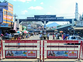
<span class="mw-page-title-main">Uthamapalayam</span> Town Panchayat in Tamil Nadu, India

Uthamapalayam is a town and a taluka headquarters in Theni district in the Indian state of Tamil Nadu. Mullaiperiyar river is one of the attraction for this town.

Kombai is a panchayat town in Theni District in the Indian state of Tamil Nadu, located in the beautiful foot hills of Western Ghats, blessed by mother nature with all pancha boota - Land, Water, Fire, Air and Ether. The town is known for its splendid nature, culture, diversity and ethnicity, history, landmarks and flourishing transformation.

<span class="mw-page-title-main">Kumily</span> Plantation Town in Kerala, India

Kumuli, also spelt as Kumily is a revenue village and Gram Panchayat in the Idukki district of the state of Kerala. It is a town in Cardamom Hills near Thekkady and Periyar Tiger Reserve. Kumuli is a gateway town into Tamil Nadu from Kerala.

<span class="mw-page-title-main">Suruli Falls</span> Waterfall in Tamil Nadu, India

Suruli falls, is located 56 km (35 mi) from Theni and 10 km (6.2 mi) from Cumbum in the Theni District in Tamil Nadu, India. It is a 2 stage Cascading water fall. The Suruli River supplying the falls originates from the Meghamalai mountain range. The falls drop from a height of 150 feet (46 m) gathers into a pool, flows for a short distance and again plummets an additional 40 feet (12 m).

<span class="mw-page-title-main">India-based Neutrino Observatory</span> Indian physics research project

India-based Neutrino Observatory (INO) is a particle physics research project under construction to primarily study atmospheric neutrinos in a 1,200 meters (3,900 ft) deep cave under INO Peak near Theni, Tamil Nadu, India. This project is notable in that it is anticipated to provide a precise measurement of neutrino mixing parameters. The project is a multi-institute collaboration and one of the biggest experimental particle physics projects undertaken in India.

Uthamapalayam taluk is a taluk of Theni district of the Indian state of Tamil Nadu. The headquarters of the taluk is the town of Uthamapalayam.

Sukkangalpatti is a panchayat town in Theni district in the Indian state of Tamil Nadu.

<span class="mw-page-title-main">Anakkara (Idukki)</span> Village in Kerala, India

Anakkara is a geographic area of around 50 square kilometres that spans across Vandanmedu, Chakkupallam Panchayats in the Udumbanchola Taluk of Idukki District. Anakkara is the administrative capital of Chakkupallam Grama Panchayat and Anakkara Revenue Village. Situated at about 18 kilometers (11 mi) from Thekkady wildlife sanctuary on the Kumily-Munnar state highway, Anakkara is a fast-growing tourist destination for its unique spice gardens and many picnic spots in and around. It is one of the 36 distinct places identified by Government of India and United Nations Development Programme for exploring and promoting the unique tourism potential of these places.

<span class="mw-page-title-main">Bodimettu</span> Hill Station in Tamil Nadu, India

Bodimettu is a locality in Theni district in the state of Tamil Nadu in India, near the border with Kerala. It is 10 km from Poopara on the way to Bodinayakkanur by the side of National Highway 85, which runs from Dhanushkodi to Kochi. Bodimettu is the main cardamom-growing area of Tamil Nadu. It is close to famous tourist destinations such as Munnar, Marayur, Thekkady, Kodaikanal, Anayirangal Dam.

References

  1. "Census of India 2011: Data from the 2011 Census, including cities, villages and towns (Provisional)". Census Commission of India. Archived from the original on 16 June 2004. Retrieved 1 November 2011.
  2. "India-based Neutrino Observatory project gets Centre's approval, ball in Tamil Nadu's court". The New Indian Express. Archived from the original on 18 March 2018. Retrieved 27 October 2022.