Thirupuvanam, Sivaganga

Last updated

Thiruppuvanam
Town
Nickname: 
Town of billhook
Coordinates: 9°49′37″N 78°15′24″E
CountryFlag of India.svg  India
State Tamil Nadu
District Sivaganga
Government
  TypeTaluk
  BodyThiruppuvanam Town Panchayat
Area
  Total20 km2 (8 sq mi)
Elevation
108 m (354 ft)
Population
 (2011)
  Total21,350
  Density1,100/km2 (2,800/sq mi)
Demonym puvaniyams
Languages
  Official Tamil
Time zone UTC+5:30 (IST)
Vehicle registration TN 63
Website http://www.townpanchayat.in/thiruppuvanam

Thiruppuvanam is a town in Manamadurai Constituency and also Manamadurai division in the Indian state of Tamil Nadu. [1] [2] [3]

Contents

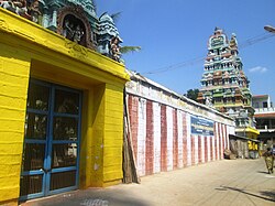
Pushpavaneswarar temple (870-970 CE) Thirupuvanam Temple.jpg
Pushpavaneswarar temple (870–970 CE)

Geography

The town is located in the bank of the Vaigai river. The town lies through NH47 starts from Ernakulam to Dhanushkodi.

Demographics

Population

As of 2011 India census, [4] Thiruppuvanam had a population of 21,435. Males constitute 50% of the population and females 50%. Thiruppuvanam has an average literacy rate of 74%, higher than the national average of 59.5%: male literacy is 81%, and female literacy is 66%.

Government and politics

This taluk is carved out from Manamadurai taluk. This taluk consist of 3 firkas namely Thiruppuvanam, Thiruppachetti (Thirupachi) and Konthagai

Civic Utility / Amenities / Services

This town has a police station, society and operation of a fire station is in talks.

Economy

Culture/Cityscape

Tourist Attractions

Pushpavaneswarar temple, which is one of the Padal Petra Shiva sthalams. [5]

Transport

Thiruppuvanam is situated nearby the Temple city of Madurai. on Madurai-Rameswaram National Highway and 18 km to the east of Madurai. Thiruppuvanam falls under Manamadurai assembly.

By Air

The nearby airport is Madurai international airport In THIRUPPUVANAM town

By Road

The town has a railway station which is connected with Madurai city. It is the only block in Sivagangai district which comes under the region of Madurai, due to which most of the facilities given to Madurai and its surrounding areas will be available mostly here. Moreover, it is the only block in the Sivagangai district which has the Madurai city bus facilities and also the Sivagangai bus services. This town is famous for billhook. This town has a TNSTC depot and it is one of the two depots of Madurai division which is operating beyond Madurai district.

Education

Due to its nearby location to the city of madurai, many schools, colleges and several industries are present in this taluk and around this town. It is mainly due to the transportation available in this area from madurai.

Related Research Articles

<span class="mw-page-title-main">Aruppukkottai</span> Town in Tamil Nadu, India

Aruppukottai is a town and a municipality in Virudhunagar district in the state of Tamil Nadu, India. Aruppukottai's classical name is "Sengattu Aravakotai". Aruppukottai is about 50 km from Madurai. It is in the middle of Madurai-Tuticorin National Highways NH-38. The villages and towns surrounding Aruppukottai makes this as a major town as well as a major transit hub and they are also famous for production of jasmine. Aruppukottai is always famous for producing yarn. Sri Ramana Maharishi was born in Tiruchuli near Aruppukottai town. Aruppukottai was part of king Sethupathi of Ramnad. King Sethupathi has Zamin Palace in Palyampatti. As of 2011, the town had a population of 87,722. The town also hosts two famous temples – Arulmigu Meenakshi Chokkanatha Swamy Temple built in 13th century by Pandiya King Maravarma Sundarapandiyan and Seenivasa Perumal Temple Built on the top of Malai arasan Hill.

<span class="mw-page-title-main">Karaikudi</span> City Corporation in Tamil Nadu, India

Karaikudi is the largest city in Sivaganga district in the Indian state of Tamil Nadu. Karaikudi Urban Agglomoration is the 21st largest urban area of Tamil Nadu based on 2011 census data. It is part of the area commonly referred to as "Chettinad" and has been declared a City Municipal Corporation by the Government of Tamil Nadu, on account of the palatial houses built with limestone called Kaarai veedu. For this reason, the place is sometimes called Kaarai Nagar locally. The newly formed Karaikudi Municipal Corporation spreads about 94.31 km2 (36.41 sq mi) which undergoes major developments as part of Government Schemes.

Ramanathapuram, also known as Ramnad, is a city and a municipality in Ramanathapuram district in the Indian state of Tamil Nadu. It is the administrative headquarters of Ramanathapuram district and the second largest town in Ramanathapuram district. Soon the Ramanathapuram Civic body to be upgraded as Municipal Corporation, after merging with nearby panchayats.

<span class="mw-page-title-main">Sivaganga</span> Municipality in Tamil Nadu, India

Sivaganga is a Municipality and headquarters of the Sivaganga district in the Indian state of Tamil Nadu.It was the second populous Town in the district after Karaikudi

<span class="mw-page-title-main">Palani</span> Town in Tamil Nadu, India

Palani (Tamil:[paɻani], is a town and a taluk headquarters in Dindigul district of the western part of Tamil Nadu state in India. It is located about 106 kilometres south-east of Coimbatore and 122 kilometres north-west of Madurai, 67 kilometres from Kodaikanal. The Palani Murugan Temple or Arulmigu Dhandayuthapani Swamy Temple, dedicated to Murugan is situated on a hill overlooking the town. The temple is visited by more than 7 million pilgrims each year. As of 2011, the town had a population of 70,467 and the Taluk had a population of 292,301 which makes it the second largest town in the district after Dindigul.

<span class="mw-page-title-main">Melur</span> Municipality in Tamil Nadu, India

Melur is the Northern entrance of Madurai district. It is the town and municipality in the Madurai North in the Indian state of Tamil Nadu. Melur Old Name is Called Naduvi Nadu. The name Melur name comes from "Mela Nadu". Melur is called Thaigramam. It is the biggest taluk within the Madurai District. As of 2011, the town had a population of 40,017. Melur is an agricultural land in Madurai and the climate around the area is tropical.

<span class="mw-page-title-main">Puduvayal</span> Town in Tamil Nadu, India

Puduvayal is a town in Karaikudi taluk, Sivaganga district in the Indian state of Tamil Nadu. It is a town located in the Chettinad region of the Sivagangai district. On road, it is 12 km away from Karaikudi and 21 km away from Aranthangi. This town is famous for its rice mills. Puduvayal is the 2nd largest rice producer in Tamil Nadu. Puduvayal is an important commercial centre for trade in the Sivaganga district and part of the suburban region of Karaikudi. The town is famous for its Veerasekara Umaiyambigai Temple. Nearby Kandanur is famous for Kandanur Sivan Kovil—which is a replica of the Madurai Meenakshi Temple—built by Nagarthars.

<span class="mw-page-title-main">Sivaganga district</span> Place in Tamil Nadu, India

Sivaganga District is one of the 38 districts in Tamil Nadu state, India. This district was formed on 15 March 1985 by trifurcation of Ramanathapuram district into Ramanathapuram, Virudhunagar and Sivaganga districts. Sivaganga is the district headquarters, while Karaikudi is the most populous city in the district, administered by the Karaikudi Municipal Corporation. It is bounded by Pudukkottai district on the Northeast, Tiruchirappalli district on the North, Ramanathapuram district on South East, Virudhunagar district on South West and Madurai district on the West. The area's other larger towns include Sivaganga, Kalayar Kovil, Devakottai, Manamadurai, Ilaiyangudi, Thiruppuvanam, Singampunari and Tiruppattur. As of 2011, the district had a population of 1,339,101 with a sex ratio of 1,003 females for every 1,000 males.

<span class="mw-page-title-main">Tiruttani</span> Town in Tamil Nadu, India

Tiruttani is a historic temple town situated in the Tiruvallur district and serves as a suburb of Chennai within the Chennai Metropolitan Area in the southern Indian state of Tamil Nadu. The town is famous for the Tiruttani Murugan Temple, an ancient Hindu temple dedicated to Kartikeya, also known as Murugan, the Hindu god of war. This temple is one of the Arupadaiveedu, a group of six significant abodes of Murugan. Tiruttani was officially incorporated into the Chennai Metropolitan Area in October 2022, signifying its growing importance and influence within the region..

<span class="mw-page-title-main">Dharapuram</span> Historical town in Tamil Nadu, India

Dharapuram is a town situated along the banks of Amaravati River in Tiruppur district in the Indian state of Tamil Nadu. Dharapuram is one of the oldest towns in South India and was the capital of Kongu Nadu under the Cheras, Western Ganga Dynasty and later Kongu Cholas, at which time it was known as Viradapuram. Amaravathi River flows through the town. As of 2011, the town had a population of 67,007. The city houses famous temples including Agatheeswarar Temple, Kaadu Hanumanthasamy temple and many others.

<span class="mw-page-title-main">Manamadurai</span> A First Grade Municipality in Sivagangai District

Manamadurai is a Municipality Town in Sivaganga district in the Indian state of Tamil Nadu. Manamadurai falls under Manamadurai Legislative assembly. It is a river based settlement town. River Vaigai makes its way through the town bifurcating it into two parts.

Nanguneri is a panchayat town in Tirunelveli district in the Indian state of Tamil Nadu.

<span class="mw-page-title-main">Thuraiyur</span> Municipality in Tamil Nadu, India

Thuraiyur is a municipality in the Tiruchirappalli district in the Indian state of Tamil Nadu. It was upgraded to a III Grade Municipality from Town Panchayat on 17 January 1970, and to a II Grade Municipality in May 1998. It was upgraded to Selection Grade Municipality in the year 2008. It is also a taluka. It is located 310 km away from Chennai.

<span class="mw-page-title-main">Usilampatti</span> Town in Tamil Nadu, India

Usilampatti is a town and a second grade municipality of Madurai district in the Indian state of Tamil Nadu. It is also a designated taluk and revenue division.

T. Vadipatti is a panchayat town in the Madurai district in the Indian state of Tamil Nadu.and also known as "west gateway of Madurai.

Kulasekharam is a town located in the district of Kanyakumari, Tamil Nadu, India. It is one of the most important business centres in the district, after Marthandam.

<span class="mw-page-title-main">Sengottai</span> Town in Tamil Nadu, India

Sengottai is a town in the Tenkasi district, of Tamil Nadu, India. It is the gateway to southern Tamil Nadu and Kerala. Spread over an area of 2.68 km2 with a population of over 26,823, the economy of the town and Sengottai Taluk revolves around the cultivation of rice,coconut,Mango,clove and pepper. Sengottai is well known in Tamil Nadu as a major market of Dosa kal. This town has lot of Black smith shops.

<span class="mw-page-title-main">Sivaganga Lok Sabha constituency</span> One of the 39 Parliamentary Constituencies in Tamil Nadu, in India.

Sivaganga Lok Sabha constituency is one of the 39 Lok Sabha (parliamentary) constituencies in Tamil Nadu, a state in southern India. Its Tamil Nadu Parliamentary Constituency number is 31.

Thirupachethi is a Town in manamadurai block Sivagangai District on the highway of Madurai-Rameswaram (NH-49) in Tamil Nadu, India.

<span class="mw-page-title-main">Manamadurai Junction railway station</span> Railway station in Tamil Nadu, India

Manamadurai Junction railway station is an NSG–5 category Indian railway station in Madurai railway division of Southern Railway zone. It serves Manamadurai, located in Sivaganga district of the Indian state of Tamil Nadu. It is one of the two major railway junctions in Sivaganga district and the other one is Karaikudi Junction. Manamadurai junction is a Four branched junction. It has totally 5 platforms, in which only 3 are functioning and last two are used for unscheduled dockings and freight train docking.

References

  1. "Government of Tamil Nadu"
  2. "Government of Tamil Nadu"
  3. "Government of Tamil Nadu"
  4. "Census of India 2001: Data from the 2001 Census, including cities, villages and towns (Provisional)". Census Commission of India. Archived from the original on 16 June 2004. Retrieved 1 November 2008.
  5. Pushpavaneswarar temple is holier than Kasi."Dinamalar", Sri Pushpavaneswarar temple

9°51′18″N78°16′28″E / 9.85500°N 78.27444°E / 9.85500; 78.27444