
The Central Provinces and Berar was a province of British India and later the Dominion of India which existed from 1903 to 1950. It was formed by the merger of the Central Provinces with the province of Berar, which was territory leased by the British from the Hyderabad State. Through an agreement signed on 5 November 1902, 6th Nizam Mahbub Ali Khan, Asaf Jah VI leased Berar permanently to the British for an annual payment of 25 lakhs rupees. Lord Curzon decided to merge Berar with the Central Provinces, and this was proclaimed on 17 September 1903.
Vidarbha is a geographical region in the east of the Indian state of Maharashtra and a proposed state of western India, comprising the state's Amravati and Nagpur divisions. Amravati Division's former name is Berar. It occupies 31.6% of the total area and holds 21.3% of the total population of Maharashtra. It borders the state of Madhya Pradesh to the north, Chhattisgarh to the east, Telangana to the south and Marathwada and Uttar Maharashtra regions of Maharashtra to the west. Situated in central India. The largest city in Vidarbha is Nagpur followed by Amravati, Akola, Chandrapur and Gondia. A majority of Vidarbha residents speak Varhadi and Zadi dialects of Marathi.
Amravati is the second largest city in the Vidarbha region and ninth largest city in Maharashtra, India. It is administrative headquarters of Amravati district and Amravati division which includes Akola, Buldhana, Washim, and Yavatmal districts. It is one of Maharashtra's nominated cities under Smart Cities Mission.
Yavatmal district, [jəʋət̪maːɭ] formerly known as Yeotmal, is a district of the Indian state of Maharashtra. It is located in the region of Vidarbha, in the east-central part of the state. It is Vidarbha's third-largest district by population, after Nagpur and Amravati. Yavatmal city is the administrative headquarters of the district.

Berar Province, also known as the Hyderabad Assigned Districts, was a province of Hyderabad. After 1853, it was administered by the British, although the Nizam retained formal sovereignty over the province. Azam Jah, the eldest son of the 7th Nizam, held the title of Mirza-Baig ("Prince") of Berar.
Akola is a major city in the Vidarbha region of the Indian state of Maharashtra. The third largest city in Eastern Maharashtra after Nagpur and Amravati, it is located about 580 kilometres (360 mi) east of the state capital, Mumbai, and 250 kilometres (160 mi) west of the second capital, Nagpur. Akola is the administrative headquarters of the Akola district located in the Amravati division.

Buldhana district is located in the Amravati division of Maharashtra, India. It is situated at the western border of Vidarbha region and is 500 km away from the state capital, Mumbai. The district has towns and cities like Shegaon, Malkapur, Khamgaon, Lonar and Chikhli. It is surrounded by Madhya Pradesh in the north, Akola, Washim, and Amravati districts on the east, Jalna district on the south, and Jalgaon and Aurangabad districts on the west. Khamgaon is the largest city in the district.

Amravati district is a district of Maharashtra state in central India. It is the administrative headquarter of Amravati division, which is one of the two divisions in Vidarbha, out of total 6 regions in state of Maharashtra.

Yavatmal ( is a city and municipal council in the Indian state of Maharashtra. It is the administrative headquarters of Yavatmal District. Yavatmal is around 90 km away from divisional headquarters Amravati while it is 670 km away from the state capital Mumbai and 150 km south west of Nagpur. Yavatmal District is on 2nd position in India after Kolkata and known for its unique Navratri festival celebration, and nearly total 2,766+ durga mata is installed in the whole district. Yavatmal is known for organising huge celebration events for Navratri.

Washim district is a district in Maharashtra, India. The headquarters is at Washim. The area of the district is 5,150 km2 (1,990 sq mi).

Akola district is a district in the Indian state of Maharashtra. The city of Akola is the district headquarters. Akola district forms the central part of Amravati Division, which was the former British Raj Berar Province.
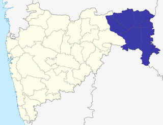
The Nagpur Division is one of six administrative divisions of the state of Maharashtra in India. Nagpur is the easternmost division in the state, with an administrative headquarters in the city of Nagpur. It covers 51,336 km² (19,821 mi²). The Amravati and Nagpur divisions make up the Vidarbha region.
Pusad is a city in the Yavatmal district located in Vidarbha region of Maharashtra state of India. It is named after the Pus river. Its ancient name was 'Pushpawanti'. Pusad is second largest city of Yavatmal district. For last 20 years Pusad is being tried to be promoted to the stature of district but due to lack of administration of governing bodies it is only a dream of the people.
Dr. Panjabrao Deshmukh Krishi Vidyapeeth is an agricultural university located at Akola, in Maharashtra, India, in the Vidarbha region. The university is entrusted with the responsibility of agricultural education, research and extension education along with breeder and foundation seed programmes.

Achalpur, formerly known as Ellichpur and Illychpur, is a city and a municipal council in Amravati District in the Indian state of Maharashtra. It is the second most populous city in Amravati District after Amravati and seventh most populous city in Vidarbha. Achalpur camp is known as Paratwada.
Paratwada, formerly known as Paltanwada and also known as "Achalpur Camp" is a city and a municipal council in Amravati District in the Indian state of Maharashtra. It is also the second most populous city in Amravati District after Amravati and seventh most populous city in Vidarbha. It has a twin city known as Achalpur. Paratwada is a gateway to the Melghat region which has one of the biggest Tiger conservation projects in India.
The Berar Division, formerly Berar Province, was one of the former administrative divisions of the Central Provinces and Berar of British India. Ellichpur (Achalpur) was the capital and the administrative headquarters of the division.

Bhusawal railway division is one of the five railway divisions of the Central Railway (India) zone of Indian Railways, located at Bhusawal in the Jalgaon district of Maharashtra state in western India. The other railway divisions are: Mumbai CSMT, Nagpur, Solapur and Pune. There are 115 railway stations in the Bhusawal railway division.
Akola Pact of 1947 was an agreement between the Congress leaders from Western Maharashtra and from then Central Provinces and Berar. It was for the creation of two sub-provinces of Mahavidarbha and Western Maharashtra. It envisaged two separate executive, legislation, judiciary and council of minister, but under a single Government.

