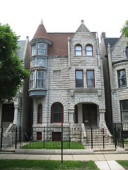
There are 178 official neighborhoods in Chicago. [1] Neighborhood names and identities have evolved due to real estate development and changing demographics. [2] Chicago is also divided into 77 community areas which were drawn by University of Chicago researchers in the late 1920s. [3] Chicago's community areas are well-defined, generally contain multiple neighborhoods, and depending on the neighborhood, less commonly used by residents. [2] [4]
The Loop is Chicago's central business district and one of the city's 77 municipally recognized community areas. Located at the center of downtown Chicago on the shores of Lake Michigan, it is the second-largest business district in North America after Midtown Manhattan. The headquarters and regional offices of several global and national businesses, retail establishments, restaurants, hotels, and theaters–as well as many of Chicago's most famous attractions–are located in the Loop. The neighborhood also hosts Chicago's City Hall, the seat of Cook County, offices of other levels of government, and several foreign consulates. The intersection of State Street and Madison Street in the Loop is the origin point for the address system on Chicago's street grid.
SoHo, short for "South of Houston Street", is a neighborhood in Lower Manhattan, New York City. Since the 1970s, the neighborhood has been the location of many artists' lofts and art galleries, and has also been known for its variety of shops ranging from trendy upscale boutiques to national and international chain store locations. The area's history is an archetypal example of inner-city regeneration and gentrification, encompassing socioeconomic, cultural, political, and architectural developments.
Washington Park is a community area on the South Side of Chicago which includes the 372 acre (1.5 km2) park of the same name, stretching east-west from Cottage Grove Avenue to the Dan Ryan Expressway, and north-south from 51st Street to 63rd. It is home to the DuSable Museum of African American History. The park was the proposed site of the Olympic Stadium and the Olympic Aquatics Center in Chicago's bid to host the 2016 Summer Olympics.
The city of Chicago is divided into 77 community areas for statistical and planning purposes. Census data and other statistics are tied to the areas, which serve as the basis for a variety of urban planning initiatives on both the local and regional levels. The areas' boundaries do not generally change, allowing comparisons of statistics across time. The areas are distinct from but related to the more numerous neighborhoods of Chicago; an area often corresponds to a neighborhood or encompasses several neighborhoods, but the areas do not always correspond to popular conceptions of the neighborhoods due to a number of factors including historical evolution and choices made by the creators of the areas. As of 2020, Near North Side is the most populous of the areas with over 105,000 residents, while Burnside is the least populous with just over 2,500. Other geographical divisions of Chicago exist, such as the "sides" with origin in the 3 branches of the Chicago River, the 50 wards of the Chicago City Council which undergo redistricting based in population movements, and the parishes of the Roman Catholic Church.
Mount Greenwood is one of the 77 community areas in Chicago. The 74th numbered area, it is about 14 miles (23 km) southwest of the Loop. It is surrounded by the neighborhoods of Beverly and Morgan Park to the east, the suburb of Evergreen Park to the north, the suburb of Oak Lawn to the west, and the suburbs of Merrionette Park and Alsip to the south. Mount Greenwood is known as the home of many Chicago firefighters, Chicago police officers, and union workers.
The Near South Side is a community area of Chicago, Illinois, United States, just south of the downtown central business district, the Loop. The Near South Side's boundaries are as follows: North—Roosevelt Road ; South—26th Street; West—Chicago River between Roosevelt and 18th Street, Clark Street between 18th Street and Cermak Road, Federal between Cermak Road and the Stevenson Expressway just south of 25th Street, and Clark Street again between the Stevenson and 26th Street; and East—Lake Michigan.
The Near West Side, one of the 77 community areas of Chicago, is on the West Side, west of the Chicago River and adjacent to the Loop. The Great Chicago Fire of 1871 started on the Near West Side. Waves of immigration shaped the history of the Near West Side of Chicago, including the founding of Hull House, a prominent settlement house. The near west side comprises several neighborhoods. In the 19th century railroads became prominent features. In the mid-20th century, the area saw the development of freeways centered in the Jane Byrne Interchange.
Douglas, on the South Side of Chicago, Illinois, is one of Chicago's 77 community areas. The neighborhood is named for Stephen A. Douglas, Illinois politician and Abraham Lincoln's political foe, whose estate included a tract of land given to the federal government. This tract later was developed for use as the Civil War Union training and prison camp, Camp Douglas, located in what is now the eastern portion of the Douglas neighborhood. Douglas gave that part of his estate at Cottage Grove and 35th to the Old University of Chicago. The Chicago 2016 Olympic bid planned for the Olympic Village to be constructed on a 37-acre (15 ha) truck parking lot, south of McCormick Place, that is mostly in the Douglas community area and partly in the Near South Side.
South Lawndale is a community area on the West Side of Chicago, Illinois. Over 80% of the residents are of Mexican descent and the community is home to the largest foreign-born Mexican population in Chicago.
Morgan Park, located on the far south side of the city of Chicago, Illinois, United States, is one of the city's 77 official community areas. Morgan Park is located south of the Beverly neighborhood and north of the Chicago city border, and includes Mount Greenwood Cemetery. The community, settled in the mid-19th century, was initially known as North Blue Island, being located close to the existing town of Blue Island to the south. As of 2013, Morgan Park was majority-black, with approximately 22,924 residents in 2015.
The Union Stock Yard & Transit Co., or The Yards, was the meatpacking district in Chicago for more than a century, starting in 1865. The district was operated by a group of railroad companies that acquired marshland and turned it into a centralized processing area. By the 1890s, the railroad capital behind the Union Stockyards was Vanderbilt money. The Union Stockyards operated in the New City community area for 106 years, helping Chicago become known as the "hog butcher for the world", the center of the American meatpacking industry for decades. The yards became inspiration for literature and social reform.
New City is one of Chicago's 77 official community areas, located on the southwest side of the city in the South Side district. It contains the neighborhoods of Canaryville and Back of the Yards. The boundaries of New City are Pershing Road to the north, Western Avenue/Boulevard and CSX railroad tracks to the west, Norfolk Southern railroad tracks to the east, and CSX / Orange Line tracks and Garfield Boulevard to the south.
Halsted Street is a major north-south street in the U.S. city of Chicago, Illinois.
Boston's diverse neighborhoods serve as a political and cultural organizing mechanism. The City of Boston's Office of Neighborhood Services has designated 23 Neighborhoods in the city:
Old Town is a neighborhood and historic district in Near North Side and Lincoln Park, Chicago, Illinois, home to many of Chicago's older, Victorian-era buildings, including St. Michael's Church, one of seven buildings to survive the Great Chicago Fire.
The Washington Park Court District is a Grand Boulevard community area neighborhood on the South Side of Chicago, Illinois. It was designated a Chicago Landmark on October 2, 1991. Despite its name, it is not located within either the Washington Park community area or the Washington Park park, but is one block north of both. The district was named for the Park.
The South Side is one of the three major sections of the city of Chicago, Illinois, United States. Geographically, it is the largest of the three sections of the city, with the other two being the North and West Sides. It radiates and lies south of the city's downtown area, the Chicago Loop.
Rush Street is a one-way street in the Near North Side community area of Chicago in Cook County, Illinois, United States. The street, which starts at the Chicago River between Wabash and North Michigan Avenues, runs directly north until it slants on a diagonal as it crosses Chicago Avenue then it continues to Cedar and State Streets, making it slightly less than a mile long. One lane also runs southbound from Ohio Street (600N) to Kinzie Street (400N) as part of a two-way street segment. It runs parallel to and one block west of the Magnificent Mile on the two-way traffic North Michigan Avenue, which runs at 100 east up to 950 north. The street, which is also one block east of the one-way southbound Wabash Avenue, formerly ran slightly further south to the Chicago River where over time various bridges connected it to the Loop, Chicago's central business district.
The West Side is one of the three major sections of the city of Chicago, Illinois, United States. It is joined by the North and South Sides. The West Side contains communities that are of historical and cultural importance to the history and development of Chicago. On the flag of Chicago, the West Side is represented by the central white stripe.
Gentrification, the process of altering the demographic and socioeconomic composition of a neighborhood usually by decreasing the percentage of low-income minority residents and increasing the percentage higher-income residents, has been an issue between the residents of minority neighborhoods in Chicago who believe the influx of new residents destabilizes their communities, and the gentrifiers who see it as a process that economically improves a neighborhood. Researchers have debated the significance of its effects on the neighborhoods and whether or not it leads to the displacement of residents.
Chicago's neighborhood borders and even their names may change, but fierce local identification remains intact. In the 1950s, nobody would have said they live in Village East or River North, but now most know those newly named neighborhoods ... Who names neighborhoods? Often developers looking for a quick buck name them. ... If you try to find Wrigleyville on the official community area map of Chicago, you will be disappointed, as you will be if you search out such legendary neighborhoods as Canaryville, Back of the Yards or Hamburg on the South Side.
Despite the uses scholars and planners have found for community areas, they do not necessarily represent how Chicagoans think about their city ... Prominent neighborhoods like PILSEN and BACK OF THE YARDS are subsumed into the less familiar LOWER WEST SIDE and NEW CITY.