
Michigan Avenue is a north-south street in Chicago that runs at 100 east on the Chicago grid. The northern end of the street is at DuSable Lake Shore Drive on the shore of Lake Michigan in the Gold Coast Historic District. The street's southern terminus is at Sibley Boulevard in the southern suburb of Dolton, but like many other Chicago streets, it exists in several disjointed segments.
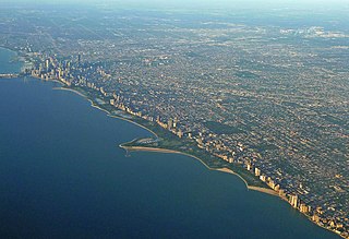
Lincoln Park is a 1,208-acre (489-hectare) park along Lake Michigan on the North Side of Chicago, Illinois. Named after US President Abraham Lincoln, it is the city's largest public park and stretches for seven miles (11 km) from Grand Avenue, on the south, to near Ardmore Avenue on the north, just north of the DuSable Lake Shore Drive terminus at Hollywood Avenue. Two museums and a zoo are located in the oldest part of the park between North Avenue and Diversey Parkway in the eponymous neighborhood. Further to the north, the park is characterized by parkland, beaches, recreational areas, nature reserves, and harbors. To the south, there is a more narrow strip of beaches east of Lake Shore Drive, almost to downtown. With 20 million visitors per year, Lincoln Park is the second-most-visited city park in the United States, behind Manhattan's Central Park.

Logan Square is an official community area, historical neighborhood, and public square on the northwest side of the City of Chicago. The Logan Square community area is one of the 77 city-designated community areas established for planning purposes. The Logan Square neighborhood, located within the Logan Square community area, is centered on the public square that serves as its namesake, located at the three-way intersection of Milwaukee Avenue, Logan Boulevard and Kedzie Boulevard.

Little Italy, sometimes combined with University Village into one neighborhood, is on the Near West Side of Chicago, Illinois. The current boundaries of Little Italy are Ashland Avenue on the west and Interstate 90/94 on the east, the Eisenhower Expressway on the north and Roosevelt to the south. It lies between the east side of the University of Illinois at Chicago campus in the Illinois Medical District and the west side of the University of Illinois at Chicago campus. The community was once predominantly Italian immigrants but now is made up of diverse ethnic and socio-economic backgrounds as a result of immigration, urban renewal, gentrification and the growth of the resident student and faculty population of the University of Illinois at Chicago (UIC). Its Italian-American heritage is primarily evident in the Italian-American restaurants that once lined Taylor Street. The neighborhood is home to the National Italian American Sports Hall of Fame as well as the historic Roman Catholic churches Our Lady of Pompeii, Notre Dame de Chicago, and Holy Family.
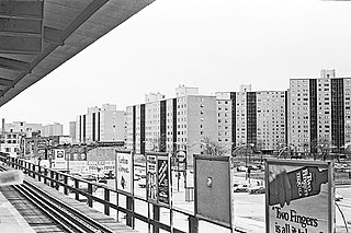
Stateway Gardens was a Chicago Housing Authority (CHA) public housing project in the Bronzeville neighborhood on the South Side of Chicago, Illinois, alongside the Dan Ryan Expressway just north of the former Robert Taylor Homes, and part of the State Street Corridor that also included Dearborn Homes, Harold Ickes Homes and Hillard Homes. Stateway Gardens consisted of mid- and high-rise apartment buildings.

Blackstone is a predominantly residential neighborhood in Providence, Rhode Island. It is in the northeast corner of the city and is bounded to the south and west by Lloyd Avenue and Hope Street respectively. It is one of six neighborhoods comprising the East Side of Providence.
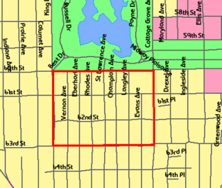
The Washington Park Subdivision is the name of the historic 3-city block by 4-city block subdivision in the northwest corner of the Woodlawn community area, on the South Side of Chicago in Illinois that stands in the place of the original Washington Park Race Track. The area evolved as a redevelopment of the land previously occupied by the racetrack. It was originally an exclusively white neighborhood that included residential housing, amusement parks, and beer gardens.
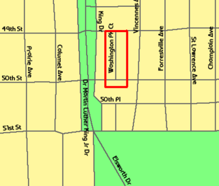
The Washington Park Court District is a Grand Boulevard community area neighborhood on the South Side of Chicago, Illinois. It was designated a Chicago Landmark on October 2, 1991. Despite its name, it is not located within either the Washington Park community area or the Washington Park park, but is one block north of both. The district was named for the Park.

Douglass Park is a part of the Chicago Park District on the West Side of Chicago, Illinois. Established in 1869 and initially named South Park, its 173 acres (0.70 km2) are in the North Lawndale community area with an official address of 1401 S. Sacramento Drive.

The Ukrainian Village District is a landmark-designated district of residential buildings within the West Town community area of Chicago, Illinois. It was designated a Chicago Landmark in 2002, with area extensions in 2005 and 2007.
The Jackson Park Highlands District is a historic district in the South Shore community area of Chicago, Illinois, United States. The district was built in 1905 by various architects. It was designated a Chicago Landmark on October 25, 1989.
Old Edgebrook is a historic district and neighborhood in the Forest Glen community area of Chicago, Illinois, United States.
Waite Park is a neighborhood in the Northeast community in Minneapolis, Minnesota. Its boundaries are 37th Avenue NE to the north, NE Stinson Boulevard to the East, Saint Anthony Parkway to the south, and NE Central Avenue to the west. It is the furthest northeast neighborhood within Minneapolis. It is one of ten neighborhoods in Ward 1 of Minneapolis, currently represented by Council President Elliott Payne, and falls under the jurisdiction of the second precinct of the Minneapolis Police Department.

Indian Village is the small southeast corner of Kenwood, a community area on the South Side of Chicago, Illinois, United States. It is bounded by Lake Shore Drive to the east, Burnham Park to the north, 51st Street to the south, Harold Washington Park to the southeast, and the Illinois Central Railroad tracks used by the South Shore and Metra Electric Lines to the west. Many of the buildings in the neighborhood are named after American Indian tribes including the National Register of Historic Places (NRHP)-designated Narragansett; the Powhatan Apartments, a Chicago Landmark; the Chippewa; and the Algonquin Apartment buildings.

The Martin Drive neighborhood of Milwaukee is a residential district on the west side of the city. It is named for the local 19th-century politician Morgan Lewis Martin. Housing development started in the 1920s around two breweries. The area has benefited from local improvement programs and community activities since the 1990s.
Legends South, formerly Robert Taylor Homes, is a neighborhood located in the Grand Boulevard Community Area on the South side of Chicago, Illinois.

Dearborn Homes is a Chicago Housing Authority (CHA) public housing project located in the Bronzeville neighborhood on the South Side of Chicago, Illinois. It is located along State Street between 27th and 30th Streets, and bounded by the Metra rail line to the west. It is one of only two housing projects that still exist from the State Street Corridor which included other CHA developments: Robert Taylor Homes, Stateway Gardens, Harold Ickes Homes and Hillard Homes.

Harold L. Ickes Homes was a Chicago Housing Authority (CHA) public housing project on the Near South Side of Chicago, Illinois, United States. It was bordered between Cermak Road to the north, 24th Place to the south, State Street to the east, and Federal Street to the west, making it part of the State Street Corridor that included other CHA properties: Robert Taylor Homes, Dearborn Homes, Stateway Gardens and Hilliard Homes.

Dearborn Street is a street in Chicago, where it is 36 W in its grid system. It is the street immediately to the west of State Street, the city's north–south baseline.
