This article's lead sectionmay be too short to adequately summarize the key points. Please consider expanding the lead to provide an accessible overview of all important aspects of the article.(March 2025)
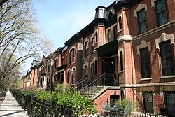
1880s photo in a Lincoln Park neighborhood1934 FBI photograph of the Biograph, soon after the shooting of John Dillinger
In 1824, the United States Army built a small post near today's Clybourn Avenue and Armitage Avenue (formerly Centre Street). Native American settlements existed along Green Bay Trail, now called Clark Street (named after George Rogers Clark), at the current intersection of Halsted Street and Fullerton Avenue. Before Green Bay Trail became Clark Street, it stretched as far as Green Bay, Wisconsin, including Sheridan Road, and was part of what still is Green Bay Road in Milwaukee County, Wisconsin.[2][3]
Federally owned land in what is now Lincoln Park was ceded to the State of Illinois in 1828.[4] In 1837, the same year that Chicago was incorporated as a city, the state granted permission for residents of the Chicago to use the area north of its border at North Avenue for a cemetery.[4][5][6] Later, in response to a cholera epidemic, several more acres were purchased for a hospital and quarantine area.[4] Settlements increased along Green Bay Trail when the government offered land claims and Green Bay Road was widened. The area was incorporated as Lake View Township, which would remain a separate administrative district until being formally annexed by the City of Chicago in 1898.[7] Physicians and citizens complained that having a burial ground in close proximity to a growing residential area was unsanitary. In 1860, they petitioned the Chicago Common Council to repurpose its properties in Lake View as a public park.[4] The sale of burial plots ceased, and small improvements began to be made. In 1865, following the end of the Civil War and the assassination of Abraham Lincoln, the name was changed from "Lake Park" to "Lincoln Park."[4] As with many other Chicago neighborhoods, the name of the park eventually came to refer to the broader area surrounding it.
In the postwar years, the area around Southport and Clybourn became home to a community of Kashubian immigrants. Arriving from what is now north-eastern Poland, Chicago's Kashubians brought their own distinct culture and language, influenced by their rustic traditions, and by their close contact with their German neighbors. In 1882, St. Josaphat'sRoman Catholic parish was established specifically for the Kashubian community. The resulting nicknames of "Jozafatowo" (Polish for "Josaphat's Town") as well as "Kaszubowo" (Polish for "Cassubian Town") made the neighborhood one of Chicago's Polish Patches. The current Romanesque Revival church building was completed in 1902. A Pomeranian Griffin Crest visible on the school south of the church is a nod to the parish that once anchored one of the communities in Chicago dubbed Little Cassubia.
From 1896 to 1903, the original Ferris Wheel was located at a small amusement park near Clark St. and Wrightwood Ave.[8] The site was from 2619 to 2665 N. Clark St., which is now the location of a McDonald's and a high-rise residential building.[9] On February 14, 1929, seven mob associates and a mechanic were shot to death in an automobile garage at 2122 N. Clark St.[10]
During the Great Depression, many buildings in Lincoln Park fell into disrepair.[11] In 1954 the Lincoln Park Conservation Association was founded to prevent deterioration of housing in the neighborhood and by 1956 Lincoln Park received urban renewal funds to renovate and restore old buildings and schools.[12]
I pointed out that it was in the best interests of the City to have us in Lincoln Park ten miles away from the Convention hall. I said we had no intention of marching on the Convention hall, that I didn't particularly think that politics in America could be changed by marches and rallies, that what we were presenting was an alternative life style, and we hoped that people of Chicago would come up, and mingle in Lincoln Park and see what we were about.
Amidst the confrontation, the Church of Our Saviour opened its doors to provide shelter to young people fleeing the violence,[15] beginning a decades long tradition of services that would eventually see the creation of Care for Friends as a nonprofit organization who opened a separate community center behind the church building in 2025.[16]
In the 1950s, 1960s, and 1970s, Lincoln Park became home to the first Puerto Rican immigrants to Chicago. Jose Cha Cha Jimenez transformed the local Young Lords gang into human rights activists for Latinos and the poor.[17] They published newspapers,[18] mounted sit-ins and takeovers of institutions and churches at Grant Hospital, Armitage Ave. Methodist Church, and McCormick Theological Seminary.[12] In 1969, members of the Puerto Rican Young Lords and residents and activists mounted gigantic demonstrations and protested the displacement of Puerto Ricans and the poor including the demolition of buildings on the corner of Halsted and Armitage streets, by occupying the space and some administration buildings at McCormick Theological Seminary.[19] There were civil rights arrests and martyrs including the unsolved murders of United Methodist Rev. Bruce Johnson and his wife Eugenia Ransier Johnson who were strong supporters of the poor. Today their history is archived at DePaul University's Richardson Library and at Special Collections at Grand Valley State University.
On June 29, 2003, a porch collapse occurred during a party at 713 W. Wrightwood Ave. The disaster was the deadliest porch collapse in U.S. history; 13 people were killed and 57 seriously injured.
It encompasses a number of neighborhoods, including Lincoln Central, Mid-North, Old Town Triangle, Park West, RANCH Triangle, Sheffield, and Wrightwood Neighbors. The area also includes most of the Clybourn Corridor retail district, which continues into the Near North Side.
A. Finkl & Sons Steel operated on the west side of Lincoln park along an approximately 22-acre lot by the Chicago River for 113 years. It is now the site of the planned Foundry Park residential community project.
Lincoln Park, for which the neighborhood was named, now stretches miles past the neighborhood of Lincoln Park. The park lies along the lakefront from Ohio Street Beach in the Streeterville neighborhood, northward to Ardmore Avenue in Edgewater. The section of the park adjacent to the Lincoln Park neighborhood contains Lincoln Park Zoo, Lincoln Park Conservatory, an outdoor theatre, a rowing canal, the Chicago History Museum, the Peggy Notebaert Nature Museum, the Alfred Caldwell Lily Pool, the North Pond Nature Sanctuary, North Avenue Beach, playing fields, a very prominent statue of General Ulysses S. Grant, as well as a famous statue of Abraham Lincoln (and many other statues).[29]
The YMCA opened the New City YMCA in 1981.[30] The YMCA's clientele included people in Lincoln Park and in Cabrini-Green.[31] As the YMCA was located in the latter, it was built windowless so it would not suffer from stray bullets, a product of crime in that neighborhood.[30]CBS Chicago 2 stated that the facility was "once credited with breaking down a barrier between families from" different socioeconomic communities.[32] In 2007, the YMCA closed, with the land sold, as Cabrini Green's impoverished community moved away. The YMCA shifted its focus and planned to open a new facility in Kelly Hall of the Mission of Our Lady of the Angels in Humboldt Park.[30]
Most of Lincoln Park is currently part of the 43rd ward of the Chicago City Council, represented by Timmy Knudsen. The extreme south and extreme western sections of the neighborhood are part of the 2nd and 32nd wards, represented respectively by Brian Hopkins and Scott Waguespack. All three aldermen are Democrats.
State
In the Illinois House of Representatives, the lakefront portion of the neighborhood is part of the 12th district, represented by Margaret Croke. Central Lincoln Park is part of Ann Williams' 11th District, and the riverside portion of the neighborhood is represented by Jaime Andrade in the 40th district. The Sheffield Neighbors area is part of Jawaharial Williams's 10th district, and a small southern portion of the neighborhood is represented by Lakesia Collins. All representatives are Democrats.
Additionally, two zoned elementary schools (grades K–8), Abraham Lincoln Elementary School[36] and Louisa May Alcott School.[37] are found in the neighborhood. LaSalle Language Academy, Oscar Mayer Elementary School,[38] and the Newberry Math and Science Academy, all magnet schools, serve the neighborhood.
Melanie Ann Apel, author of Lincoln Park, Chicago, described Lincoln School as "the school most often associated with Lincoln Park".[39]
J. J. Bittenbinder (1942–2023), police officer, television host, and author. He was a childhood resident of the DePaul neighborhood in Lincoln Park.[42]
Roger Brown, an important Chicago Imagist painter, lived at 1926 N. Halsted St. The house is now site to the Art Institute of Chicago's Roger Brown study center.[43]
↑Lyon, Jeff (May 2, 1993). "The J.J. Bittenbinder Show: From church basements to TV, a Chicago cop gets top billing with his tips on stayin' alive". Chicago Tribune. p.SM22. growing up in the DePaul neighborhood
This page is based on this Wikipedia article Text is available under the CC BY-SA 4.0 license; additional terms may apply. Images, videos and audio are available under their respective licenses.