East Garfield Park, Chicago

Last updated

East Garfield Park
Community Area 27 - East Garfield Park
Garfield Pk Fieldhouse, Chicago 1.JPG
The Garfield Park fieldhouse
US-IL-Chicago-CA27.svg
Location within the city of Chicago
Coordinates: 41°52.8′N87°42′W / 41.8800°N 87.700°W / 41.8800; -87.700
CountryUnited States
StateIllinois
County Cook
CityChicago
Neighborhoods
Area
  Total1.94 sq mi (5.02 km2)
Population
 (2020)
  Total19,992 [1]
Demographics 2020 [1]
   White 5.9%
  Black84.9%
  Hispanic4.8%
  Asian0.9%
  Other3.5%
Educational Attainment 2020 [1]
  High School Diploma or Higher79.2%
  Bachelor's Degree or Higher18.8%
Time zone UTC-6 (CST)
  Summer (DST) UTC-5 (CDT)
ZIP Codes
parts of 60612 and 60624
Median household income (2020) [1] $23,067
Source: U.S. Census, Record Information Services

East Garfield Park is a high crime neighborhood on the West Side of Chicago, Illinois, west of the Loop.

Contents

Taking its name from the large urban park, Garfield Park, the neighborhood is bordered by Franklin Boulevard on the north, Arthington and Taylor Streets on the south, Hamlin Avenue and Independence Boulevard to the west, and Rockwell Street to the east.

History

Before Non-Native Settlement

East Garfield Park, along with all of Chicago, lies on the ancestral lands of indigenous tribes, including the Council of Three Fires—comprising the Ojibwe, Odawa and Potawatomi Nations—and the Miami, Ho-Chunk, Menominee, Sac, Fox, Kickapoo and Illinois Nations. [2] On May 28, 1830, President Andrew Jackson signed the Indian Removal Act which forced the area's indigenous tribes to relocate west of the Mississippi River. [3]

Early Development

The East Garfield Park community was undeveloped prairie and farmland until the late 1860s, with residential growth in the area curtailed by limited transportation facilities and few public improvements to the area. [4]

In 1869, the area became part of Chicago when the land from current-day Western Avenue to Pulaski Road and from North Avenue to about 39th Street was annexed to the city by the state legislature. [5]

At the same time, the state legislature created three West Side parks, including a vast, 182-acre tract in the northwestern corner of the community, [4] designated Central Park and later renamed to Garfield Park in 1885 to honor slain president James Garfield. [6]

Land speculators invested in the land adjacent to the park, and the horse-drawn car line on Madison Street was extended to the park. [4] Wealthy Chicagoans, attracted by the park, built their homes along Washington Boulevard as well as in a small tract located between Kedzie and Central Park Avenue, Jackson Boulevard and Madison Street. [6]

Despite this momentum, it was not until the period from 1885 to 1914 that the community developed more rapidly. Triggers for growth included the completion of the Lake Street and Garfield Park branches of the elevated line and the electrification of the surface lines. In addition, industrial areas developed along the northern, eastern and southern borders where railroad tracks of many of the major rail lines of the time were located. Factories and warehouses were attracted to the area by the readily accessible rail transportation, lower land values and lower taxes. Workers were drawn to the area by the increase in economic activity and settled in the community. [4]

Neighborhood Expansion

By 1900, East Garfield Park was a growing residential community, with first and second generation Irish and some Germans living in brick cottages, two-flats and older frame structures. [4] The housing built throughout the community represented a lesson well-learned from the 1871 Chicago Fire as brick and stone structures predominated. [6]

In 1905, Sears, Roebuck built a 55-acre complex near the community's southern section in neighboring North Lawndale, resulting in employment opportunities for East Garfield Park residents, increased land values and community stability. [6]

By 1920, the neighborhood had 56,269 residents with Russian Jews and Italians joining the early Irish and German residents. By the 1930s, Italians displaced the Irish and became the largest ethnic group in the area, with the Russian Jews being the third largest group. Black residents, constituting 3 percent of the population at the time, were concentrated in the northwestern corner of the community. [4]

In the 1920s, a prosperous commercial strip on Madison Street, anchored at Kedzie Avenue, emerged and provided a generation or more of residents with goods and services until competition from a regional shopping center at Madison and Pulaski Road drew customers away. [6]

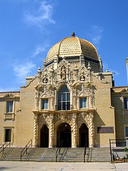
In 1923, the Graemere Hotel opened in East Garfield Park. Located on the northeast corner of Homan Avenue and Washington Boulevard, across from Garfield Park, the building was designed by Walter W. Ahlschlager. The hotel soon became a favorite venue for weddings, bar mitzvahs, and other social gatherings. Wealthy people who enjoyed the convenience of hotel living became permanent residents. The most prominent of these was longtime West Side congressman Adolph Sabath. [7]

In a pattern common to many other areas, however, the growth in the community and other factors led some of the area's most affluent and some of its middle class residents to move to the suburbs, such as Oak Park and Maywood on the city's western boundary. [6] A dip in the population was noticeable after 1930 as the total of 63,000 decreased to 58,000 in 1934. [6]

By 1940, overcrowded, substandard housing, along with increased social problems, typified community life. Vice, crime, juvenile delinquency and gangs increased, challenging social service agencies such as Marillac House and the Sears YMCA. [6]

Post-World War II

Following World War II, East Garfield Park experienced further declines in growth. Older housing stock deteriorated and neighborhood residents were displaced due to the construction of the Congress Street (now Eisenhower) Expressway. [5] The expressway passes east and west through the southern portion of the community. [4]

As industry depended less on rail service and more on truck transportation using the new expressways, many companies moved out of the city. In East Garfield Park, this trend was reflected in the gradual disappearance of the neighborhood's warehouse and manufacturing buildings. [5] Industrial activities within East Garfield Park declined despite the presence of a large working class population, reflecting business choices to relocate where lower costs made operations more profitable. [6]

In the 1950s, public housing adjacent to and just north of the Expressway was constructed in East Garfield Park by the Chicago Housing Authority including Harrison Courts, built from 1950–52; Maplewood Courts, built from 1950–52; and Rockwell Gardens, a fifteen-acre project built from 1954-1961. [5]

African Americans had been leaving their homes in the south since the turn of the century and by mid-century, their numbers had dramatically changed Chicago's demographic data; East Garfield Park was no exception to that transformation. [8] By 1960, East Garfield Park demographics had changed considerably from earlier years, with black residents constituting 62 percent of the population. [6] New Mexican and Puerto Rican immigrants had also joined the neighborhood, although the Italians remained the largest immigrant population in the area. [6]

In 1968, rioting in the aftermath of Martin Luther King, Jr.'s assassination destroyed almost all of the businesses along Madison as well as the area's commercial vitality. [6] The city's main answer to the neighborhood's decline was to demolish scores of blighted buildings in a bid to improve public safety. [9]

By 1970, East Garfield Park suffered from stagnation and apathy. The commercial base of the community waned and the all-important Merchant's Bank at Kedzie and Madison closed, leaving only a small bank supported by area employer Sears at the community area's southern end. [6] In 1973, Sears moved to the Sears Tower and most of the North Lawndale facility was vacated. [10] In 1978, the once beautiful and busy Graemere Hotel located in the East Garfield Park community was torn down. [11]

Community spirit rose quickly after the 1983 mayoral election and aldermanic elections brought increased community participation in its wake. A demand for improved city services accompanied more citizen involvement, led by community groups and block clubs. Especially active were the Midwest Community Council and Fifth City Development Project. [6]

More recently, the future of East Garfield Park is uncertain. The stagnation of yesteryear is apparent despite a strong working class core which has remained in place and active in churches and a confederation of block clubs. [6] But efforts to reinvent and energize the community continue. In 2018, the community's chamber of commerce drafted a plan to reimagine Madison Street, filled with architectural renderings of shops — a coffeehouse, a grocery store, a hardware shop — with residences above them. [9] As yet, the plan has not been implemented. Due to its many positive attributes, the neighborhood is a likely gentrification target for real estate developers, but the neighborhood is proactively developing plans to stave off the displacement that has fractured other communities across Chicago. [12]

Demographics

Historical Population
CensusPop.Note
1930 63,353
1940 65,7893.8%
1950 70,0916.5%
1960 66,871−4.6%
1970 52,005−22.2%
1980 31,580−39.3%
1990 24,030−23.9%
2000 20,881−13.1%
2010 20,567−1.5%
2020 19,992−2.8%
Sources: 1930–2020 [13] [1]

According to a 2022 Chicago Metropolitan Agency for Planning report citing 2020 data, there were 19,992 people and 7,828 households residing in the area. [1]

The racial makeup of the area was 5.90% White, 84.90% African American, 0.90% Asian, 3.50% from other races. Hispanic or Latino of any race were 4.80% of the population. [1]

Age distribution for the area is similar to other nearby communities, with 29.40% under the age of 19, 23.90% from 20 to 34, 19.20% from 35 to 49, 16.50% from 50 to 64, and 11.00% who were 65 years of age or older. The median age was 32.4, [1] just below the Chicago median age, which was 34.8.

The median household income for the area was $23,067 as opposed to $62,097 for the city. The area's residents were disproportionately lower income with 52.0% of residents earned less than $25,000, 21.8% of residents earned between $25,000 and $49,999, 9.8% earned between $50,000 and $74,999, 5.4% earned between $75,000 and $99,999, 6.6% earned between $100,000 and $149,999, 4.4% earned $150,000 or more.

There were 7,447 residents in the labor force. In 2019, 18.4% of workers were employed in the healthcare industry, 10.0% were employed in retail, 12.5% were employed in administration, 8.9% worked in education, and 9.7% worked in hospitality and food services. The area had an unemployment rate of 19.0% during the analysis period. [1]

Arts and culture

Nearly 20% of the neighborhood is managed by the Chicago Park District, with Garfield Park occupying the northwest corner of the neighborhood. The neighborhood is home to the Garfield Park Conservatory, one of the largest conservatories in the United States.

Government

The East Garfield Park community area has supported the Democratic Party in the past two presidential elections by overwhelming margins. In the 2016 presidential election, the East Garfield Park cast 6,690 votes for Hillary Clinton and cast 141 votes for Donald Trump (96.22% to 2.03%). [14] In the 2012 presidential election, East Garfield Park cast 9,046 votes for Barack Obama and cast 100 votes for Mitt Romney (98.51% to 1.09%). [15]

Education

Chicago Public Schools operates district public schools.

Laura Ward Elementary School is in Humboldt Park. [16] The building was formerly the Martin Ryerson Elementary School. Ryerson School closed in 2013, [17] and Laura Ward, previously in an East Garfield Park building, [18] was moved to the former Ryerson building, which became the new Ward Elementary building; both school populations merged into one. [17] There were members of the Ryerson community who were afraid that the Ward community would cause violent incidents at their school. [18]

In addition Urban Prep Academies operates the East Garfield Park Campus. [19] Providence St. Mel School, a private school, is in East Garfield Park. [20]

Infrastructure

Transportation

Two of Chicago Transit Authority's train lines, the Blue Line and the Green Line, serves this neighborhood. The Green Line has stations at California, Kedzie, and Central Park Drive. The Blue Line has a station in the neighborhood in the median of the Eisenhower Expressway, Kedzie-Homan.

The neighborhood is also served by the CTA's bus service. East-west bus routes include 20 along Madison Street, 126 along Jackson Street, and 7 along Harrison Street. North-south bus routes include 94 along California Avenue, 52 along Kedzie Avenue, and 82 along Homan Avenue.

Notable people

See also

Related Research Articles

<span class="mw-page-title-main">Hazel Crest, Illinois</span> Village in Illinois, United States

Hazel Crest is a village in Cook County, Illinois, United States. The population was 13,382 at the 2020 census.

<span class="mw-page-title-main">Rogers Park, Chicago</span> Community area in the United States

Rogers Park is the first of Chicago's 77 community areas. Located 9 miles (14 km) from the Loop, it is on the city's far north side on the shore of Lake Michigan. The neighborhood is culturally diverse and features green spaces, early 20th century architecture, live theater, bars, restaurants, and beaches. It is bounded by the city of Evanston along Juneway Terrace and Howard Street to the north, Ridge Boulevard to the west, Devon Avenue and the Edgewater neighborhood to the south, and Lake Michigan to the east. The neighborhood just to the west, West Ridge, was part of Rogers Park until the 1890s and is still sometimes referred to as West Rogers Park. In the early 1900s, what is now Loyola University Chicago became established at the south eastern end of the community area along the lake.

<span class="mw-page-title-main">Albany Park, Chicago</span> Community area in Chicago

Albany Park is one of 77 well-defined community areas of Chicago. Located on the Northwest Side of the City of Chicago with the North Branch of the Chicago River forming its east and north boundaries, it includes the ethnically diverse Albany Park neighborhood, with one of the highest percentages of foreign-born residents of any Chicago neighborhood.

<span class="mw-page-title-main">Humboldt Park, Chicago</span> Community area in Chicago

Humboldt Park, one of 77 designated community areas, is on the West Side of Chicago, Illinois. The Humboldt Park neighborhood is known for its dynamic social and ethnic demographic change over the years. The Puerto Rican community has identified strongly with the area since the 1970s. Humboldt Park is also the name of a 207-acre (0.8 km2) park adjacent to the community area.

<span class="mw-page-title-main">Austin, Chicago</span> Community area in Chicago

Austin is one of 77 community areas in Chicago. Located on the city's West Side, it is the third largest community area by population and the second-largest geographically. Austin's eastern boundary is the Belt Railway located just east of Cicero Avenue. Its northernmost border is the Milwaukee District / West Line. Its southernmost border is at Roosevelt Road from the Belt Railway west to Austin Boulevard. The northernmost portion, north of North Avenue, extends west to Harlem Avenue, abutting Elmwood Park. In addition to Elmwood Park, Austin also borders the suburbs of Cicero and Oak Park.

<span class="mw-page-title-main">Logan Square, Chicago</span> Community area in Chicago

Logan Square is an official community area, historical neighborhood, and public square on the northwest side of the City of Chicago. The Logan Square community area is one of the 77 city-designated community areas established for planning purposes. The Logan Square neighborhood, located within the Logan Square community area, is centered on the public square that serves as its namesake, located at the three-way intersection of Milwaukee Avenue, Logan Boulevard and Kedzie Boulevard.

<span class="mw-page-title-main">Irving Park, Chicago</span> Community area in Chicago

Irving Park is one of 77 officially designated Chicago community areas, and is located on the Northwest Side. It is bounded by the Chicago River on the east, the Milwaukee Road railroad tracks on the west, Addison Street on the south and Montrose Avenue on the north, west of Pulaski Road stretching to encompass the region between Belmont Avenue on the south and, roughly, Leland Avenue on the north. It is named after the American author Washington Irving.

<span class="mw-page-title-main">Armour Square, Chicago</span> Community area in Illinois, United States

Armour Square is a Chicago neighborhood on the city's South Side, as well as a larger, officially defined community area, which also includes Chinatown and the CHA Wentworth Gardens housing project. Armour Square is bordered by Bridgeport to the west, Pilsen to the northwest, Douglas and Grand Boulevard to the east and southeast, and with the Near South Side bordering the area to the north, and Fuller Park bordering its southernmost boundary, along Pershing Road.

<span class="mw-page-title-main">Ashburn, Chicago</span> Community area in Chicago

Ashburn, one of Chicago's 77 community areas, is located on the south side of the city. Greater Ashburn covers nearly five square miles. The approximate boundaries of Ashburn are 72nd Street (north), Western Avenue (east), 87th Street (south) and Cicero Avenue (west).

<span class="mw-page-title-main">Near West Side, Chicago</span> Community area in Chicago

The Near West Side, one of the 77 community areas of Chicago, is on the West Side, west of the Chicago River and adjacent to the Loop. The Great Chicago Fire of 1871 started on the Near West Side. Waves of immigration shaped the history of the Near West Side of Chicago, including the founding of Hull House, a prominent settlement house. In the 19th century railroads became prominent features. In the mid-20th century, the area saw the development of freeways centered in the Jane Byrne Interchange.

<span class="mw-page-title-main">West Ridge, Chicago</span> Community area in Chicago

West Ridge is one of 77 Chicago community areas. It is a middle-class neighborhood located on the far North Side of the City of Chicago. It is located in the 50th ward and the 40th ward.

<span class="mw-page-title-main">West Town, Chicago</span> Community area in Chicago

West Town, northwest of the Loop on Chicago's West Side, is one of the city's officially designated community areas. Much of this area was historically part of Polish Downtown, along Western Avenue, which was then the city's western boundary. West Town was a collection of several distinct neighborhoods and the most populous community area until it was surpassed by Near West Side in the 1960s. The boundaries of the community area are the Chicago River to the east, the Union Pacific railroad tracks to the south, the former railroad tracks on Bloomingdale Avenue to the North, and an irregular western border to the west that includes the city park called Humboldt Park. Humboldt Park is also the name of the community area to West Town's west, Logan Square is to the north, Near North Side to the east, and Near West Side to the south. The collection of neighborhoods in West Town along with the neighborhoods of Bucktown and the eastern portion of Logan Square have been referred to by some media as the "Near Northwest Side".

<span class="mw-page-title-main">West Garfield Park, Chicago</span> Community area in Chicago

West Garfield Park on the West Side of Chicago, Illinois, is one of 77 officially designated Chicago community areas. It is directly west of Garfield Park.

<span class="mw-page-title-main">North Lawndale, Chicago</span> Community area in Chicago

North Lawndale is one of the 77 community areas of the city of Chicago, Illinois, located on its West Side. The area contains the K-Town Historic District, the Foundation for Homan Square, the Homan Square interrogation facility, and the greatest concentration of greystones in the city. In 1968, Rev. Dr. Martin Luther King Jr. stayed in an apartment in North Lawndale to highlight the dire conditions in the area and used the experience to pave the way to the Fair Housing Act.

<span class="mw-page-title-main">Lower West Side, Chicago</span> Community area in Chicago, Illinois, United States

Lower West Side is a community area on the West Side of Chicago, Illinois, United States. It is three miles southwest of the Chicago Loop and its main neighborhood is Pilsen. The Heart of Chicago is a neighborhood in the southwest corner of the Lower West Side.

Kedzie Avenue is a major north–south street in Chicago, Illinois.

<span class="mw-page-title-main">Pershing Road (Chicago)</span>

Pershing Road is an east-west street on the south side of Chicago and in its immediate western suburbs in Cook County, Illinois. It is precisely four miles south of Madison Street, the division point between north and south street numbering, and marks the 3900 South point in the region's street numbering system. Its western segment, more commonly referred to as 39th Street, runs east from a U.S. Route 34 in Lyons to Illinois Route 50 in Cicero. Its eastern segment, officially known as Pershing Road, runs east from a cul-de-sac at 3600 West to Oakwood Boulevard, which continues east ending at U.S. Route 41. All of the eastern segment lies within the city of Chicago.

<span class="mw-page-title-main">Garfield Boulevard</span>

Garfield Boulevard is an east-west street on the south side of Chicago and its immediate western suburbs. Its western segment, entirely known as 55th Street, runs east from Maple Avenue in Downers Grove until it becomes Joliet Road in Countryside. Its eastern segment, known only as Garfield Boulevard from Western Avenue in Gage Park to Elsworth Drive in Washington Park, runs east from Archer Avenue and Narragansett Avenue to South Shore Drive, just west of U.S. Route 41. All of the eastern segment of 55th Street lies within the city limits of Chicago.

<span class="mw-page-title-main">West Side, Chicago</span> District in Illinois, United States

The West Side is one of the three major sections of the city of Chicago, Illinois, United States. It is joined by the North and South Sides. The West Side contains communities that are of historical and cultural importance to the history and development of Chicago. On the flag of Chicago, the West Side is represented by the central white stripe.

There are several neighborhoods in the city of Pasadena, California

References

  1. 1 2 3 4 5 6 7 8 9 "Community Data Snapshot - East Garfield Park" (PDF). cmap.illinois.gov. MetroPulse. Retrieved February 28, 2023.
  2. "Indigenous Tribes of Chicago". American Library Association. Retrieved July 6, 2023.
  3. "Indian Removal Act: Primary Documents of Americas History". Library of Congress. Retrieved July 6, 2023.
  4. 1 2 3 4 5 6 7 Kitagawa, Evelyn M.; Taeuber, Karl E. (1963). Local Community Fact Book, Chicago metropolitan area, 1960. Chicago, Il: Chicago Review Press. p. 100.
  5. 1 2 3 4 "Landmark Designation Report, Lindemann & Hoverson Co. Showroom & Warehouse Building" (PDF). Chicago Department of Housing and Economic Development. 2008. Archived from the original on July 26, 2011. Retrieved April 8, 2023.
  6. 1 2 3 4 5 6 7 8 9 10 11 12 13 14 15 Erbe, William; Montgomery, Andrew; Reed, Christopher (1963). Local Community Fact Book, Chicago metropolitan area, 1990. Chicago, Il: Chicago Review Press. p. 100.
  7. "Graemere Hotel". John R. Schmidt. Archived from the original on July 29, 2017. Retrieved April 8, 2023.
  8. "Reaching Out And Revolutionizing Race Relations, 1955-1964". Marillac St. Vincent Family Services. Archived from the original on August 29, 2022. Retrieved April 8, 2023.
  9. 1 2 "Disinvested: How Government and Private Industry Let the Main Street of a Black Neighborhood Crumble". ProPublica. Archived from the original on April 7, 2023. Retrieved April 8, 2023.
  10. "Sears, Roebuck & Co.'s Former West Side Headquarters Confirmed as Landmark District". City of Chicago. Archived from the original on May 17, 2019. Retrieved May 17, 2019.
  11. Cutler, Irving (October 26, 2009). "Chapter 2 - Institutions and Residences". Chicago's Jewish West Side. Charleston, South Carolina: Arcadia Publishing. ISBN   9781439621004 . Retrieved November 30, 2020.
  12. "With East Garfield Park Ripe For Gentrification, Residents Draw Up Blueprint To Protect Themselves". Blockclub. Archived from the original on March 12, 2023. Retrieved April 8, 2023.
  13. Paral, Rob. "Chicago Community Areas Historical Data". Archived from the original on March 18, 2013. Retrieved September 3, 2012.
  14. Ali, Tanveer (November 9, 2016). "How Every Chicago Neighborhood Voted In The 2016 Presidential Election". DNAInfo . Archived from the original on September 24, 2019. Retrieved October 4, 2019.
  15. Ali, Tanveer (November 9, 2012). "How Every Chicago Neighborhood Voted In The 2012 Presidential Election". DNAInfo . Archived from the original on February 3, 2019. Retrieved October 4, 2019.
  16. "Laura Ward Elementary School". Communities of Schools in Chicago. Retrieved January 13, 2024.
  17. 1 2 "Providing A Better Education For All Students Ryerson Elementary and Ward, L Elementary". Chicago Public Schools. Retrieved January 12, 2024.
  18. 1 2 "Parents unwelcoming of school move". ABC 7 Chicago. March 22, 2013. Retrieved January 12, 2024.
  19. "East Garfield Park." Urban Prep Academies. Retrieved on December 10, 2010.
  20. "Contact Archived 2012-11-01 at the Wayback Machine ." Providence St. Mel School. Retrieved on April 16, 2011. "Providence St. Mel 119 South Central Park Avenue Chicago, Illinois 60624"
  21. Shaheen, AJ (November 21, 2019). "Lupe Fiasco at The Riviera". WNUR-FM . Retrieved June 29, 2023.
  22. Thompson, John (May 7, 1944). "'D' DAY WILL FIND CHICAGO FLYERS ON GUARD IN AIR: They'll Be Blasting Foe from Their Marauders". Chicago Daily Tribune .
  23. Thomas, Isiah (May 26, 2019). "Pop A Cork With Isiah Thomas!". N'Digo (Interview). Interviewed by Hermene Hartman. Chicago: Hartman Publishing. Retrieved November 25, 2020.