New City Back of the Yards/Canaryville | |
---|---|
Community Area 61—New City | |
Coordinates: 41°48.6′N87°39.6′W / 41.8100°N 87.6600°W | |
Country | United States |
State | Illinois |
County | Cook |
City | Chicago |
Neighborhoods | List
|
Area | |
• Total | 4.86 sq mi (12.59 km2) |
Population (2020) [1] | |
• Total | 43,628 |
• Density | 9,000/sq mi (3,500/km2) |
Demographics 2020 [1] | |
• White | 12.4% |
• Black | 23.1% |
• Hispanic | 61.8% |
• Asian | 1.9% |
• Other | 0.8% |
Time zone | UTC−6 (CST) |
• Summer (DST) | UTC−5 (CDT) |
ZIP Code | part of 60609 |
Median income 2020 [1] | $35,396 |
Source: U.S. Census, Record Information Services |
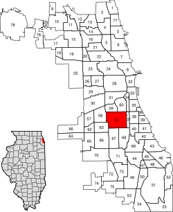
New City is one of Chicago's 77 official community areas, located on the southwest side of the city in the South Side district. It contains the neighborhoods of Canaryville and Back of the Yards.
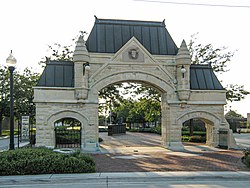
The area was home to the famous Union Stock Yards from 1865 until it closed in 1971, and the International Amphitheatre from 1934 until it was demolished in 1999.
Census | Pop. | Note | %± |
---|---|---|---|
1930 | 87,103 | — | |
1940 | 80,725 | −7.3% | |
1950 | 75,917 | −6.0% | |
1960 | 67,428 | −11.2% | |
1970 | 60,747 | −9.9% | |
1980 | 55,860 | −8.0% | |
1990 | 53,226 | −4.7% | |
2000 | 51,721 | −2.8% | |
2010 | 44,377 | −14.2% | |
2020 | 43,628 | −1.7% | |
[1] [2] |
Back of the Yards is an industrial and residential neighborhood so named because it was near the former Union Stock Yards, which employed thousands of European immigrants in the early 20th century. Life in this neighborhood was explored in Upton Sinclair's 1906 novel The Jungle . The area was formerly part of the town of Lake until it was annexed by Chicago in 1889. In the late 19th and early 20th centuries, the area was occupied largely by Eastern European immigrants and their descendants, who were predominantly ethnic Lithuanian, Bohemian, Moravian, and Slovak. [3]
In 1939, the activist Saul Alinsky and the local park director Joseph Meegan organized the Back of the Yards Neighborhood Council, where Alinsky first developed the method of community organizing. The prerequisites of this successful attempt to bring together community leaders from different national Catholic churches, business, and labor were the Great Depression and the labor organizing work of the Packinghouse Workers Organizing Committee, a member of the CIO led in Chicago by Herb March. This work led to his founding the Industrial Areas Foundation in 1940, which later trained community organizers. [4]
Jane Jacobs, in her 1961 book The Death and Life of Great American Cities , cites the Back of the Yards as an area able to "unslum" in the 1960s, due to a beneficial set of circumstances. This included a stabilized community base with skilled members who were willing to trade work to upgrade housing, as well as active and well-led local social and political organizations. Jacobs often cited the Back of the Yards as a model for other depressed neighborhoods to follow to upgrade their communities. [5]
Some time after the 1970s, when the stockyard operations closed and the number of nearby jobs decreased, many people left to move to newer housing and work in the suburbs. The population of the neighborhood gradually reflected a new wave of settlement, predominantly Mexican-American.
The Canaryville neighborhood is one of the oldest neighborhoods in Chicago, and borders the Bridgeport neighborhood. According to the Encyclopedia of Chicago , the neighborhood extends from Pershing Road to 49th Street and centers on Halsted Street. The area's residents experienced the development, and then decline, of the meat packing industry, when Chicago was, in the words of Carl Sandburg, "hog butcher for the world". Many of its residents found other work in the post–World War II years.
Historically, Canaryville was a largely Irish American neighborhood, starting Irish immigrants escaping the Great Famine in the mid-19th century. They were deeply entrenched in the neighborhood, considering it their territory, and attempted to defend it against later arrivals of all races –including non-Irish White, Black, Hispanic, and Asian people. Its Irish gangs were active in attacks on Black people in the Chicago Race Riot of 1919. Since the late 20th century, Latin American (predominantly Mexican) immigrants and their descendants have moved into the area. [6] Canaryville is now largely both Irish and Mexican.
Canaryville's name may refer to the sparrows who fed in the stockyards and railroad cars in the late 1800s. The name may also refer to white youth gangs in the neighborhood from the early 1900s, who were known as "wild canaries". [6]
The New City community area supported the Democratic Party in the 2012 and 2016 presidential elections. In 2016, New City cast 8,897 votes for Hillary Clinton and 1,331 votes for Donald Trump (84.40% to 12.63%). [7] In 2012, New City cast 9,053 votes for Barack Obama and 1,009 votes for Mitt Romney (89.36% to 9.96%). [8]
Saul David Alinsky was an American community activist and political theorist. His work through the Chicago-based Industrial Areas Foundation helping poor communities organize to press demands upon landlords, politicians, bankers and business leaders won him national recognition and notoriety. Responding to the impatience of a New Left generation of activists in the 1960s, Alinsky – in his widely cited Rules for Radicals: A Pragmatic Primer (1971) – defended the arts both of confrontation and of compromise involved in community organizing as keys to the struggle for social justice.
Bridgeport is one of the 77 community areas in Chicago, on the city's South Side, bounded on the north by the South Branch of the Chicago River, on the west by Bubbly Creek, on the south by Pershing Road, and on the east by the Union Pacific railroad tracks. Neighboring communities are Pilsen across the river to the north, McKinley Park to the west, Canaryville to the south, and Armour Square to the east. Bridgeport has been the home of five Chicago mayors. Once known for its racial intolerance, Bridgeport today ranks as one of the city's most diverse neighborhoods.
Thomas A. Gaudette (1923–1998) was a community organizer who worked in the Austin neighborhood of Chicago. Originally a businessman, Gaudette became interested in neighborhood organizing through his Catholic Church activism. Gaudette helped form a neighborhood group, along the lines of those organized by Saul Alinsky, on the far West Side of Chicago called Organization for a Better Austin. OBA was concerned with poor schools and neighborhood decline.
Norwood Park is one of the 77 Chicago community areas. It encompasses the smaller neighborhoods of Big Oaks, Norwood Park East, Norwood Park West, Old Norwood Park, Oriole Park, and Union Ridge.
Gage Park is one of Chicago's 77 well-defined community areas, located on the city's southwest side; it is also the name of a park within the neighborhood. Gage Park's population is largely working-class, and its housing stock is mostly bungalows. For generations, the neighborhood was Eastern European and Irish Catholic. The neighborhood remains overwhelmingly Catholic with the addition of many Hispanic residents. Gage Park is bounded by 49th Street to the north, 59th Street to the south, Central Park Ave to the west, and Leavitt Street to the east.
Belmont Cragin is one of 77 officially designated Chicago community areas located on the Northwest Side of the City of Chicago, Illinois. It is designated Community Area 19, and is located 8 miles (13 km) NW of the Loop. Surrounding community areas include: Portage Park, Hermosa, Austin, Montclare, Dunning.
West Lawn, one of Chicago's 77 official community areas, is located on the southwest side of the city. It is considered to be a "melting pot" of sorts, due to its constant change of races moving in and out of the area, as well as the diversity that exists there. It has a small town atmosphere in the big city. West Lawn is home to many Polish-Americans, Irish-Americans, Mexican-Americans, and other people of Latin American and Eastern European origin.
Armour Square is a Chicago neighborhood on the city's South Side, as well as a larger, officially defined community area, which also includes Chinatown and the CHA Wentworth Gardens housing project. Armour Square is bordered by Bridgeport to the west, Pilsen to the northwest, Douglas and Grand Boulevard to the east and southeast, and with the Near South Side bordering the area to the north, and Fuller Park bordering its southernmost boundary, along Pershing Road.
Mount Greenwood is one of the 77 community areas in Chicago. The 74th numbered area, it is about 14 miles (23 km) southwest of the Loop. It is surrounded by the neighborhoods of Beverly and Morgan Park to the east, the suburb of Evergreen Park to the north, the suburb of Oak Lawn to the west, and the suburbs of Merrionette Park and Alsip to the south. Mount Greenwood is known as the home of many Chicago firefighters, Chicago police officers, and union workers.
Brighton Park is a community area located on the southwest side of Chicago, Illinois. It is number 58 of the 77 community areas of Chicago.
Oakland, located on the South Side of Chicago, Illinois, USA, is one of 77 officially designated Chicago community areas. Bordered by 35th and 43rd Streets, Cottage Grove Avenue and Lake Shore Drive, The Oakland area was constructed between 1872 and 1905. Some of Chicago's great old homes may be seen on Drexel Boulevard. The late 19th-century Monument Baptist Church on Oakwood Blvd. is modeled after Boston's Trinity Church. Oakwood/41st Street Beach in Burnham Park is at 4100 S. Lake Shore Drive. With an area of only 0.6 sq mi Oakland is the smallest community area by area in Chicago.
Fuller Park is the 37th of Chicago's 77 community areas. Located on the city's South Side, it is 5 miles (8.0 km) from the Loop. It is named for a small park also known as Fuller Park within the neighborhood, which is in turn named for Melville Weston Fuller, a Chicago attorney who was the Chief Justice of the United States between 1888 and 1910.
Burnside is one of the 77 community areas in Chicago. The 47th numbered area, it is located on the city's far south side. This area is also called "The Triangle" by locals, as it is bordered by railroad tracks on every side; the Canadian National Railway on the west, the Union Pacific Railroad on the south and the Norfolk Southern Railway on the east. With a population of 2,254 in 2016, it is the least populous of the community areas, as well as the second smallest by area after Oakland.
McKinley Park, one of the 77 official community areas of Chicago, Illinois, is located on the city's southwest side.
Greater Grand Crossing is one of the 77 community areas of Chicago, Illinois. It is located on the city's South Side.
West Elsdon, one of the 77 official community areas, is located on the southwest side of the City of Chicago, Illinois. It is noted as a twin neighborhood of West Lawn. It has a population which includes a mix of dwindling Polish-American residents and increasing Mexican-American residents who currently constitute a clear majority. It has its own association, "West Elsdon Civic Association," which privately organizes the neighborhood. St. Turibius grade school, a Roman Catholic elementary school, located at 57th and Karlov, closed in 2013 and is currently inactive though the building remains and is adjacent to St. Turibius Roman Catholic church. The former Lourdes Roman Catholic girls' high school located from 55th to 56th street from Komensky to Karlov Avenue is now a Chicago Public Schools magnet high school, John Hancock High School.
Clearing, one of the 77 semi-official community areas, is located on the southwest side of the city of Chicago, Illinois. The southern portion of Chicago Midway International Airport is located within this community area.
Chicago Lawn is one of the 77 community areas of Chicago, Illinois. It is located on the southwest side of the city. Its community neighbors include Gage Park, West Englewood, Ashburn, and West Lawn. It is bounded by the CSX and Norfolk Southern Railway tracks on the east, Central Park Avenue on the west, 59th Street on the north, and the Belt Railway of Chicago on the south, and is 13 km (8.1 mi) southwest of the Loop. Local citizens refer to the area as "Marquette Park," after the park in its center.
Auburn Gresham, most commonly referred to simply as Gresham, is one of the 77 official community areas of the city of Chicago, Illinois. It is located on the far south side of the city and was the original location of the South Side Irish Parade before it was relocated to the adjoining Beverly neighborhood immediately southwest. Its residents are mostly African American.
The United Packinghouse Workers of America (UPWA), later the United Packinghouse, Food and Allied Workers, was a labor union that represented workers in the meatpacking industry.