North Center, Chicago

Last updated

North Center
Community Area 05 - North Center
Lane Tech High School clock tower.jpg
The clocktower of Lane Technical College Prep High School, located in the western part of the neighborhood.
US-IL-Chicago-NorthCenter.png
Streetmap
US-IL-Chicago-CA05.svg
Location within the city of Chicago
Coordinates: 41°57′N87°40.8′W / 41.950°N 87.6800°W / 41.950; -87.6800
CountryUnited States
StateIllinois
County Cook
CityChicago
Neighborhoods
Area
  Total2.07 sq mi (5.36 km2)
Population
 (2020)
  Total35,114
  Density17,000/sq mi (6,600/km2)
Demographics 2019 [1]
   White 77.7%
  Black2.1%
  Hispanic11.5%
  Asian4.9%
  Other3.8%
Educational Attainment 2019 [1]
  High School Diploma or Higher95.2%
  Bachelor's Degree or Higher75.8%
Time zone UTC−6 (CST)
  Summer (DST) UTC−5 (CDT)
ZIP Codes
parts of 60613, 60618, 60657
Median household income 2019 [1] $125,033
Source: U.S. Census, Record Information Services

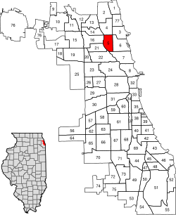
North Center is one of the 77 community areas of Chicago, Illinois, located in the city's North Side. North Center is bordered on the north by Montrose Avenue, on the south by Diversey Parkway, on the west by the Chicago River and on the east by Ravenswood Avenue; it includes the neighborhoods of North Center, Roscoe Village, St. Ben's, and Hamlin Park. The Brown Line of the Chicago 'L' has stops within the community area at Addison, Irving Park, and Montrose.

Contents

Northcenter

The neighborhood known as Northcenter refers to a neighborhood in the North Side of Chicago, Illinois. The boundaries of Northcenter are Addison on the south, Montrose on the north, the Chicago River on the west and Ravenswood (1800 W) on the east. [2] Northcenter has grown since the 1870s when the area was only accessible by the Chicago River and Little Fort Road (now known as Lincoln Avenue). North Center is considered a vibrant neighborhood with an eclectic mix of retailers, restaurants, live music, live theater, and service-oriented businesses. It is also home to some of the best public schools in the City of Chicago. Lane Tech College Prep High School, a top ranked well-rounded and diverse high school in the state; as well as North Park Elementary School, Coonley & Bell Elementary. North Center was voted one of Chicago's best neighborhoods by the Chicago Magazine in 2014. [3]

Northcenter's history is deeply rooted in European cultural influences, from German, Polish, Czech, Romanian, Serbian, Greek, Croatian, French making the majority and that history can be seen in the architectural charm of the homes and buildings from the late 19th and early 20th centuries. Also during this time, the Selig Polyscope Company produced some of America's earliest motion pictures and was based in Chicago. Along Byron Street near Oakley Ave and Western Ave, historic production buildings of the company are still standing and being used as residences and retail businesses. The neighborhood continues to grow and become more culturally diverse. The neighborhood includes bowling alleys, three city parks - including an indoor ice arena, a nearby library, a nearby movie theater complex, and Northcenter Town Square. The Northcenter Chamber of Commerce hosts many free family and community events throughout the year. [4] Northcenter Town Square is also home to a Farmer's Market on Saturdays from June to October.

Roscoe Village

"Welcome to Roscoe Village" Painted Sign on Roscoe at the Train Tracks in 2010 New "Welcome to Roscoe Village" Painted Sign on Roscoe at the Train Tracks.jpg
"Welcome to Roscoe Village" Painted Sign on Roscoe at the Train Tracks in 2010

Roscoe Village refers to a neighborhood in the North Side of Chicago, Illinois. While not part of any official city map, Chicago residents perceive the boundaries of the neighborhood to be Addison Street to the north, Belmont Avenue to the south, Ravenswood Avenue to the east and the Chicago River to the west. [5] The primary feature of Roscoe Village is Roscoe Street, which bisects the neighborhood's boundaries between Addison Street and Belmont Avenue. Roscoe Street is populated by businesses and residents. Local historian and longtime neighborhood resident Chuck Betzold notes that people have been living in Roscoe Village since the 18th century, when the area was inhabited by the Fox Indians. Today[ when? ] the area is home to over 6,200 residents. [6]

From 1904 to 1967, Roscoe Village was home to the "largest amusement park in the world", Riverview Park, a 76-acre (31 ha) amusement park [7] stretching from Belmont Avenue to Lane Tech High School, and from Western Ave. to the Chicago River. Today, the Area 3 Police Headquarters, DePaul College Prep, and Riverview Plaza Center now stand on the space. [8]

St. Ben's

St. Ben's is an unofficial neighborhood with boundaries at Irving Park Road on the north, Addison Street on the south, Damen Avenue on the east, and Western Ave. on the west. It is named for Saint Benedict's Parish, with its Roman Catholic school, on Leavitt Street. [9]

Hamlin Park

The Hamlin Park neighborhood is bounded by Belmont Avenue on the north, Ravenswood Avenue on the east, the Diversey Parkway on the south and the North Branch of the Chicago River on the west. It has its namesake park in the center of the neighborhood. This neighborhood also has the northern half of the Julia C. Lathrop Homes, a CHA housing project.

Historical population
CensusPop.Note
1930 47,651
1940 48,7592.3%
1950 47,787−2.0%
1960 43,877−8.2%
1970 39,378−10.3%
1980 35,161−10.7%
1990 33,010−6.1%
2000 31,895−3.4%
2010 31,867−0.1%
2020 35,11410.2%
[10]

Politics

North Center has reliably supported the Democratic Party in recent years.

Places of interest

Schools

Former places of interest

Notable people

Citations

  1. 1 2 3 "Community Data Snapshot North Center" (PDF). Retrieved August 2, 2021.
  2. "Chicago Neighborhood Details:North Center". Archived from the original on September 4, 2010. Retrieved September 13, 2010.
  3. "North Center Is One of Chicago's 12 Best Neighborhoods" . Retrieved October 7, 2015.
  4. "Home". northcenterchamber.com.
  5. "Roscoe Village Neighbors website". Roscoe Village Neighbors. Retrieved February 17, 2009.
  6. http://censtats.census.gov/data/IL/1601765611.pdf
  7. Kogan, Rick. "Remembering Riverview Park, 50 years later". Chicago Tribune . Retrieved August 26, 2019.
  8. "RIVERVIEW". WTTW Chicago. November 30, 2013. Retrieved August 26, 2019.
  9. www.chicago.com
  10. Paral, Rob. "Chicago Community Areas Historical Data". Archived from the original on March 18, 2013. Retrieved August 30, 2012.
  11. "SLATE 4 HOUR NIGHT PAGEANT FOR M'ARTHUR: Hero Will Be Center of Spectacle". Chicago Tribune . April 25, 1951.
  12. Illinois Blue Book 1965-1966. p. 220. Retrieved January 5, 2024.
  13. Joravsky, Ben (June 25, 1999). "The Grand Old Party's Last Stand". Chicago Reader . Retrieved March 23, 2021.
  14. Malooley, Jake (September 1, 2012). "Steve Wilkos Interview". Time Out Chicago. Retrieved August 15, 2018.

General and cited references

Related Research Articles

<span class="mw-page-title-main">Lake View, Chicago</span> Community area in Chicago

Lakeview, also spelled Lake View, is one of the 77 community areas of Chicago, Illinois. Lakeview is located in the city's North Side. It is bordered by West Diversey Parkway on the south, West Irving Park Road on the north, North Ravenswood Avenue on the west, and the shore of Lake Michigan on the east. The Uptown community area is to Lakeview's north, Lincoln Square to its northwest, North Center to its west, and Lincoln Park to its south. The 2020 population of Lakeview was 103,050 residents, making it the second-largest Chicago community area by population.

<span class="mw-page-title-main">Lincoln Square, Chicago</span> Community area in Chicago

Lincoln Square on the North Side of Chicago, Illinois, is one of the city's 77 community areas. It encompasses the smaller neighborhoods of Ravenswood, Ravenswood Gardens, Bowmanville, Budlong Woods, as well as Lincoln Square itself.

<span class="mw-page-title-main">Albany Park, Chicago</span> Community area in Chicago

Albany Park is one of 77 well-defined community areas of Chicago. Located on the Northwest Side of the City of Chicago with the North Branch of the Chicago River forming its east and north boundaries, it includes the ethnically diverse Albany Park neighborhood, with one of the highest percentages of foreign-born residents of any Chicago neighborhood.

<span class="mw-page-title-main">Lincoln Park</span> Public park in Chicago, Illinois

Lincoln Park is a 1,208-acre (489-hectare) park along Lake Michigan on the North Side of Chicago, Illinois. Named after US President Abraham Lincoln, it is the city's largest public park and stretches for seven miles (11 km) from Grand Avenue, on the south, to near Ardmore Avenue on the north, just north of the DuSable Lake Shore Drive terminus at Hollywood Avenue. Two museums and a zoo are located in the oldest part of the park between North Avenue and Diversey Parkway in the eponymous neighborhood. Further to the north, the park is characterized by parkland, beaches, recreational areas, nature reserves, and harbors. To the south, there is a more narrow strip of beaches east of Lake Shore Drive, almost to downtown. With 20 million visitors per year, Lincoln Park is the second-most-visited city park in the United States, behind Manhattan's Central Park.

<span class="mw-page-title-main">Humboldt Park, Chicago</span> Community area in Chicago

Humboldt Park, one of 77 designated community areas, is on the West Side of Chicago, Illinois. The Humboldt Park neighborhood is known for its dynamic social and ethnic demographic change over the years. The Puerto Rican community has identified strongly with the area since the 1970s. Humboldt Park is also the name of a 207-acre (0.8 km2) park adjacent to the community area.

<span class="mw-page-title-main">Uptown, Chicago</span> Community area in Chicago

Uptown is one of Chicago's 77 community areas. Uptown's boundaries are Foster Avenue to the north; Lake Michigan to the east; Montrose Avenue, and Irving Park Road to the south; Ravenswood Avenue, and Clark Street to the west. To the north is Edgewater, to the west is Lincoln Square, and to the south is Lakeview. Near the lake are some of the northern reaches of Lincoln Park, including Montrose Beach and multiple nature reserves. The area has a mix of commercial and residential development, and includes a well-established entertainment district of clubs and concert venues, and was a center for early film making. Truman College, a two-year city college, is located here, and the area's southwest corner includes the historic 19th century Graceland Cemetery.

<span class="mw-page-title-main">Riverview Park (Chicago)</span> Former amusement park

Riverview Park was an amusement park in Chicago, Illinois, which operated from 1904 to 1967. It was located on 74 acres in an area bound on the south by Belmont Avenue, on the east by Western Avenue, on the north by Lane Tech College Prep High School, and on the west by the North Branch of the Chicago River. It was located in the Roscoe Village neighborhood of Chicago's North Center community area.

<span class="mw-page-title-main">Logan Square, Chicago</span> Community area in Chicago

Logan Square is an official community area, historical neighborhood, and public square on the northwest side of the City of Chicago. The Logan Square community area is one of the 77 city-designated community areas established for planning purposes. The Logan Square neighborhood, located within the Logan Square community area, is centered on the public square that serves as its namesake, located at the three-way intersection of Milwaukee Avenue, Logan Boulevard and Kedzie Boulevard.

<span class="mw-page-title-main">Avondale, Chicago</span> Community area in Chicago

Avondale is one of Chicago's 77 officially designated community areas. It is on the Northwest Side of the city. The northern border is Addison Street from the north branch of the Chicago River in the east to Pulaski Road in the west. The neighborhood extends further west along Belmont Avenue to the Union Pacific/Northwest Line. Its southern border is Diversey Avenue from the Union Pacific/Northwest Line to the Chicago River.

<span class="mw-page-title-main">Belmont Cragin, Chicago</span> Community area in Chicago

Belmont Cragin is one of 77 officially designated Chicago community areas located on the Northwest Side of the City of Chicago, Illinois. It is designated Community Area 19, and is located 8 miles (13 km) NW of the Loop.

<span class="mw-page-title-main">Irving Park, Chicago</span> Community area in Chicago

Irving Park is one of 77 officially designated Chicago community areas, and is located on the Northwest Side. It is bounded by the Chicago River on the east, the Milwaukee Road railroad tracks on the west, Addison Street on the south and Montrose Avenue on the north, west of Pulaski Road stretching to encompass the region between Belmont Avenue on the south and, roughly, Leland Avenue on the north. It is named after the American author Washington Irving.

<span class="mw-page-title-main">Portage Park, Chicago</span> Community area in Chicago

Portage Park is located on the northwest side of the City of Chicago, Illinois and is one of 77 officially designated Chicago community areas. Portage Park is bordered by the community areas of Jefferson Park and Forest Glen to the north, Dunning and the suburb of Harwood Heights to the west, Irving Park to the east and Belmont-Cragin to the south.

<span class="mw-page-title-main">West Town, Chicago</span> Community area in Chicago

West Town, northwest of the Loop on Chicago's West Side, is one of the city's officially designated community areas. Much of this area was historically part of Polish Downtown, along Western Avenue, which was then the city's western boundary. West Town was a collection of several distinct neighborhoods and the most populous community area until it was surpassed by Near West Side in the 1960s. The boundaries of the community area are the Chicago River to the east, the Union Pacific railroad tracks to the south, the former railroad tracks on Bloomingdale Avenue to the North, and an irregular western border to the west that includes the city park called Humboldt Park. Humboldt Park is also the name of the community area to West Town's west, Logan Square is to the north, Near North Side to the east, and Near West Side to the south. The collection of neighborhoods in West Town along with the neighborhoods of Bucktown and the eastern portion of Logan Square have been referred to by some media as the "Near Northwest Side".

<span class="mw-page-title-main">Western Avenue (Chicago)</span>

Western Avenue is a street within the city of Chicago. Western Avenue extends south as a continuous road to the Dixie Highway at Sibley Boulevard in Dixmoor, giving the road a total length of 27.38 miles (44.06 km). Western Avenue, after becoming into Asbury Ave, runs out on the north side at Howard Street Road in Chicago and on the south side at Crete-Monee Road in Crete. However, Western Avenue extends intermittently through the Southland to the Will/Kankakee county border in unincorporated Will Township. Within Chicago's grid street system, Western Avenue is 2400 West, three miles west of State Street. Western Avenue is the longest continuous road in Chicago.

<span class="mw-page-title-main">Ravenswood, Chicago</span> Neighborhood in Cook, Illinois, United States

Ravenswood is a neighborhood located on the North Side of the city of Chicago, Illinois. Lacking designation as one of Chicago's 77 well-defined community areas, it is mostly situated in the Lincoln Square community area, with the portion east of Ravenswood Avenue and the Chicago & Northwestern/Union Pacific North Line railroad tracks being situated in the Uptown community area.

<span class="mw-page-title-main">Clark Street (Chicago)</span> Major north–south thoroughfare in Chicago, Illinois, United States

Clark Street is a north–south street in Chicago, Illinois that runs close to the shore of Lake Michigan from the northern city boundary with Evanston, to 2200 South in the city street numbering system. At its northern end, Clark Street is at 1800 West; however the street runs diagonally through the Chicago grid for about 8 miles (13 km) to North Avenue and then runs at 100 West for the rest of its course south to Cermak Road. It is also seen in Riverdale beyond 127th street across the Calumet River, along with other nearby streets that ended just south of the Loop. The major length of Clark Street runs a total of 98 blocks.

<span class="mw-page-title-main">Wrightwood station (CTA)</span>

Wrightwood was a station on the Chicago Transit Authority's North Side Main Line, which is now part of the Brown Line. The station was located at Wrightwood Avenue, Lincoln Avenue, and Sheffield Avenue in the Lincoln Park neighborhood of Chicago. Wrightwood was situated south of Diversey and north of Fullerton. Wrightwood opened on May 31, 1900, and closed on August 1, 1949, along with 22 other stations as part of a CTA service revision.

<span class="mw-page-title-main">Ravenswood Manor Historic District</span> Historic district in Illinois, United States

The Ravenswood Manor Historic District is a historic district in the Albany Park community area of North Side, Chicago, Illinois. It is bordered by the Chicago River on the East, and by the alley south of Lawrence Avenue on the North, Sacramento Avenue on the West, and the alley North of Montrose Avenue on the south.

<span class="mw-page-title-main">Ravenswood branch</span>

The Ravenswood branch is a 4.7 mi (7.6 km) long branch of the Chicago "L" in Chicago, Illinois. Operated by the Chicago Transit Authority, it carries the Brown Line. As of February 2013, an average of 30,949 passengers are served each weekday on this branch.