
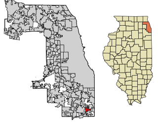
Pill Hill is a neighborhood in the Calumet Heights community area on the South Side of Chicago, Illinois, United States.
Pill Hill is a neighborhood in the Calumet Heights community area on the South Side of Chicago, Illinois, United States.

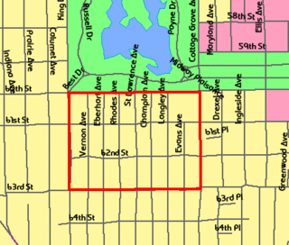
According to The Electronic Encyclopedia of Chicago , the neighborhood is the more affluent portion of the Stony Island Heights neighborhood that occupies the eastern two-thirds of Calumet Heights. [1] Several sources more loosely define Pill Hill as the entire Calumet Heights region and use the names interchangeably to refer to the whole area. [2] [3] Other sources including one co-published by MSNBC, clearly depict it as a rectangular neighborhood running for eight blocks bounded by East 91st or East 92nd Street and East 94th or East 95th Street to the north and south, respectively, and South Paxton Avenue and South Cregier Avenue to the east and west, respectively. [4] [5] The neighborhood is known for homes with built-in one-car garages and private yards. The region has little commercial development. [5]
The neighborhood was first settled by farmers who quickly became disappointed in the region's swampy nature. [4] After the area was developed by nearby factory workers in the 1870s, it was incorporated into the city of Chicago in 1889 along with the Hyde Park Township. [1] [4] In the 1940s, the factory workers were replaced by white collar residents. [4] By the 1970s, the neighborhood had earned a reputation for affluence and quality residences. The neighborhood soon became a favorite residence of African American doctors from the nearby South Chicago Community Hospital. [4] In a community area of above average wealth compared to the Chicago statistical averages, [2] Pill Hill has above-average affluence compared to the rest of the community area according to the Encyclopedia. [1] The moniker is attributed to the preponderance of doctors employed at the nearby South Chicago Community Hospital who reside in the grand homes situated atop the Stony Island ridge. [1] However, the neighborhood no longer hosts such a high concentration of doctors and is a varied middle-class neighborhood. [4] The racial transformation has been documented in the 1998 book entitled The South Side: The Racial Transformation of an American Neighborhood. [1] [6] [7] A play by Yale School of Drama graduate Sam Kelley entitled Pill Hill was set in this neighborhood. It debuted at the Yale Repertory Theatre has been produced in many venues in recent decades. [8] [9] Pill Hill is credited by one Chicago Sun-Times author as one of the few communities to host civil rights activists such as Martin Luther King, Jr. and Jesse Jackson during the 1960s. [10]
| By topic | |
|---|---|
Ford Heights is a village in Cook County, Illinois, United States. The population was 2,763 at the 2010 census. It is located approximately 25 miles (40 km) south of downtown Chicago. The village suffers from high levels of crime and poverty and was once known as the poorest suburb in America.
Highland is a town in Lake County, Indiana, United States. The population was 23,727 at the 2010 census. The town was incorporated on April 4, 1910. It is a part of the Chicago metropolitan area and North Township, and is surrounded by Hammond to the north, Munster to the west, Schererville to the south and Griffith to the east.
South Shore is one of 77 defined community areas of Chicago, Illinois, United States. A predominantly African-American neighborhood on the city's South Side, the area is named for its location along the city's southern lakefront. Although South Shore has seen a greater than 40% decrease in residents since Chicago's population peaked in the 1950s, the area remains one of the most densely populated neighborhoods on the South Side. The community benefits from its location along the waterfront, its accessibility to Lake Shore Drive, and its proximity to major institutions and attractions such as the University of Chicago, the Museum of Science and Industry, and Jackson Park.

South Chicago, formerly known as Ainsworth, is one of the 77 well-defined community areas of Chicago, Illinois.

Burnside is one of the 77 community areas in Chicago. The 47th numbered area, it is located on the city's far south side. This area is also called "The Triangle" by locals, as it is bordered by railroad tracks on every side; the Canadian National Railway on the west, the Union Pacific Railroad on the south and the Norfolk Southern Railway on the east. With a population of 2,254 in 2016, it is the least populous of the community areas, as well as the second smallest by area after Oakland.

Calumet Heights, located on the South Side of the city, is one of the 77 well defined community areas of Chicago, Illinois. Calumet Heights is bounded by 87th Street on the north, South Chicago Avenue on the east, and railroad lines on the west and south.

South Deering, located on Chicago's far South Side, is the largest of the 77 official community areas of that city. It is part of the 10th Ward, once under the control of former Richard J. Daley ally Alderman Edward Vrdolyak. Primarily an industrial neighborhood, a small group of homes exists in the northeast corner and Lake Calumet takes up a large portion of the area. 80% of the community is zoned as industrial, natural wetlands, or parks. The remaining 20% is zoned for residential and small-scale commercial uses. The neighborhood is named for Charles Deering, an executive in the Deering Harvester Company that would later form a major part of International Harvester. International Harvester owned Wisconsin Steel, which was originally established in 1875 and was located along Torrence Avenue south of 106th Street to 109th Street.

East Side is one of the 77 official community areas of Chicago, Illinois. It is on the far south side of the city, between the Calumet River and the Illinois-Indiana state line, 13 miles (21 km) south of downtown Chicago. The neighborhood has a park on Lake Michigan, Calumet Park, and a forest, Eggers Grove Forest Preserve. The forest preserve has hiking/walking trails, picnic grounds and birdwatching. It is served by U.S. Highway 12, U.S. Highway 20, and U.S. Highway 41.
Riverdale is one of the 77 official community areas of Chicago, Illinois and is located on the city's far south side.

Washington Heights is the 73rd of Chicago's 77 community areas. Located 12 miles (19 km) from the Loop, it is on the city's far south side. Washington Heights is considered part of the Blue Island Ridge, along with the nearby community areas of Beverly, Morgan Park and Mount Greenwood, and the village of Blue Island. It contains a neighborhood also known as Washington Heights, as well as the neighborhoods of Brainerd and Fernwood. As of 2017, Washington Heights had 27,453 inhabitants.

Illinois's 2nd congressional district is a congressional district in the U.S. state of Illinois. Based in the south suburbs of Chicago, the district includes southern Cook county, eastern Will county, and Kankakee county, as well as the city of Chicago's far southeast side.

The Chicago Southland is a region comprising the south and southwest suburbs of the City of Chicago in the U.S. state of Illinois. Home to roughly 2.5 million residents, this region has been known as the Southland by the local populace and regional media for over 20 years.
The Washington Park Subdivision is the name of the historic 3-city block by 8-city block subdivision in the northwest corner of the Woodlawn community area, on the South Side of Chicago in Illinois that stands in the place of the original Washington Park Race Track. The area evolved as a redevelopment of the land previously occupied by the racetrack. It was originally an exclusively white neighborhood that included residential housing, amusement parks, and beer gardens.
Stony Island Avenue is a major street on South Side of the city of Chicago, designated 1600 East in Chicago's street numbering system. It runs from 56th Street south to the Calumet River. Stony Island Avenue continues sporadically south of the Calumet in the southern suburbs, running alongside the Bishop Ford Freeway, sometimes as a frontage road. It terminates at County Line Road on the border of Will and Kankakee Counties.
The Washington Park Court District is a Grand Boulevard community area neighborhood on the South Side of Chicago, Illinois. It was designated a Chicago Landmark on October 2, 1991. Despite its name, it is not located within either the Washington Park community area or the Washington Park park, but is one block north of both. The district was named for the Park.
The Calumet/Giles Prairie District is a historic district in the South Side, Chicago community area of Chicago, Illinois, United States. The district was built between 1870 and 1910 by various architects. It was designated a Chicago Landmark on July 13, 1988.
95th Street is a major east–west highway on Chicago's South Side and in the southwest suburbs, designated as 9500 South in Chicago's address system. 95th Street is 11 miles (18 km) south of Madison Street.
Pill Hill is a three-act play by American dramatist Sam Kelley. Set in a neighborhood on the South Side of Chicago known informally as Pill Hill, the play examines the failures, successes, and relationships of six African American steel mill workers as they transition from blue-collar jobs to white-collar professions between 1973 and 1983. The play is regarded as an allegory of economic progress related to the American Dream.
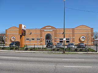
Bronzeville Children's Museum is a museum in the Calumet Heights community area of the South Side of Chicago. It is the first and only African American children's museum in the United States. Founded in 1998, the museum moved to its current location at 9301 South Stony Island Avenue in the Pill Hill neighborhood in 2008.