West Garfield Park, Chicago

Last updated

West Garfield Park
Community Area 26 - West Garfield Park
Pulaski Green Line.jpg
US-IL-Chicago-CA26.svg
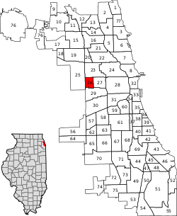
Location within the city of Chicago
Coordinates: 41°52.8′N87°43.8′W / 41.8800°N 87.7300°W / 41.8800; -87.7300
CountryUnited States
StateIllinois
County Cook
CityChicago
Neighborhoods
list
  • West Garfield Park
Area
  Total1.28 sq mi (3.32 km2)
Population
 (2020)
  Total17,433 [1]
Demographics 2020 [1]
   White 2.8%
  Black92.4%
  Hispanic3.5%
  Asian0.0%
  Other1.3%
Educational Attainment 2020 [1]
  High School Diploma or Higher74.7%
  Bachelor's Degree or Higher7.0%
Time zone UTC-6 (CST)
  Summer (DST) UTC-5 (CDT)
ZIP Codes
parts of 60624
Median household income (2020) [1] $29,443
Source: U.S. Census, Record Information Services

West Garfield Park on the West Side of Chicago, Illinois, is one of 77 officially designated Chicago community areas. [2] It is directly west of Garfield Park.

Contents

Neighborhood boundaries

The boundaries of West Garfield Park are NORTH: W. Kinzie St. EAST: Hamlin Blvd/ S. Independence Blvd. SOUTH: W. Taylor St. from S. Independence Blvd to S. Kildare Ave., S. Kildare Ave. from W. Taylor St. to W. 5th Ave, W. 5th Ave. from S. Kildare Ave. to S. Kolmar Ave. WEST: S. Kolmar Ave from W. 5th Ave. to W. Jackson Blvd., W. Jackson Blvd. from S. Kolmar Ave. to S. Kenton Ave., S. Kenton Ave. from W. Jackson Blvd. to W. Madison St., W. Madison St. from S. Kenton Ave. to N. Kenton Ave., N. Kenton Ave. to W. Kinzie St. [3]

K-Town

K-Town is a nickname for an area in Humboldt Park, North Lawndale, and West Garfield Park. Although these long streets extend beyond the bounds of North Lawndale, and West Garfield Park, published sources identify the name K-Town as referring specifically to an area of North Lawndale, and West Garfield Park, i.e. the area through which these streets pass. between Pulaski Road and Cicero Avenue in which the names of many north-south avenues begin with the letter K (Keystone, Karlov, Kedvale, Keeler, Kenneth, Kilbourn, Kildare, Kolin, Kolmar, Komensky, Kostner, Kilpatrick, Kenton, Knox, and Keating). The pattern is a historical relic of a 1913 street-naming proposal, by which streets were to be systematically named according to their distance from the Illinois-Indiana border; K, the eleventh letter, was to be assigned to streets within the eleventh mile, counting west from the state line. The eleventh mile is the easternmost area in which the plan was widely implemented, as many neighborhoods to the east were already developed and had street names in place. The portion of K-Town bounded by W. Kinzie St, W. Cermak Rd, S. Kostner Ave, and S. Pulaski Rd was listed as a historic district on the National Register of Historic Places on September 9, 2010.

Government and infrastructure

The United States Postal Service operates the Mary Alice Henry Post Office at 4222 West Madison Street. [4]

Bethel New Life, Inc. is a main community service provider to the area. [5]

The Chicago Tool Library is headquartered in the area.

Transportation

Two of the Chicago Transit Authority's train lines, the Blue Line and the Green Line, serve this neighborhood. The Green Line has an elevated station at Pulaski, and the Blue Line has a station in the median of the Eisenhower Expressway, also at Pulaski.

Historical population
CensusPop.Note
1930 50,014
1940 48,447−3.1%
1950 48,4430.0%
1960 45,661−5.7%
1970 48,4596.1%
1980 33,865−30.1%
1990 24,095−28.8%
2000 23,019−4.5%
2010 18,001−21.8%
2020 17,433−3.2%
[1] [6]

Crime

The neighborhood's 21 murders in 2014 occurred at a rate of 116 per 100,000, giving this neighborhood the highest murder rate in Chicago. In a city that sees 2,000 shootings per annum, they occur in West Garfield Park at a rate of 411 per 100,000.

In 2016, the violence increased further, with a total of 31 murders, resulting in a murder rate of 172 per 100,000. Additionally, at least 172 people were shot during 2016, resulting in a shooting rate of 950 per 100,000 people. [7]

Related Research Articles

<span class="mw-page-title-main">Humboldt Park, Chicago</span> Community area in Chicago

Humboldt Park, one of 77 designated community areas, is on the West Side of Chicago, Illinois. The Humboldt Park neighborhood is known for its dynamic social and ethnic demographic change over the years. The Puerto Rican community has identified strongly with the area since the 1970s. Humboldt Park is also the name of a 207-acre (0.8 km2) park adjacent to the community area.

<span class="mw-page-title-main">Roads and expressways in Chicago</span> Highway system

Roads and expressways in Chicago summarizes the main thoroughfares and the numbering system used in Chicago and its surrounding suburbs.

<span class="mw-page-title-main">Hermosa, Chicago</span> Community area in Chicago

Hermosa is one of 77 designated Chicago community areas and is located on the northwest side of Chicago, Illinois. The Hermosa community area contains the Kelvyn Park and Hermosa neighborhoods. The area includes the birthplace of Walt Disney and is the former headquarters of the Schwinn Bicycle Company. While being one of the smaller community areas, Hermosa is one of the city's most densely populated neighborhoods.

<span class="mw-page-title-main">Irving Park, Chicago</span> Community area in Chicago

Irving Park is one of 77 officially designated Chicago community areas, and is located on the Northwest Side. It is bounded by the Chicago River on the east, the Milwaukee Road railroad tracks on the west, Addison Street on the south and Montrose Avenue on the north, west of Pulaski Road stretching to encompass the region between Belmont Avenue on the south and, roughly, Leland Avenue on the north. It is named after the American author Washington Irving.

<span class="mw-page-title-main">West Town, Chicago</span> Community area in Chicago

West Town, northwest of the Loop on Chicago's West Side, is one of the city's officially designated community areas. Much of this area was historically part of Polish Downtown, along Western Avenue, which was then the city's western boundary. West Town was a collection of several distinct neighborhoods and the most populous community area until it was surpassed by Near West Side in the 1960s. The boundaries of the community area are the Chicago River to the east, the Union Pacific railroad tracks to the south, the former railroad tracks on Bloomingdale Avenue to the North, and an irregular western border to the west that includes the city park called Humboldt Park. Humboldt Park is also the name of the community area to West Town's west, Logan Square is to the north, Near North Side to the east, and Near West Side to the south. The collection of neighborhoods in West Town along with the neighborhoods of Bucktown and the eastern portion of Logan Square have been referred to by some media as the "Near Northwest Side".

<span class="mw-page-title-main">East Garfield Park, Chicago</span> Community area in Chicago

East Garfield Park is on the West Side of Chicago, Illinois, west of the Loop.

<span class="mw-page-title-main">North Lawndale, Chicago</span> Community area in Chicago

North Lawndale is one of the 77 community areas of the city of Chicago, Illinois, located on its West Side. The area contains the K-Town Historic District, the Foundation for Homan Square, the Homan Square interrogation facility, and the greatest concentration of greystones in the city. In 1968, Rev. Dr. Martin Luther King Jr. stayed in an apartment in North Lawndale to highlight the dire conditions in the area and used the experience to pave the way to the Fair Housing Act.

The Almighty Vice Lord Nation is the second-largest and one of the oldest street and prison gangs in Chicago, Illinois. Its total membership is estimated to be between 30,000 and 35,000. It is also one of the founding members of the People Nation multi-gang alliance.

<span class="mw-page-title-main">California's 43rd congressional district</span> U.S. House district for California

California's 43rd congressional district is a congressional district in the U.S. state of California that is currently represented by Democrat Maxine Waters. The district is centered in the southern part of Los Angeles County, and includes portions of the cities of Los Angeles and Torrance. It includes the entirety of the cities of Hawthorne, Lawndale, Gardena, Inglewood, and Lomita. From 2003 until 2013, the 43rd district was based in San Bernardino County. The Hispanic-majority district encompassed the southwestern part of the county, and included San Bernardino and Rialto.

<span class="mw-page-title-main">Kostner station (CTA Pink Line)</span> Chicago rapid transit station

Kostner, formerly known as Kildare, is an 'L' station on the CTA's Pink Line. It is located in the K-Town neighborhood of the North Lawndale community area, often just referred to as Lawndale. Kostner station was originally opened as Kildare. During reconstruction in 2003, its primary entrance was moved one block west to Kostner Avenue and the Kildare entrance became an auxiliary entrance.

<span class="mw-page-title-main">Illinois's 4th congressional district</span> U.S. House district for Illinois

The 4th congressional district of Illinois includes part of Cook County, and has been represented by Democrat Jesús "Chuy" García since January 2019.

<span class="mw-page-title-main">Pulaski Road (Chicago)</span> Major street in Chicago, Illinois, U.S.

Pulaski Road is a major north-south street in the city of Chicago, at 4000 W., or exactly five miles west of State Street. It is named after Polish hero of the American Revolutionary War Casimir Pulaski.

<span class="mw-page-title-main">Cermak Road</span>

Cermak Road, also known as 22nd Street, is a 19-mile, major east–west street on Chicago's near south and west sides and the city's western suburbs. In Chicago's street numbering system, Cermak is 2200 south, or twenty-two blocks south of the baseline of Madison Street. Normally, one mile comprises eight Chicago blocks, but the arterial streets Roosevelt Road, formerly named Twelfth Street and at 1200 South, and Cermak Road were platted before the eight-blocks-per-mile plan was implemented. Roosevelt Road is one mile south of Madison Avenue and there are twelve blocks within that mile. Cermak Road is two miles south of Madison Avenue and there are ten blocks within the mile between Roosevelt and Cermak Roads.

<span class="mw-page-title-main">Kostner station (CTA Congress Line)</span>

Kostner is an abandoned rapid transit station in the West Garfield Park neighborhood of Chicago, Illinois. The station served the Chicago Transit Authority's Congress Line, which is now part of the Blue Line. Kostner opened on August 5, 1962; it was one of two stations on the Congress Line which was not opened with the line on June 22, 1958. The station closed on September 2, 1973, due to low ridership.

The Spanish Cobras is a primarily, but not exclusively, Latino street gang in multiple states throughout the Midwest, USA with a strong presence on the north and west side of Chicago, Illinois.

<span class="mw-page-title-main">Park West (Miami)</span> Neighborhood of Miami in Miami-Dade County, Florida, United States

Park West is a neighborhood of Greater Downtown, Miami, Florida. It is roughly bound by Biscayne Boulevard to the east, West (NW) First Avenue to the west, North (NE/NW) 7th Street to the south and Interstate 395 to the north. As of 2010, about 4,655 residents live in Park West. The neighborhood is named 'Park West' due to its location just west of Museum Park.

<span class="mw-page-title-main">Cermak branch</span>

The Cermak branch, formerly known as the Douglas branch, is a 6.6 mi (10.6 km) long section of the Pink Line of the Chicago "L" system in Chicago, Illinois. It was built by the Metropolitan West Side Elevated west of the Loop. As of February 2013, it serves an average of 17,474 passengers every weekday. The branch serves the Near West Side, Pilsen, Lower West Side, South Lawndale, and North Lawndale neighborhoods of Chicago, and the west suburb Cicero, Illinois. The branch operates from 4:05 a.m. to 1:25 a.m., weekdays, and Saturdays from 5:05 a.m. to 1:25 a.m., and Sundays from 5:00 a.m. to 1:25 a.m., including holidays.

<span class="mw-page-title-main">West Side, Chicago</span> District in Illinois, United States

The West Side is one of the three major sections of the city of Chicago, Illinois, U.S. The other two sections within Chicago that associate with the West Side are the North Side and the South Side. The West Side consists of communities that are of historical, cultural, and ideological importance to the history and development of Chicago. On the flag of Chicago, the West Side is represented by the central white stripe.

<span class="mw-page-title-main">K-Town Historic District</span> Historic district in Illinois, United States

The K-Town Historic District is a historic district listed on the National Register of Historic Places located in the North Lawndale community area in Chicago, Illinois. A mainly residential area, its borders are West Cullerton Street to the north, South Pulaski Road to the east, West Cermak Road to the south, and South Kostner Avenue to the west.

References

  1. 1 2 3 4 5 "Community Data Snapshot - West Garfield Park" (PDF). cmap.illinois.gov. MetroPulse. Retrieved February 28, 2023.
  2. "East Garfield Park". Encyclopedia.chicagohistory.org. Retrieved September 23, 2017.
  3. "Find an apartment in a great neighborhood – YoChicago". Yochicago.com. Retrieved September 23, 2017.
  4. "Post Office Location - MARY ALICE HENRY". United States Postal Service . Retrieved April 17, 2009.
  5. "Bethel New Life -". Bethelnewlife.org. Retrieved September 9, 2015.
  6. Paral, Rob. "Chicago Community Areas Historical Data". Robparal.com. Retrieved September 2, 2012.
  7. "Crime in Chicago -- Chicago Tribune". Crime.chicagotribune.com. Retrieved September 23, 2017.