Gage Park, Chicago

Last updated

Gage Park
Community Area 63 - Gage Park
Gage Park (7979597973).jpg
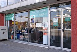
Gage Park branch of Chicago Public Library on 55th Street.
US-IL-Chicago-CA63.svg
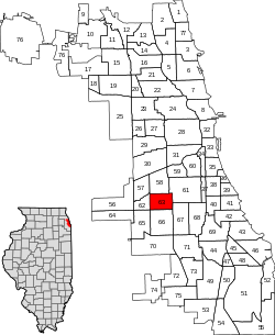
Location within the city of Chicago
Coordinates: 41°47.4′N87°41.4′W / 41.7900°N 87.6900°W / 41.7900; -87.6900
Country Flag of the United States (23px).png  United States
State Flag of Illinois.svg  Illinois
County Cook
City Chicago
Neighborhoods
list
  • Gage Park
  • Marquette Manor
  • Glendale
  • Garfield Manor
Area
  Total2.24 sq mi (5.80 km2)
Population
 (2020) [1]
  Total39,540
  Density18,000/sq mi (6,800/km2)
Demographics (2020)
[1]
   White 3.6%
  Black4.7%
  Hispanic91.0%
  Asian0.7%
  Other0.1%
Educational Attainment (2020) [1]
  High School Diploma or Higher67.4%
  Bachelor's Degree or Higher8.6%
Time zone UTC-6 (CST)
  Summer (DST) UTC-5 (CDT)
ZIP Codes
parts of 60609, 60629, 60632 and 60636
Median income (2020) [1] $42,271
Source: U.S. Census, Record Information Services

Gage Park is one of Chicago's 77 well-defined community areas, located on the city's southwest side; it is also the name of a park within the neighborhood. Gage Park's population is largely working-class, and its housing stock is mostly bungalows. For generations, the neighborhood was Eastern European and Irish Catholic. The neighborhood remains overwhelmingly Catholic with the addition of many Hispanic residents. Gage Park is bounded by 49th Street to the north, 59th Street to the south, Central Park Ave to the west, and Leavitt Street to the east.

Contents

History

The development of Gage Park began in 1873 when South Park Commissioner George W. Gage began working on a planned park at the intersection of Western Ave. and Garfield Boulevard. Upon Gage's death in 1875, the park was renamed Gage Park in his honor.

The area developed after Gage's passing, slowly adding more and more land and offering up more services to the local community. By 1919, Gage Park had added more land and the park now included ball fields, tennis courts, separate men's and women's gymnasiums, gardens, and a wading pool. A large field house and auditorium was later added in 1928, with a large mural by Tom Lea added in 1931.

On February 4, 2016, the bodies of six people were discovered in a home on the 5700 block of South California Avenue.

Education

Gage Park High School Gage Park High School Chicago.jpg
Gage Park High School

Chicago Public Schools operates district public schools. [2]

The United Neighborhood Organization operates the charter schools Rufino Tamayo School and Jovita Idar School. [5]

Politics

The Gage Park community area has supported the Democratic Party in the past two presidential elections. In the 2016 presidential election, the Gage Park cast 6,966 votes for Hillary Clinton and cast 494 votes for Donald Trump (90.44% to 6.41%). [6] In the 2012 presidential election, Gage Park cast 5,725 votes for Barack Obama and cast 554 votes for Mitt Romney (90.27% to 8.74%). [7]

Historical population
CensusPop.Note
1930 31,535
1940 30,343−3.8%
1950 30,149−0.6%
1960 28,244−6.3%
1970 26,698−5.5%
1980 24,445−8.4%
1990 26,95710.3%
2000 39,19345.4%
2010 39,8941.8%
2020 39,540−0.9%
[1] [8]

Religion

The Roman Catholic Archdiocese of Chicago operates Catholic churches. On July 1, 2020, St. Gall Parish will incorporate St. Simon the Apostle Parish into its structure, and St. Gall will be the main church of the merged entity. On the same day St. Rita of Cascia Parish will incorporate St. Clare of Montefalco, and the former will be the main church of the combined entity. [9]

Notable people

Related Research Articles

<span class="mw-page-title-main">Jefferson Park, Chicago</span> Community area in Chicago

Jefferson Park is one of the 77 community areas of Chicago, located on the northwest side of the city. The neighborhood of Jefferson Park occupies a larger swath of territory.

<span class="mw-page-title-main">Norwood Park, Chicago</span> Community area in Chicago

Norwood Park is one of the 77 Chicago community areas. It encompasses the smaller neighborhoods of Big Oaks, Norwood Park East, Norwood Park West, Old Norwood Park, Oriole Park, and Union Ridge.

<span class="mw-page-title-main">North Park, Chicago</span> Community area in Chicago

North Park is one of 77 well-defined community areas of the City of Chicago. It is bordered by the North Shore Channel on the east, the Chicago River's North Branch and Foster Avenue on the south, Cicero Avenue on the west and Devon Avenue on the north.

<span class="mw-page-title-main">Archer Heights, Chicago</span> Community area in Chicago

Archer Heights is a community area in Chicago, Illinois, one of the 77 official community areas of Chicago.

<span class="mw-page-title-main">Belmont Cragin, Chicago</span> Community area in Chicago

Belmont Cragin is one of 77 officially designated Chicago community areas located on the Northwest Side of the City of Chicago, Illinois. It is designated Community Area 19, and is located 8 miles (13 km) NW of the Loop.

<span class="mw-page-title-main">Forest Glen, Chicago</span> Community area in Chicago

Forest Glen is one of the 77 official city community areas of Chicago, Illinois, located on the city's Northwest Side. It comprises the neighborhoods of Forest Glen, Edgebrook and Sauganash, with sub-neighborhoods of Sauganash Park, Wildwood, North Edgebrook and Old Edgebrook.

<span class="mw-page-title-main">West Lawn, Chicago</span> Community area in Chicago

West Lawn, one of Chicago's 77 official community areas, is located on the southwest side of the city. It is considered to be a "melting pot" of sorts, due to its constant change of races moving in and out of the area, as well as the diversity that exists there. It has a small town atmosphere in the big city. West Lawn is home to many Polish-Americans, Irish-Americans, Mexican-Americans, and other people of Latin American and Eastern European origin.

<span class="mw-page-title-main">Armour Square, Chicago</span> Community area in Illinois, United States

Armour Square is a Chicago neighborhood on the city's South Side, as well as a larger, officially defined community area, which also includes Chinatown and the CHA Wentworth Gardens housing project. Armour Square is bordered by Bridgeport to the west, Pilsen to the northwest, Douglas and Grand Boulevard to the east and southeast, and with the Near South Side bordering the area to the north, and Fuller Park bordering its southernmost boundary, along Pershing Road.

<span class="mw-page-title-main">Portage Park, Chicago</span> Community area in Chicago

Portage Park is located on the northwest side of the City of Chicago, Illinois and is one of 77 officially designated Chicago community areas. Portage Park is bordered by the community areas of Jefferson Park and Forest Glen to the north, Dunning and the suburb of Harwood Heights to the west, Irving Park to the east and Belmont-Cragin to the south.

<span class="mw-page-title-main">Ashburn, Chicago</span> Community area in Chicago

Ashburn, one of Chicago's 77 community areas, is located on the south side of the city. Greater Ashburn covers nearly five square miles. The approximate boundaries of Ashburn are 72nd Street (north), Western Avenue (east), 87th Street (south) and Cicero Avenue (west).

<span class="mw-page-title-main">West Pullman, Chicago</span> Community area in Chicago

West Pullman is a neighborhood located on the far south side of the city of Chicago, Illinois. It is one of the 77 official community areas of Chicago. The Neighborhood of West Pullman was largely inhabited by workers of the Pullman Train Company who were looking to escape the grip of the company town Pullman. The commercial corridor of Kensington/115th Street was one of many Italian communities within Chicago.

<span class="mw-page-title-main">West Ridge, Chicago</span> Community area in Chicago

West Ridge is one of 77 Chicago community areas. It is a middle-class neighborhood located on the far North Side of the City of Chicago. It is located in the 50th ward and the 40th ward.

<span class="mw-page-title-main">South Lawndale, Chicago</span> Community area in Chicago

South Lawndale is a community area on the West Side of Chicago, Illinois. Over 80% of the residents are of Mexican descent and the community is home to the largest foreign-born Mexican population in Chicago.

<span class="mw-page-title-main">Kenwood, Chicago</span> Community area in Chicago

Kenwood, one of Chicago's 77 community areas, is on the shore of Lake Michigan on the South Side of the city. Its boundaries are 43rd Street, 51st Street, Cottage Grove Avenue, and the lake. Kenwood was originally part of Hyde Park Township, which was annexed to the city of Chicago in 1889. Kenwood was once one of Chicago's most affluent neighborhoods, and it still has some of the largest single-family homes in the city. It contains two Chicago Landmark districts, Kenwood and North Kenwood. A large part of the southern half of the community area is in the Hyde Park-Kenwood Historic District. In recent years, Kenwood has received national attention as the home of former U.S. President Barack Obama.

<span class="mw-page-title-main">Avalon Park, Chicago</span> Community area in Chicago

Avalon Park, located on the south side of the U.S. city of Chicago, Illinois, is one of the city's 77 semi-official community areas and is named after its main park. Its boundaries are 76th St. to the north, South Chicago Ave. to the east and 87th St. to the south. The community area includes the neighborhoods of Avalon Park, Marynook and Stony Island Park.

<span class="mw-page-title-main">East Side, Chicago</span> Community area in Chicago

East Side is one of the 77 official community areas of Chicago, Illinois. It is on the far south side of the city, between the Calumet River and the Illinois-Indiana state line, 13 miles (21 km) south of downtown Chicago. The neighborhood has a park on Lake Michigan, Calumet Park, and a forest, Eggers Grove Forest Preserve. The forest preserve has hiking/walking trails, picnic grounds and birdwatching. It is served by U.S. Highway 12, U.S. Highway 20, and U.S. Highway 41.

<span class="mw-page-title-main">West Elsdon, Chicago</span> Community area in Chicago

West Elsdon, one of the 77 official community areas, is located on the southwest side of the City of Chicago, Illinois. It is noted as a twin neighborhood of West Lawn. It has a population which includes a mix of dwindling Polish-American residents and increasing Mexican-American residents who currently constitute a clear majority. It has its own association, "West Elsdon Civic Association," which privately organizes the neighborhood. St. Turibius grade school, a Roman Catholic elementary school, located at 57th and Karlov, closed in 2013 and is currently inactive though the building remains and is adjacent to St. Turibius Roman Catholic church. The former Lourdes Roman Catholic girls' high school located from 55th to 56th street from Komensky to Karlov Avenue is now a Chicago Public Schools magnet high school, John Hancock High School.

<span class="mw-page-title-main">Clearing, Chicago</span> Community area in Chicago

Clearing, one of the 77 semi-official community areas, is located on the southwest side of the city of Chicago, Illinois. The southern portion of Chicago Midway International Airport is located within this community area.

<span class="mw-page-title-main">Chicago Lawn, Chicago</span> Community area in Chicago

Chicago Lawn is one of the 77 community areas of Chicago, Illinois. It is located on the southwest side of the city. Its community neighbors include Gage Park, West Englewood, Ashburn, and West Lawn. It is bounded by Bell Avenue on the east, Central Park Avenue on the west, 59th Street on the north, and 75th Street on the south, and is 13 km (8.1 mi) southwest of the Loop. Local citizens refer to the area as "Marquette Park," after the park in its center.

<span class="mw-page-title-main">Auburn Gresham, Chicago</span> Community area in Chicago

Auburn Gresham, most commonly referred to simply as Gresham, is one of the 77 official community areas of the city of Chicago, Illinois. It is located on the far south side of the city and was the original location of the South Side Irish Parade before it was relocated to the adjoining Beverly neighborhood immediately southwest.

References

  1. 1 2 3 4 5 "Community Data Snapshot - Gage Park" (PDF). cmap.illinois.gov. MetroPulse. Retrieved February 28, 2023.
  2. "Gage Park." City of Chicago. Retrieved on January 21, 2017. Compare this map to the CPS maps.
  3. "West Central South" (high school zones). Chicago Public Schools. July 19, 2013. Retrieved on January 11, 2017.
  4. "Gage Park High School (9-12) - City of Chicago SD 299". Illinois Report Card. Illinois State Board of Education. Retrieved June 17, 2015.
  5. "UNO Charter Schools Archived April 30, 2012, at the Wayback Machine ." United Neighborhood Organization. Retrieved on June 16, 2012.
  6. Ali, Tanveer (November 9, 2016). "How Every Chicago Neighborhood Voted In The 2016 Presidential Election". DNAInfo . Archived from the original on September 24, 2019. Retrieved October 4, 2019.
  7. Ali, Tanveer (November 9, 2012). "How Every Chicago Neighborhood Voted In The 2012 Presidential Election". DNAInfo . Archived from the original on February 3, 2019. Retrieved October 4, 2019.
  8. Paral, Rob. "Chicago Community Areas Historical Data". Archived from the original on March 18, 2013. Retrieved September 3, 2012.
  9. Anderson, Javonte (February 7, 2020). "23 Chicago-area Roman Catholic parishes to close, merge in latest round of restructuring". Chicago Tribune . Retrieved May 8, 2020.
  10. Breen, Justin (December 16, 2014). "After Injury, Former NFL Player Becomes Full-Time 'Computer Geek'". DNAInfo Chicago. Archived from the original on September 25, 2017. Retrieved September 24, 2017.
  11. United States Congress. "William T. Redmond (ID: R000567)". Biographical Directory of the United States Congress . Retrieved December 10, 2018.
  12. Oxley, Jim. "Wisconsin Football Senior Spotlight: James Adeyanju". Badger of Honor. Retrieved May 2, 2019.